
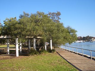
Albury is a major regional city that is located in the Murray region of New South Wales, Australia. It is part of the twin city of Albury-Wodonga and is located on the Hume Highway and the northern side of the Murray River. Albury is the seat of local government for the council area which also bears the city's name – the City of Albury. It is on the Victoria–New South Wales border.

Tamworth is a city and administrative centre of the north-eastern region of New South Wales, Australia. Situated on the Peel River within the local government area of the Tamworth Regional Council, it is the largest and most populated city in the region, with a population of 43,874 in 2021, making it the second largest inland city in New South Wales. Tamworth is 318 km (198 mi) from the Queensland border and is located almost midway between Brisbane and Sydney.

Wollongong is a city located in the Illawarra region of New South Wales, Australia. The name is believed to originate from the Dharawal language, meaning either 'five islands/clouds', 'ground near water' or 'sound of the sea'. Wollongong lies on the narrow coastal strip between the Illawarra Escarpment and the Pacific Ocean, 85 kilometres south of central Sydney. Wollongong had an estimated urban population of 302,739 at June 2018, making it the third-largest city in New South Wales after Sydney and Newcastle and the tenth-largest city in Australia by population. The city's current Lord Mayor is Gordon Bradbery AM who was elected in 2021.
Berry is a small Australian village in the Shoalhaven region of the New South Wales South Coast, located 143 km (89 mi) south of the state capital, Sydney. It has many historical buildings which are listed on the New South Wales Heritage Register. Berry attracts many tourists who come to enjoy the diversity of landscapes, including coastal beaches, rich dairy farming, and forested mountains. The village hosts a local Produce Market which is held twice each month on the second Saturday and fourth Sunday. Together with Kiama 23 km (14 mi) to the north, Berry acts as a gateway through to other towns and villages along the South Coast of NSW via the Princes Highway and the South Coast railway line. Major highway building projects in and around Berry have now bypassed the village, creating uninterrupted motorway conditions for coastal travel south to Nowra and the South Coast and north to Wollongong and Sydney. This has resulted in the removal of all but local and visitor traffic within the village. Planning is underway to create a pedestrian-friendly precinct in and around Queens Street.

Uralla is a town on the Northern Tablelands, New South Wales, Australia. It is located at the intersection of the New England Highway and Thunderbolts Way, 465 kilometres (289 mi) north of Sydney and about 23 kilometres (14 mi) south-west of the city of Armidale. At the 2016 census, the township of Uralla had a population of 2,388 people. According to the 2021 census, the population of Uralla had increased to 2,728.

Bingara is a small town on the Gwydir River in Murchison County in the New England region of New South Wales, Australia. Bingara is currently the administrative centre for the Gwydir Shire that was created in 2003. The Gwydir River being a main highlight of the town is a main catchment of the Murray-Darling System.

Molong is a small town in the Central West region of New South Wales, Australia, in Cabonne Shire.

Nyngan is a town in the centre of New South Wales, Australia, in the Bogan Shire local government area within the Orana Region of central New South Wales. At the 2016 census, Nyngan had a population of 1,988 people. Nyngan is situated on the Bogan River between Narromine and Bourke, on the junction of the Mitchell Highway and Barrier Highway, 656 km (408 mi) south of Charleville and 576 km (358 mi) north-west of Sydney by road. The Barrier Highway starts at Nyngan, and runs west to Cobar and on through Wilcannia and Broken Hill into South Australia.

Summer Hill is a suburb of Sydney, in the state of New South Wales, Australia. Summer Hill is located 7 kilometres west of the Sydney central business district, in the local government area of the Inner West Council.

Naracoorte is a town in the Limestone Coast region of South Australia, approximately 336 kilometres south-east of Adelaide and 100 kilometres north of Mount Gambier on the Riddoch Highway (A66).
Lilyfield is a suburb in the Inner West of Sydney, in the state of New South Wales, Australia. Lilyfield is located 6 kilometres west of the Sydney central business district, in the local government area of the Inner West Council.

Lewisham is a suburb in the Inner West of Sydney, in the state of New South Wales, Australia. Lewisham is located 7 kilometres south-west of the Sydney central business district, in the local government area of Inner West Council.

Ultimo is an inner-city suburb of Sydney, New South Wales, Australia. It is adjacent to the Sydney central business district in the local government area of the City of Sydney west of the Darling Harbour area, and is bordered by Pyrmont to the north, the Sydney CBD and Chinatown/Haymarket to the east, Broadway and Chippendale to the south, and Glebe and Wentworth Park to the west.
Lyndhurst is a small village in New South Wales, Australia in Blayney Shire. It is 4 kilometres west of Mandurama or about 269 km west of Sydney and 63 km south-west of Bathurst just off the Mid-Western Highway New South Wales. Once serving as the major centre for basic goods and needs to the nearby Junction Reefs goldfields. At the 2016 census, Lyndhurst had a population of 267 people.

Bowning is a small town in the South West Slopes, 14 kilometres (8.7 mi) west of Yass on the Hume Highway in Yass Valley Shire. Bowning is an aboriginal word meaning 'big hill'. At the 2016 census, Bowning and the surrounding area had a population of 573.

Cabonne Council is a local government area in the Central West region of New South Wales, Australia. The Shire is located adjacent to the Mitchell Highway and the Broken Hill railway line, partly surrounding the City of Orange. The administrative centre is located at Molong.

Adelong is a small town in the Riverina region of New South Wales, Australia, situated on the banks of the Adelong Creek. Adelong sits on the Snowy Mountains Highway and is a part of the Snowy Valleys Council. At the 2016 census, Adelong had an urban population of 943.
Portland is a town in the Central Tablelands of New South Wales, Australia. At the 2016 census, Portland had a population of 2,424 people. The town was named after Australia's first cement works.

Federation Council is a local government area located in the Murray region of New South Wales, Australia, formed in 2016 from the merger of the Corowa Shire with neighbouring Urana Shire.

Amusu Theatre is a heritage-listed cinema and theatre at 17 Derowie Street, Manildra, in the Central West region of New South Wales, Australia. It was designed by Allan Tom and built in 1936 by Jim Fullerton. It is also known as Amusu Cinema. The property is owned by Cabonne Council. It was added to the New South Wales State Heritage Register on 26 November 1999.
