Manitoba Provincial Road 394

Last updated

Manitoba secondary 394.svg

Provincial Road 394
Route information
Maintained by Manitoba Infrastructure and Transportation
Length 96.30 km [1] (59.84 mi)
Existed 1966 [2] – present
Major junctions
South endManitoba secondary 391.svgManitoba secondary 396.svg PR 391 / PR 396 in Lynn Lake
 Manitoba secondary 398.svg PR 398 near Burge Lake Provincial Park
North end Manitoba Saskatchewan provincial border
continues as Saskatchewan Highway 994 (jct).svg Hwy 994
Highway system

Manitoba provincial highways

Manitoba secondary 393.svg PR 393 PR 396 Manitoba secondary 396.svg

Provincial Road 394 (PR 394) is a 96.3-kilometre (59.8 mi) long gravel provincial highway in northwestern Manitoba. The route, the furthest northwest in the province, begins at an intersection with PR 391 and PR 396 in the town of Lynn Lake. The primary feature of PR 394 is the numerous lakes that the route passes, such as Zed and Vandekerckhove. The route terminates at the Saskatchewan provincial line, where it becomes Highway 994, a connector to the community of Kinoosao.

Manitoba Province of Canada

Manitoba is a province at the longitudinal centre of Canada. It is often considered one of the three prairie provinces and is Canada's fifth-most populous province with its estimated 1.3 million people. Manitoba covers 649,950 square kilometres (250,900 sq mi) with a widely varied landscape, stretching from the northern oceanic coastline to the southern border with the United States. The province is bordered by the provinces of Ontario to the east and Saskatchewan to the west, the territories of Nunavut to the north, and Northwest Territories to the northwest, and the U.S. states of North Dakota and Minnesota to the south.

Provincial Road 391 (PR 391) is an all-weather gravel road connecting Thompson and Lynn Lake, in the Canadian province of Manitoba. PR 391 is located in the Wapisu Range. PR 391 passes through Leaf Rapids a community situated northwest of Thompson. Lynn Lake is the last town PR 391 traverses, where it ends at an intersection with PR 394 and PR 396.

Saskatchewan Province of Canada

Saskatchewan is a prairie and boreal province in western Canada, the only province without a natural border. It has an area of 651,900 square kilometres (251,700 sq mi), nearly 10 percent of which is fresh water, composed mostly of rivers, reservoirs, and the province's 100,000 lakes.

Contents

PR 394 was first constructed in 1961 as a gravel road from Lynn Lake and the Canadian National Railway to the east of Zed Lake. In 1962, it was extended to the provincial line with the connector at Co-Op Point to modern-day Kinoosao. The route was designated in 1966, along with the majority of the provincial highway system in Lynn Lake.

Canadian National Railway railway company

Canadian National is a Canadian Class I freight railway headquartered in Montreal, Quebec that serves Canada and the Midwestern and Southern United States.

Route description

PR 394 begins at an intersection with PR 391 and PR 396 (both parts of Sherritt Avenue) in the town of Lynn Lake. This intersection also serves as the terminus of PR 391 and PR 396. PR 394 runs northwest along Silver Street, passing through downtown Lynn Lake and north of the Marcel Colomb First Nation. After the intersection with Cobalt Street, the route leaves downtown Lynn Lake, passing east of the Lynn Lake Airport. PR 394 parallels the runway for the airport, passing the southwestern shore of Burge Lake, making a bend to the northwest and into an intersection with the southern terminus of PR 398, which connected to Burge Lake Provincial Park. [1]

Marcel Colomb First Nation Cree band in Canada

Marcel Colomb First Nation - (MCFN) Band #328 is a First Nations tribe aka Band, of approximately 417 Registered Rocky Cree people located in the area of Lynn Lake, Manitoba. Located within the reserve is a Water Treatment plant, 14 houses, Band Office and other infrastructure projects under development. The Black Sturgeon Falls Reserve locally referred to as Mile 21 or "the Promised Land", is located within the area of Hughes Lake - approximately 30 kilometres southeast of Lynn Lake.

Lynn Lake Airport airport in Manitoba, Canada

Lynn Lake Airport is an airport located adjacent to Lynn Lake, Manitoba, Canada. It features a 5,004 ft (1,525 m) paved runway, and is the furthest north runway of its type accessible by highway in Manitoba.

After PR 398, the route bends southwest along the shores of Barbara Lake. At the southwestern shore of the lake, PR 394 turns northwest, passing Ralph Lake. For a stretch of PR 394 heading northwestward, the route becomes a two-lane unpaved road through the lakes of northwestern Manitoba. Approaching the shores of Zed Lake, the route turns northward near the shores of the lake. PR 394 turns northwest again, crosses north of Zed Lake and turns northward at Vandekerckhove Lake. The route continued making these turns to the north and to the west for a while, passing the north of several lakes, including Vandekerckhove Lake. Along the northern shore of Vandekerckhove, PR 394 makes one of its few southwestern jobs, before turning west after the lake. [1]

PR 394 continues northwest through more lakes before jogging northwestward and soon southwestward. After another long westward jog, the route reaches the Saskatchewan provincial border in the locale of Co-Op Point, where the route becomes Highway 994, a 2-kilometre (1.2 mi) long connector to Kinoosao. The junction marks the terminus of PR 394, 96.3 kilometres (59.8 mi) from Lynn Lake. [1]

Highway 994 is a provincial highway in the far north region of the Canadian province of Saskatchewan. One of the province's shortest highways, it is approximately 1.1 kilometres (0.68 mi) long. Highway 994 provides access to the isolated community of Kinoosao. Due to its geographic location, it is the only provincial highway in Saskatchewan that requires entering the neighboring province of Manitoba to travel it. The route begins at the shores of Reindeer Lake in Kinoosao and heads eastward a short distance to the provincial line, where it continues eastward as Manitoba Provincial Road 394 towards Lynn Lake, Manitoba.

History

In 1961, the province of Manitoba had a segment in Lynn Lake of road that was paved with gravel from the junction with the Canadian National Railway. The road went through downtown Lynn Lake and followed modern day PR 394's route up to a section to the east of Zed Lake. After Zed Lake, the route fell to a trail out to Garth Lake in Saskatchewan, south of modern-day Kinoosao. [3] By the next year, the gravel road had been extended to the Saskatchewan provincial line at Co-Op Point to modern-day Kinoosao. [4] In 1963, the section from Zed Lake to Co-Op Point was turned into an improved earth road, [5] and by 1966, the route had become designated as PR 394 as far as Vandekerckhove Lake. The junction with PR 398 was also designated at the same time. [2]

Junction list

DivisionLocationkmmiDestinationsNotes
No. 23 Lynn Lake 0.00.0Manitoba secondary 391.svgManitoba secondary 396.svg PR 391 / PR 396 (Sherritt Avenue) Leaf Rapids, Fox Lake Western terminus of PR 391 and northern terminus of PR 396.
5.53.4Manitoba secondary 398.svg PR 398  Burge Lake Provincial Park Southern terminus of PR 398.
East of Kinoosao, Saskatchewan 96.359.8Saskatchewan Highway 994 (jct).svg Hwy 994  Kinoosao, SK Saskatchewan provincial line.
1.000 mi = 1.609 km; 1.000 km = 0.621 mi

Related Research Articles

Provincial Trunk Highway 16 (PTH 16) is a provincial highway in the Canadian province of Manitoba. It is the Manitoba section of the Yellowhead Highway, and also the Trans-Canada Highway Yellowhead section. The main purpose of this highway is to connect Winnipeg with other Canadian cities such as Saskatoon and Edmonton. The highway runs from Bloom at an intersection with the Trans-Canada Highway and Provincial Road 305 10 km west of Portage la Prairie to the Saskatchewan boundary 16 km west of Russell, where it continues as Saskatchewan Highway 16.

Provincial Trunk Highway 4 is a very short provincial primary highway located near Selkirk, Manitoba. The main purpose of this highway is to connect Selkirk to PTH 59 and Grand Beach.

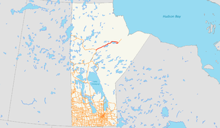
Provincial Trunk Highway 17 is a provincial highway in the Canadian province of Manitoba. It runs from an intersection with PR 325 near Hodgson to an intersection with PTH 9 near Gimli.

Provincial Road 392 (PR 392) is a provincial road in the Canadian province of Manitoba. It runs from an intersection with Highway 39 to an intersection at Poplar Avenue in Snow Lake. The route was first constructed in 1961, along with spurs to Osborne Lake and Chisel Lake. The route was designated in 1966, along with PR 393 and PR 395 running from the Canadian National Railway station at Wekusko to Snow Lake. The route was truncated in 1994 back to Highway 39 and the stretch from Highway 39 to Wekusko station was re-designated as PR 596.

Northern Woods and Water Route highway in Canada

The Northern Woods and Water Route is a 2,400-kilometre (1,500 mi) route through northern British Columbia, Alberta, Saskatchewan and Manitoba in Western Canada. As early as the 1950s community groups came together to establish a northern travel route; this was proposed as the Northern Yellowhead Transportation Route. The Northern Woods and Water Route Association was established in 1974, and encouraged promotion of the route with the promise of an increase in tourist travel. The route was designated in 1974 and is well signed throughout the connector highways. The route starts at Dawson Creek at the British Columbia Spirit River Highway 49 and ends at Winnipeg, Manitoba, running through the northern region of the western provinces. The Northern Woods and Water Route (NWWR) includes connector routes from west to east including British Columbia Highway 49, Alberta Highway 49, AB Hwy 2A, AB Hwy 2, AB Hwy 55, Saskatchewan Highway 55, SK Hwy 9, Manitoba Provincial Road 283, Manitoba Highway 10, MB PTH 5, MB PTH 68, MB PTH 6. The halfway point of the NWWR is approximately at Goodsoil, Saskatchewan.

Highway 12 is a major highway in the Canadian province of Saskatchewan. It begins in Saskatoon at the intersection of Idylwyld Drive and Highway 11 north, initially running north on Idylwyld Drive concurrently with Highway 11 and Highway 16. Just outside Saskatoon's northern city limits, Highway 11 exits northeast from Idylwyld Drive and Highway 12 begins and travels north, passing through the city of Martensville. Highway 12 cross the North Saskatchewan River over Petrofka Bridge and passes through the town of Blaine Lake and intersects highway Highway 40, finally terminating at Highway 3 near Shell Lake. Highway 12 is about 135 km (84 mi) long.

Highway 913 is a highway in the Canadian province of Saskatchewan. It runs from Highway 120 to Highway 106. Highway 106 is commonly called the Hanson Lake Highway. The southern terminus is 9.9 kilometers north of Candle Lake Provincial Park, and the north terminus is within the Narrow Hills Provincial Park and 15.2 kilometers north from the Narrow Hills Provincial Park campground area. Highway 913 is about 65.1 kilometres (40.5 mi) long. Highway 913 also connects with Highway 963. Traveling 41.2 kilometres is a concurrency with Highway 912 for 5 kilometres. Highway 913 is gravel its whole length.

Provincial Road 399 (PR 399) is a provincial road in the Canadian province of Manitoba. It runs from PR 391 in Lynn Lake to PR 397 in Lynn Lake. The route was designated in 1966 as part of a mass numbering of roads through the northern part of the province.

Manitoba Provincial Road 280 highway in Manitoba

Provincial Road 280 (PR 280) is a road in the Canadian province of Manitoba. It runs from PR 391 northwest of Thompson to local streets in Gillam. The route is 291 kilometres (181 mi) long, which during its length, passes several large lakes and intersects with one provincial road, PR 290, just north of Gillam. The route is very scenic, passing through dense forests and rural lands. The route supplies three municipalities, Thompson, Split Lake, and Gillam. From its terminus north of Thompson, Manitoba to the town Gillam, PR 280 is classified as a Class A1 Provincial Route.

Provincial Road 290 is a provincial road in the Canadian province of Manitoba. PR 290 begins at an intersection with Manitoba Provincial Road 280 in Jacam and heads to the northeast towards the abandoned town of Sundance. Most of PR 290's length is in a dense forest in northern Manitoba.

Provincial Road 373 is a highly recognized all-weather provincial road in Division 22 of Manitoba. The road was made famous by a group of singers from Norway House, who named their band Highway 373. PR 373 begins at an intersection with Highway 6 in Setting Lake, heads eastward through rural regions, and terminating at an intersection with local roads in Norway House. There is one major intersection along the way, Road 374, which heads north to Cross Lake. PR 373's entire length is declared a class A1 provincial road.

Manitoba Provincial Road 366 highway in Manitoba

Provincial Road 366 is a provincial road in the Canadian province of Manitoba.

Manitoba Provincial Road 355 is an east-west provincial road in the southwestern section of the Canadian province of Manitoba.

Manitoba Provincial Road 350 is a provincial road in the south-central section of the Canadian province of Manitoba.

Manitoba Provincial Road 263 is a former provincial road in the Canadian province of Manitoba.

Provincial Road 374 is a 39-kilometre-long (24 mi) provincial highway in northeastern Manitoba. A spur of PR 373 southeast of Jenpeg, PR 374 runs to Cross Lake, which connects to local streets and the Cross Lake First Nation. The route also crosses over the Kichi Sipi Bridge, which spans over the Nelson River since September 2004.

References

  1. 1 2 3 4 Google (April 11, 2015). "overview map of PR 394" (Map). Google Maps . Google. Retrieved April 11, 2015.
  2. 1 2 Manitoba Highway Map (PDF) (Map). Manitoba Minister of Infrastructure and Transportation. 1966. Retrieved March 5, 2015.
  3. Manitoba Highway Map (PDF) (Map). Manitoba Minister of Infrastructure and Transportation. 1961. Retrieved April 11, 2015.
  4. Manitoba Highway Map (PDF) (Map). Manitoba Minister of Infrastructure and Transportation. 1962. Retrieved April 11, 2015.
  5. Manitoba Highway Map (PDF) (Map). Manitoba Minister of Infrastructure and Transportation. 1963. Retrieved April 11, 2015.