
Kütahya Province is a province in the Aegean region of Turkey. It is 11,875 km2 in size, and the population is 571,554 (2014). In 1990, Kütahya had a population of 578,000.

Kulpin is a village in Serbia. It is situated in the Bački Petrovac municipality, in the South Bačka District, Vojvodina province. According to the 2002 census, the population of the village numbering 2,976 people, of whom 2,116 are ethnic Slovaks.
Sverdlov is a village in the Lori Province of Armenia.

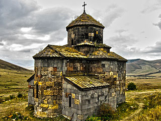
Tsaghkashen is a village in the Gegharkunik Province of Armenia, founded in 1859. The village church dedicated to S. Hovhannes dates to the 9th-10th century.
Wólka is a village in the administrative district of Gmina Szczuczyn, within Grajewo County, Podlaskie Voivodeship, in north-eastern Poland.
Starościn is a village in the administrative district of Gmina Kamionka, within Lubartów County, Lublin Voivodeship, in eastern Poland.
Grabówka is a village in the administrative district of Gmina Borzechów, within Lublin County, Lublin Voivodeship, in eastern Poland.
Kita is a small village in the administrative district of Gmina Złoczew, within Sieradz County, Łódź Voivodeship, in central Poland.
Uników is a village in the administrative district of Gmina Złoczew, within Sieradz County, Łódź Voivodeship, in central Poland. It lies approximately 5 kilometres (3 mi) west of Złoczew, 27 km (17 mi) south-west of Sieradz, and 77 km (48 mi) south-west of the regional capital Łódź.

Maciejów is a village in the administrative district of Gmina Słaboszów, within Miechów County, Lesser Poland Voivodeship, in southern Poland. It lies approximately 6 kilometres (4 mi) west of Słaboszów, 14 km (9 mi) east of Miechów, and 43 km (27 mi) north-east of the regional capital Kraków.
Gabrielnia is a village in the administrative district of Gmina Końskie, within Końskie County, Świętokrzyskie Voivodeship, in south-central Poland. It lies approximately 8 kilometres (5 mi) west of Końskie and 43 km (27 mi) north-west of the regional capital Kielce.
Szabelnia is a village in the administrative district of Gmina Końskie, within Końskie County, Świętokrzyskie Voivodeship, in south-central Poland. It lies approximately 8 kilometres (5 mi) west of Końskie and 43 km (27 mi) north-west of the regional capital Kielce.
Helenów Słupski is a village in the administrative district of Gmina Szczawin Kościelny, within Gostynin County, Masovian Voivodeship, in east-central Poland.
Mokrus is a village in the administrative district of Gmina Obryte, within Pułtusk County, Masovian Voivodeship, in east-central Poland.
Gać Kaliska is a village in the administrative district of Gmina Koźminek, within Kalisz County, Greater Poland Voivodeship, in west-central Poland.
Piła is a settlement in the administrative district of Gmina Wronki, within Szamotuły County, Greater Poland Voivodeship, in west-central Poland.
Poganowo is a former village in the administrative district of Gmina Kętrzyn, within Kętrzyn County, Warmian-Masurian Voivodeship, in northern Poland. It lies approximately 7 kilometres (4 mi) south of Kętrzyn and 65 km (40 mi) north-east of the regional capital Olsztyn.

Brestovac is a village in the municipality of Negotin, Serbia. According to the 2002 census, the village has a population of 355 people.
Põlluküla was a village in Lääne-Saare Parish, Saare County in western Estonia.

Đurakovo is a village in the municipality of Veliko Gradište, Serbia. According to the 2002 census, the village has a population of 338 people.
