Marbach am Neckar

Last updated
Marbach am Neckar
Geburtshaus Friedrich Schiller in Marbach.JPG
Friedrich Schiller's birthplace
DEU Marbach am Neckar COA.svg
Location of Marbach am Neckar within Ludwigsburg district
Marbach im Landkreis Ludwigsburg.pngMurrMurrHemmingen
Germany adm location map.svg
Red pog.svg
Marbach am Neckar
Baden-Wuerttemberg location map.svg
Red pog.svg
Marbach am Neckar
Coordinates: 48°56′N9°15′E / 48.933°N 9.250°E / 48.933; 9.250
Country Germany
State Baden-Württemberg
Admin. region Stuttgart
District Ludwigsburg
Government
   Mayor Jan Trost
Area
  Total18.06 km2 (6.97 sq mi)
Elevation
224 m (735 ft)
Population
 (2021-12-31) [1]
  Total15,797
  Density870/km2 (2,300/sq mi)
Time zone UTC+01:00 (CET)
  Summer (DST) UTC+02:00 (CEST)
Postal codes
71672
Dialling codes 07144
Vehicle registration LB
Website www.schillerstadt-marbach.de

Marbach am Neckar is a town about 20 kilometres north of Stuttgart. It belongs to the district of Ludwigsburg, the Stuttgart region and the European metropolitan region of Stuttgart. Marbach is known as the birthplace of Friedrich Schiller, to whom it owes the additional designation of Schiller City, which it has officially held since 2022.[2] The town is home to the Schiller National Museum, the German Literature Archive and the Modern Literature Museum.

Contents

Geography

Geographical location

Marbach is located in the Neckar Basin on the eastern bank of a loop of the Neckar, whose impact slope is interrupted by two deep cuts. The northern of the two cuts is flowed through by the largely blocked Strenzelbach stream, the southern by the Eichgraben ditch. Marbach's old town lies on the southern slope of the Strenzelbach valley, some 30 metres above the Neckar, while the newer residential and commercial areas are spread across the slopes further to the north-east, east and south. Even further south, somewhat secluded by the cutting of the Eichgraben, is the residential area of Hörnle with about 1600 inhabitants. The furrow formed by the Strenzelbach cuts short a loop of the Murr, which flows into the Neckar just north of the town, and forms an important traffic axis for Marbach and the surrounding area.

Districts and exclaves

In addition to the immediate surroundings of the Inner City, the urban area includes a narrow strip extending southwest along the Neckar River and incorporating the Marbach power plant.

Furthermore, three exclaves belong to the urban area. Two of them are the districts of Rielingshausen and Siegelhausen, both of which are spatially separated from Marbach. While the area of the core town itself is almost free of forest, the largest part of the forest area of Marbach comprises the uninhabited exclave in the Hardtwald to the north-east of the district of Rielingshausen, which is assigned to the Schwäbisch-Fränkische Waldberge natural area.

Rielingshausen, with about 2800 inhabitants, is located about five kilometres northeast of Marbach on a hill between the Murr and the Hardtwald. The hamlet of Hinterbirkenhof, one and a half kilometres to the north, also belongs to the village. The district is divided by several stream valleys, all of which lead to the Murr. The village centre lies in the shallow hollow of the Weidenbach, while the Kaisersbach forms a depression between Rielingshausen and Hinterbirkenhof. The eastern boundary of the village is formed by the Eichbach, which disappears halfway through in a sinkhole. The Sulzbach flows through a wide valley southeast of the village. After being straightened during the land consolidation in the 1970s, it was renaturalised at the end of the 1980s. This measure was awarded the cultural landscape prize of the Swabian Heritage Society in 1991.

Siegelhausen, a small hamlet with about 30 inhabitants, is located about five kilometres southeast of the core town off the road between Affalterbach and Hochdorf in the valley of the Strombach, which is also called the Apfelbach.

History

Marbach am Neckar was founded by the Franks in the 8th century AD between the Duchies of Swabia and Franconia and the Prince-Bishoprics of Speyer and Constance. Marbach received its town rights in 1009 from Walter Marktrecht, Bishop of Speyer. Around the mid-13th century, those rights were reaffirmed by the Dukes of Teck. In 1302, the Dukes of Teck sold Marbach to the County of Württemberg, who made the city the seat of its own administrative district later in the 14th century and then an Oberamt, Oberamt Marbach  [ de ], in 1758. That Oberamt was dramatically enlarged on 18 March 1806, but then dissolved entirely in 1938. Marbach was subsequently assigned to a new district, Landkreis Ludwigsburg. On 1 July 1972, Marbach incorporated the town of Rielingshausen. [2]

Geography

The city ( Stadt ) of Marbach am Neckar covers 18.06 square kilometers (6.97 sq mi) of the district of Ludwigsburg in a total of four separate exclaves. Marbach is, according to government urban planning, part of the Stuttgart Metropolitan Region. Marbach's municipal areas are physically located in the basin of  [ de ] the Neckar, with the exception of its easternmost exclave, which lies in the Swabian-Franconian Forest. The lowest elevation above sea level in the municipal area, 190 meters (620 ft) Normalnull (NN), is found where the Neckar flows out of Marbach and into Benningen am Neckar. The highest elevation, 355 meters (1,165 ft), is found in the east, at the top of the Bülzberg. [2]

Politics

Marbach has two boroughs (Ortsteile) – Marbach am Neckar and Rielingshausen – and three villages: Hinterbirkenhof, Hörnle, Siegelhausen. Also in Marbach's municipal area are the minor administrative units of Dampfkraftwerk, Eichgraben, and Häldenmühle, and the abandoned villages of Hegnachsiedel, Kaisersberg, and Sigebotesbuch. [2]

Sister cities

Marbach am Neckar is twinned with:

Coat of arms

DEU Marbach am Neckar COA.svg

Marbach am Neckar's coat of arms displays its field, gold in color, as divided party per pale into halves. The left half has three black stag antlers  [ de ], taken from the arms of Württemberg. The right half has a crenelated, white tower wrapped with green vines growing two clusters of blue grapes. The placement of Württemberg's arms is derived from town seals in since Württemberg's purchase of the city in 1302, when their arms replaced those of the Dukes of Teck. The tower first appeared around 1547 as a reference to local viticulture. The current coat of arms was devised in 1938 from a 1593 town seal. Marbach has had a municipal flag since 1871. [2]

Notable people

Friedrich Schiller, 1793 Friedrich Schiller by Ludovike Simanowiz.jpg
Friedrich Schiller, 1793

Sport

See also

Related Research Articles

Landkreis Heilbronn is a Landkreis (district) in the north of Baden-Württemberg, Germany. Neighboring districts are Neckar-Odenwald, Hohenlohe, Schwäbisch Hall, Rems-Murr, Ludwigsburg, Enz, Karlsruhe and Rhein-Neckar. In the centre of it is the free-city of Heilbronn, which is its own separate administrative area.

Esslingen is a Landkreis (district) in the centre of Baden-Württemberg, Germany. Neighboring districts are Rems-Murr, Göppingen, Reutlingen, Böblingen and the district-free city Stuttgart.

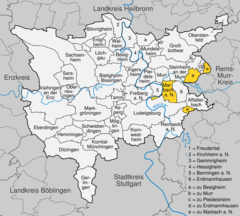
Landkreis Ludwigsburg is a Landkreis (district) in the middle of Baden-Württemberg, Germany. Neighboring districts are Heilbronn, Rems-Murr-Kreis, the district-free city Stuttgart, and the districts Böblingen and Enz-Kreis.

<span class="mw-page-title-main">Ludwigsburg</span> Town in Baden-Württemberg, Germany

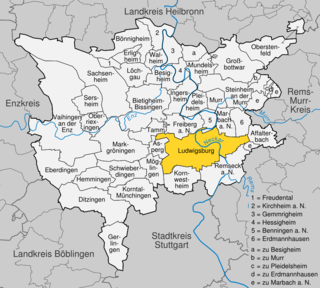
Ludwigsburg is a city in Baden-Württemberg, Germany, about 12 kilometres (7.5 mi) north of Stuttgart city centre, near the river Neckar. It is the largest and primary city of the Ludwigsburg district with about 88,000 inhabitants. It is situated within the Stuttgart Region, and the district is part of the administrative region (Regierungsbezirk) of Stuttgart.

<span class="mw-page-title-main">Fellbach</span> Town in Baden-Württemberg, Germany

Fellbach is a mid-sized town on the north-east edge of Stuttgart in Baden-Württemberg, Germany. With a population of approximately 45.430 as of December 2020 is the second largest town in the District Rems-Murr-Kreis. The area of the town is 27.7 km2 (10.7 sq mi).

<span class="mw-page-title-main">Affalterbach</span> German municipality

Affalterbach is a municipality in the Ludwigsburg district in Baden-Württemberg, Germany.

<span class="mw-page-title-main">Murr (river)</span> River in Germany

The Murr is a river in Baden-Württemberg, Germany, right tributary of the Neckar. The river gave its name to a small town on its banks, Murr, and to the Rems-Murr-Kreis district, which was also named after the river Rems, which runs roughly parallel to the south of the Murr.

<span class="mw-page-title-main">Kirchheim unter Teck</span> Town in Baden-Württemberg, Germany

Kirchheim unter Teck is a town in Baden-Württemberg, Germany, in the district of Esslingen. It is located on the small river Lauter, a tributary of the Neckar. It is 10 km near the Teck castle, approximately 35 kilometres southeast of Stuttgart. It is the fourth city in the Esslingen district, forming a district centre for the surrounding communities.

<span class="mw-page-title-main">Weinstadt</span> Town in Baden-Württemberg, Germany

Weinstadt is a town in the Rems-Murr district, in the state of Baden-Württemberg, Germany. It is located in the Rems Valley approximately 15 km east of Stuttgart. Its population in 2012 was 25,998.

<span class="mw-page-title-main">Ebersbach an der Fils</span> German city

Ebersbach is a town in the district of Göppingen in Baden-Württemberg, in southern Germany.

<span class="mw-page-title-main">Freiberg am Neckar</span> Town in Baden-Württemberg, Germany

Freiberg am Neckar is a town in the district of Ludwigsburg, Baden-Württemberg, Germany. It is situated on the left bank of the Neckar, 18 km north of Stuttgart, and 4 km north of Ludwigsburg.

<span class="mw-page-title-main">Beilstein, Württemberg</span> Town in Baden-Württemberg, Germany

Beilstein is a town in the district of Heilbronn in Baden-Württemberg in southern Germany. It is 14 kilometres (9 mi) southeast of Heilbronn. Beilstein is on the Württemberg wine route.

<span class="mw-page-title-main">Dornhan</span> Town in Baden-Württemberg, Germany

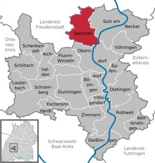
Dornhan is a town in the district of Rottweil, in Baden-Württemberg, Germany. It is situated in the eastern Black Forest, 14 km southeast of Freudenstadt.

<span class="mw-page-title-main">Murr, Baden-Württemberg</span> Municipality in Baden-Württemberg, Germany

Murr is a municipality in the district of Ludwigsburg, Baden-Württemberg, Germany. It is situated on the river Murr, 2 km upstream from its confluence with the Neckar and about 9 km northeast of Ludwigsburg.

<span class="mw-page-title-main">Erdmannhausen</span> German municipality

Erdmannhausen is a town in the district of Ludwigsburg in Baden-Württemberg in Germany.

<span class="mw-page-title-main">Erligheim</span> German municipality

Erligheim is a municipality in the district of Ludwigsburg in Baden-Württemberg in Germany.

<span class="mw-page-title-main">Ingersheim</span> Municipality in Baden-Württemberg, Germany

Ingersheim is a municipality in the district of Ludwigsburg in Baden-Württemberg in Germany, belonging to the Stuttgart Region.

<span class="mw-page-title-main">Oberstenfeld</span> Municipality in Baden-Württemberg, Germany

Oberstenfeld is a municipality in the district of Ludwigsburg in Baden-Württemberg in Germany. It is located about 40 km north of Stuttgart.

The Backnang–Ludwigsburg railway is a line on the northern edge of the Stuttgart region in the German state of Baden-Württemberg, linking Backnang and Ludwigsburg. The Backnang–Bietigheim line was opened in 1879 as a branch of the Murr Valley Railway from Waiblingen to Hessenthal and left the current route at Beihingen-Heutingsheim. The section between Beihingen-Heutingsheim and Bietigheim was damaged during the Second World War and was never returned to operation.

Großheppach is a town district or Stadtteil within the town of Weinstadt in Baden-Württemberg, Germany. The Stadtteil, which lies in the Rems Valley, is home to 4,398 residents. Großheppach and Kleinheppach are located along the Heppach, a small stream that flows into the river Rems. The village of Großheppach, the Weiler Gundelsbach, and the homestead Wolfshof belong to the Stadtteil, which has borders that exactly match those of the earlier municipality of Großheppach. Its neighbor Kleinheppach, on the other hand, is now part of the municipality of Korb.

References

  1. "Bevölkerung nach Nationalität und Geschlecht am 31. Dezember 2021" [Population by nationality and sex as of December 31, 2021](CSV) (in German). Statistisches Landesamt Baden-Württemberg. June 2022.
  2. 1 2 3 4 "Marbach am Neckar". LEO-BW (in German). Baden-Württemberg . Retrieved 31 July 2020.
  3. "L'Isle-Adam, Frankreich" (in German). City of Marbach am Neckar. Retrieved 31 July 2020.
  4. "Washington / Missouri, USA" (in German). City of Marbach am Neckar. Retrieved 31 July 2020.
  5. "Tongling, China" (in German). City of Marbach am Neckar. Retrieved 31 July 2020.
  6. Clerke, Agnes Mary (1911). "Mayer, Johann Tobias"  . Encyclopædia Britannica . Vol. 17 (11th ed.). p. 933.
  7. Robertson, John George (1911). "Schiller, Johann Christoph Friedrich von"  . Encyclopædia Britannica . Vol. 24 (11th ed.). pp. 324–326.