Nordwestmecklenburg is a Kreis (district) in the north-western part of Mecklenburg-Vorpommern, Germany. It is situated on the coast of the Baltic Sea and borders on Schleswig-Holstein to the west. Neighboring districts are Rostock, Ludwigslust-Parchim and the district-free city Schwerin, and the district Lauenburg and the district-free city Lübeck in Schleswig-Holstein. The district seat is the town Wismar.

Anglia is a small peninsula in northern Germany, on the Baltic coast of Jutland. Jutland consists of the mainland of Denmark and the northernmost German state of Schleswig-Holstein. Anglia belongs to the region of Southern Schleswig, which constitutes the northern part of Schleswig-Holstein. The region is often referred to in German as Landschaft Angeln or Halbinsel Angeln.

Göhl is a municipality in the district of Ostholstein, in Schleswig-Holstein, Germany.

Amt Neuhaus is a municipality in the District of Lüneburg, in Lower Saxony, Germany. Amt means "municipal office" in German. The original "municipal office of Neuhaus" existed since at least the 17th century until 1885, consecutively as part of Saxe-Lauenburg, Electorate of Hanover (1689-1810), Kingdom of Hanover (1814-1866), and the Prussian Province of Hanover (1866-1885).

Ellerbek is a municipality in the district of Pinneberg in Schleswig-Holstein in Germany. It consists of the two parts, Ellerbek-Dorf and Neu-Ellerbek.
Bosau is a municipality on the Great Plön Lake the district of Ostholstein, in Schleswig-Holstein, Germany. It is situated approximately 13 km west of Eutin, and 30 km southeast of the state capital of Kiel.

Gelting is a municipality in the district of Schleswig-Flensburg, in Schleswig-Holstein, Germany. It is situated near the Baltic Sea, approx. 33 km northeast of Schleswig, and 30 km east of Flensburg.

Hedwigenkoog is a municipality belonging to the Amt Büsum-Wesselburen in the district Dithmarschen in Schleswig-Holstein, Germany.
Westerdeichstrich is a municipality belonging to the Amt Büsum-Wesselburen in the district Dithmarschen in Schleswig-Holstein on the West Coast of Germany. It consists of the parts Westerdeichstrich, Groven, Augustenhof and Stinteck.

Dreschvitz is a municipality in southwest Vorpommern-Rügen, a district on the island of Rügen in Mecklenburg-Vorpommern, Germany. It is managed from the Amt of West-Rügen with its head offices in the village of Samtens.

Midlum is a municipality on the island of Föhr in the district of Nordfriesland, in Schleswig-Holstein, Germany.

Sylt-Ost is a former municipality on the island of Sylt, in the district of Nordfriesland, in Schleswig-Holstein, Germany. It used to be the administrative seat of the Amt Landschaft Sylt and a municipality into which a number of villages had been amalgamated in 1970. However, following a referendum in May 2008, Sylt-Ost merged with Westerland and Rantum to form the collective municipality Gemeinde Sylt which was created on 1 January 2009. Since 2009, the seat of the Amt Landschaft Sylt has been in Westerland.

Bokholt-Hanredder is a municipality in the district of Pinneberg, in Schleswig-Holstein, Germany. Bokholt-Hanredder consists of the four districts Voßloch, Bokholt, Hanredder and Offenau, which are symbolically represented in the coat of arms. The fox represents Voßloch, the Offenau creek separates the district of the same name from the rest of the municipality. One beech leaf each represents the remaining two districts, which takes into account the names Bokholt and Redder.

Hohwacht is a municipality in the district of Plön, in Schleswig-Holstein, Germany. It lies within the region of Wagria and its subordinate parishes are Hohwacht, Haßberg, Neudorf, Niedermühle and Schmiedendorf. The village was first mentioned in 1557 as Hohenwacht.
Osterby is a municipality in the district of Rendsburg-Eckernförde, in Schleswig-Holstein, Germany. It is mostly rural.

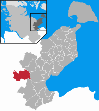
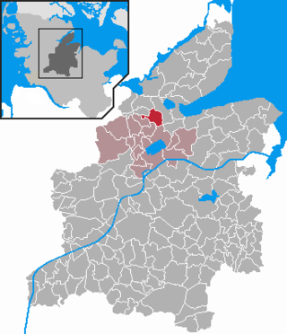
Krogaspe is a municipality in the district of Rendsburg-Eckernförde, in Schleswig-Holstein, Germany. Krogaspe is located north west of Neumünster close to Autobahn A7 and county highway 205 to Rendsburg.

Wasbek is a municipality, immediately west of Neumünster, in the district of Rendsburg-Eckernförde, in Schleswig-Holstein, Germany.

Westerrönfeld is a municipality in the district of Rendsburg-Eckernförde, in Schleswig-Holstein, Germany. The name literally means "The field west of the Rön", the Rön being a little tributary of the river Eider. Westerrönfeld is located on the southern bank of the Kiel Canal.

Travenbrück is a municipality in the district of Stormarn, in Schleswig-Holstein, Germany. The towns of Neverstaven, Nütschau, Schlamersdorf, Sühlen, Tralau and Vinzier are in the municipality.

Witzhave is a municipality in the district of Stormarn, in Schleswig-Holstein, Germany.


