Scott County is a county in the U.S. state of Minnesota. As of the 2020 census, the population was 150,928. Its county seat is Shakopee. Shakopee is also the largest city in Scott County, the twenty-third-largest city in Minnesota, and the sixteenth-largest Twin Cities suburb. The county was organized in 1853 and named in honor of General Winfield Scott. Scott County is part of the Minneapolis-St. Paul-Bloomington, MN-WI Metropolitan Statistical Area. It is a member of the Metropolitan Council, and shares many of the council's concerns about responsible growth management, advocating for progressive development concepts such as clustering, open-space design, and the preservation of open space and rural/agricultural land.

Hennepin County is a county in the U.S. state of Minnesota. Its county seat is Minneapolis, the state's most populous city. The county is named in honor of the 17th-century explorer Father Louis Hennepin. The county extends from Minneapolis to the suburbs and outlying cities in the western part of the county. The county’s natural areas are covered with extensive woods, hills, and lakes.
Prior Lake is an exurban city 20 miles (32 km) southwest of Minneapolis seated next to Savage and Shakopee in Scott County in the state of Minnesota. Surrounding the shores of Lower and Upper Prior Lake, the city lies south of the Minnesota River in an area known as RiverSouth and establishes the urban fringe of the south-southwest portion of Minneapolis-St. Paul, the sixteenth largest metropolitan area in the United States. The population of Prior Lake was 22,796 at the 2010 census.

Winfield Scott Hammond was an American politician. He was a member of the Democratic Party.

Marystown is a town in the province of Newfoundland and Labrador, Canada, with a population of around 5,000. Situated 306 km from the province's capital, St. John's, it is on the Burin Peninsula. Until the early 1990s, its economy was largely based on shipbuilding, and it is due in part to this that the town experienced a population increase of 295% in just over a decade. The town was also dependent on the fish plant for employment.
Webster is an unincorporated community in Webster Township, Rice County, Minnesota, United States.

Minnesota State Highway 282 (MN 282) is a 7.655-mile-long (12.320 km) highway in Minnesota, which runs from its intersection with U.S. Highway 169 in Jordan and continues east to its eastern terminus at its intersection with State Highway 13 in Spring Lake Township near Prior Lake.

Union Hill is an unincorporated community in Le Sueur and Scott counties in the U.S. state of Minnesota.

Shakopee is a city in and the county seat of Scott County, Minnesota, United States. It is located southwest of Minneapolis. Sited on the south bank bend of the Minnesota River, Shakopee and nearby suburbs comprise the southwest portion of Minneapolis-Saint Paul, the sixteenth-largest metropolitan area in the United States, with 3.7 million people. The population was 43,698 at the 2020 census.
Scotts Corner is an unincorporated community in Twin Lakes Township, Carlton County, Minnesota, United States; located near Wrenshall and Chub Lake.
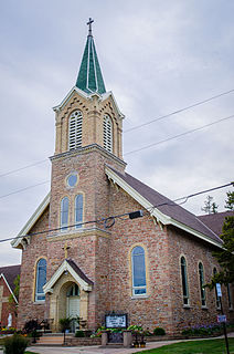
St. Mary's Church of the Purification in Marystown, Minnesota, United States, is a stone church building completed in 1882. The spire was finished in 1883, bringing the total cost of the new church to $8,246.62.
Lake Hubert is an unincorporated community in Lake Edward Township, Crow Wing County, Minnesota, United States. Lake Hubert is 2 miles (3.2 km) southeast of Nisswa. It is along Crow Wing County Road 13 near County Road 137. Lake Hubert has the ZIP code 56459.
Lydia is an unincorporated community in Spring Lake Township, Scott County, Minnesota, United States.
Helena is an unincorporated community in Scott County, Minnesota, United States.
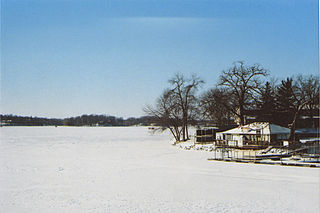
Blakeley is an unincorporated community in Blakeley Township, Scott County, Minnesota, United States, along the Minnesota River. The community is located west-southwest of Belle Plaine near the junction of Scott County Roads 1, 6, and 60.
St. Patrick is an unincorporated community in Cedar Lake Township, Scott County, Minnesota, United States.
Cedar Lake is an unincorporated community in Cedar Lake Township, Scott County, Minnesota, United States, near New Prague and Elko New Market. The community is located along Scott County Road 23 near 250th Street East.
Schley is an unincorporated community in Cass County, Minnesota, United States, within the Bowstring State Forest and the Chippewa National Forest. It is located between Cass Lake and Bena along U.S. Highway 2 near Forest Road 2958.