A municipality is usually a single administrative division having corporate status and powers of self-government or jurisdiction as granted by national and regional laws to which it is subordinate. It is to be distinguished (usually) from the county, which may encompass rural territory or numerous small communities such as towns, villages and hamlets.
A local government is a form of public administration which, in a majority of contexts, exists as the lowest tier of administration within a given state. The term is used to contrast with offices at state level, which are referred to as the central government, national government, or federal government and also to supranational government which deals with governing institutions between states. Local governments generally act within powers delegated to them by legislation or directives of the higher level of government. In federal states, local government generally comprises the third tier of government, whereas in unitary states, local government usually occupies the second or third tier of government, often with greater powers than higher-level administrative divisions.
In many countries, a mayor is the highest-ranking official in a municipal government such as that of a city or a town.

The municipalities of Brazil are administrative divisions of the Brazilian states. At present, Brazil has 5,570 municipalities, making the average municipality population 34,361. The average state in Brazil has 214 municipalities. Roraima is the least subdivided state, with 15 municipalities, while Minas Gerais is the most subdivided state, with 853.

In law, an unincorporated area is a region of land that is not governed by a local municipal corporation; similarly an unincorporated community is a settlement that is not governed by its own local municipal corporation, but rather is administered as part of larger administrative divisions, such as a township, parish, borough, county, city, canton, state, province or country. Occasionally, municipalities dissolve or disincorporate, which may happen if they become fiscally insolvent, and services become the responsibility of a higher administration. Widespread unincorporated communities and areas are a distinguishing feature of the United States and Canada. In most other countries of the world, there are either no unincorporated areas at all, or these are very rare; typically remote, outlying, sparsely populated or uninhabited areas.

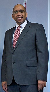
Letsie III is the current king of Lesotho. He succeeded his father, Moshoeshoe II, when the latter was forced into exile in 1990. His father was briefly restored in 1995 but soon died in a car crash in early 1996, and Letsie became king again. As a constitutional monarch, most of King Letsie's duties as monarch of Lesotho are ceremonial. In 2000, he declared HIV/AIDS in Lesotho to be a natural disaster, prompting immediate national and international response to the epidemic.
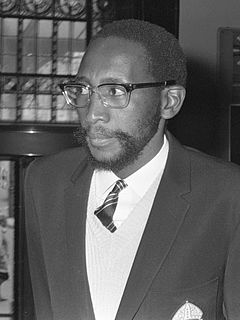
Moshoeshoe II, previously known as Constantine Bereng Seeiso, was the paramount chief of Lesotho, succeeding paramount chief Seeiso from 1960 until the country gained full independence from Britain in 1966. He was king of Lesotho from 1966 until his exile in 1990, and from 1995 until his death in 1996.

Halifax, formally known as the Halifax Regional Municipality (HRM), is the capital of the Canadian province of Nova Scotia. It had a population of 403,131 in 2016, with 316,701 in the urban area centred on Halifax Harbour. The regional municipality consists of four former municipalities that were amalgamated in 1996: Halifax, Dartmouth, Bedford, and Halifax County.

Mochudi is one of the larger villages in Botswana with a population of 44,815 people in 2011. It is situated in the Bakgatla tribal region, in Kgatleng District, about 37 km (23 mi) northeast of Gaborone. The village lies several kilometres from the main Gaborone–Francistown road, and can be accessed through a short turn at Pilane. Mochudi was settled by the Tswana people in 1871.

Kgatleng is one of the districts of Botswana, coterminous with the homeland of the Bakgatla people. Its capital is Mochudi, the hometown of protagonist Precious Ramotswe in Alexander McCall Smith's popular The No. 1 Ladies' Detective Agency series. According to the 2001 Census, Kgatleng had a population of 73,507 people.
Prince Seeiso Bereng Seeiso of Lesotho, Principal Chief of Matsieng is the younger brother of Lesotho's King Letsie III, and son of the Southern African country's, the late King Moshoeshoe II (1938–1996) and the late Queen 'Mamohato Bereng Seeiso (1941–2003).

Prince Lerotholi Seeiso is a member of the Royal Family of Lesotho and the current heir apparent to the throne.

Gabane is a village in Kweneng District of Botswana. It is located 15 km (10 mi) west of Gaborone, the capital of Botswana. The population was 10,399 in 2001 census, making it the fourth largest settlement in Kweneng. Its population was 14,842 at the 2011 census. It's now part of Gaborone agglomeration home to 421,907 inhabitants at the 2011 census.
Matsieng is a Setswana traditional music trio formed in 2005 in Gaborone Botswana. They burst into the scene with their 2005 festive season album, Semakaleng. Known for their explicit lyrics, the trio has toured Botswana, Malaysia and South Africa.

The Matsieng Footprints are engraved petroglyphs found in southern Botswana. Matsieng may have once been used as a ritual site for many peoples due to its role in local folktales. It shares its name with a character in African origin stories, Matsieng the great hunter. The site contains up to 117 engravings and three natural rock-holes, dating back between 3,000 to 10,000 years. Many of the footprints are human or feline-like in design.
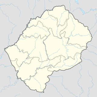
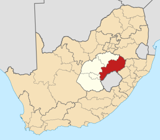
Makhoarane is a community council located in the Maseru District of Lesotho. Its population in 2006 was 26,674.
Matsieng Air Strip is a new general aviation airfield near Rasesa, 44 kilometres (27 mi) north of Gaborone, Botswana.