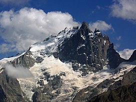
Summits
- Main ridge from west to east
- Le Grand Doigt, 3.764 m
- Pic du Glacier Carré, 3.862 m
- Grand Pic de la Meije or Pic Occidentale, 3.983 m
- Pic Central or Doigt de Dieu, 3.970 m
- Pic Oriental, 3.891 m
Neighboring peaks are Le Râteau (3,809 m) to the west, past the Brèche de la Meije (3,357 m) and fr:Le Pavé (3,823 m) and Pic Gaspard (3,881 m) to the southeast, past the Brèche Maximin Gaspard (3,723 m)
Historic ascents
The central and second highest summit has five teeth, the highest of which is known as Doigt de Dieu (English: Finger of God). This summit was reached from the northeast on June 28, 1870, by Christian and Ulrich Almer and Christian Gertsch, guiding Meta Brevoort and W.A.B. Coolidge. The ridge from the central to the main, Western peak, which is 13 meters higher, was considered an insurmountable obstacle for the next 15 years.
The Western true summit of La Meije, the Grand Pic, is notorious for having no "easy" route to its summit. The last major peak in the Alps to be climbed, its first ascent was eventually made from the southwest on 16 August 1877 by father and son Pierre Gaspard and their client Emmanuel Boileau de Castelnau. [1] Their approach, over the south buttress Arête du Promontoire and further over the Glacier Carré and the southwest face of the Grand Pic, is now the normal route.
The first ascent without a guide was made by Frederick Gardiner with Charles and Lawrence Pilkington on 25 July 1879. [2] [3]
On July 26, 1885, Ludwig Purtscheller and the brothers Otto and Emil Zsigmondy made the first traverse from the central to the main summit, [1] via the "insurmountable" gap that is now known as the Brèche Zsigmondy, in what is still considered a classic route, albeit thoroughly modified by a May 1964 rockfall. The traverse in the opposite direction was accomplished six years later by Ulrich Almer, Fritz Boss and John Henry Gibson. [4] [5]
The south face is widely considered to be the most difficult of La Meije. Within two weeks after their successful traverse, the Zsigmondy brothers, together with Karl Schulz, tried to reach the Brèche Zsigmondy over the south face, but Emil died in the attempt. [1] The first successful attempt was not until twenty-seven years later, in 1912 by Angelo Dibona, Luigi Rizzi, and the brothers Guido and Max Mayer, while a direct route over the south face to the Grand Pic was only climbed in 1935 and that to the Central Pic in 1951. [6]
This page is based on this
Wikipedia article Text is available under the
CC BY-SA 4.0 license; additional terms may apply.
Images, videos and audio are available under their respective licenses.