Melrose, New Zealand

Last updated

Melrose
Cook Strait from Melrose, Wellington.jpg
Cook Strait from Melrose
Melrose, New Zealand
Country New Zealand
City Wellington City
Electoral wardMotukairangi/Eastern Ward
Area
[1]
  Land33 ha (82 acres)
Population
 (June 2022) [2]
  Total1,350
Newtown Kilbirnie
Berhampore
Pfeil oben.svg
Pfeil links.svgMelrosePfeil rechts.svg
Pfeil unten.svg
Rongotai
Island Bay Southgate Lyall Bay

Melrose is a suburb of Wellington, New Zealand. It is south of the city centre, Berhampore and Newtown, and is in the Eastern Ward. Although adjacent to Lyall Bay, it does not have seafront access to the bay.

Contents

History

In 1879 the Melrose Estate was put up for auction. The land had belonged to Alexander Sutherland who died in 1877, and was sold to Mace and Jackson and then a syndicate known as Melrose Proprietors. Like James Coutts Crawford's subdivision of the Seatoun township on the Miramar Peninsula, there were few buyers because of difficult access. Crawford's earlier auction of Kilbirnie sections in 1874 had attracted mainly speculators buying cheap land rather than would-be homeowners. [3]

The Melrose Borough was established in 1888 from the earlier Kilbirnie Road Board, to serve a horseshoe-shaped and largely rural area stretching from Upland Farm (later Kelburn) through Brooklyn and Island Bay and to areas later called Haitaitai and Roseneath. Initially it was to be called the Borough of Southend. [4]

The borough experienced rapid growth from the early 1890s, mainly in Kilbirnie, Brooklyn and Island Bay. Amalgamation with Wellington City would avoid large borough debt for amenities like drainage, water supply and a separate electric tramway system. Wellington City was planning an electric tramway system to replace the private horse tramways, and purchased them in 1902 (the first electric line was opened in 1904). [5]

In June 1902 a poll of Melrose residents agreed to join the Wellington City Council, and amalgamation proceeded in 1903. Extension of new electric tramway to the area plus water supply and sewerage was promised within three years, although held up by Island Bay "malcontents" wanting a firm commitment of a tramway extension to Island Bay. [6]

There was a "boom" in house construction in Melrose and Kilbirnie in 1907. [7]

In 2013 the population reached 1,215 in the 34-hectare (84-acre) land area. [8]

The Wellington ward boundaries split Melrose between the Motukairangi/Eastern Ward and the Paekawakawa/ Southern Ward. [9]

Demographics

Melrose statistical area covers 0.33 km2 (0.13 sq mi). [1] It had an estimated population of 1,350 as of June 2022, [2] with a population density of 4,091 people per km2.

Historical population
YearPop.±% p.a.
20061,182    
20131,212+0.36%
20181,299+1.40%
Source: [10]

Melrose had a population of 1,299 at the 2018 New Zealand census, an increase of 87 people (7.2%) since the 2013 census, and an increase of 117 people (9.9%) since the 2006 census. There were 492 households. There were 660 males and 642 females, giving a sex ratio of 1.03 males per female. The median age was 35.2 years (compared with 37.4 years nationally), with 204 people (15.7%) aged under 15 years, 315 (24.2%) aged 15 to 29, 687 (52.9%) aged 30 to 64, and 93 (7.2%) aged 65 or older.

Ethnicities were 85.9% European/Pākehā, 9.2% Māori, 5.5% Pacific peoples, 7.2% Asian, and 3.9% other ethnicities (totals add to more than 100% since people could identify with multiple ethnicities).

The proportion of people born overseas was 30.0%, compared with 27.1% nationally.

Although some people objected to giving their religion, 64.9% had no religion, 23.1% were Christian, 1.6% were Hindu, 0.9% were Muslim, 0.9% were Buddhist and 3.2% had other religions.

Of those at least 15 years old, 543 (49.6%) people had a bachelor or higher degree, and 60 (5.5%) people had no formal qualifications. The median income was $46,900, compared with $31,800 nationally. The employment status of those at least 15 was that 690 (63.0%) people were employed full-time, 165 (15.1%) were part-time, and 39 (3.6%) were unemployed. [10]

Notable Features

Mount Albert

Mount Albert serves as a water distribution location to the surrounding suburbs from the Mt Albert reservoir. [11] In 2016 the original 1910 810 litre tank was replaced with a 2.2 million litre tank built underground beside another above ground tank built in 1955.

The Wellington town belt reserve runs along the top of Melrose, backing on to the Wellington Zoo logical gardens. Mt Albert is part of this reserve and includes biking and walking opportunities along the Southern walkway. [12] There is an off-leash dog exercise area part way up Mt Albert and a specialised mountain biking track has been built in the reserve by local volunteers.

Melrose Park

Melrose Park is located on Sutherland Crescent. Football is played here, there is an artificial surface for cricket and the park also contains a playground and changing rooms. [13]

Truby King House

Truby King house Truby King house (2391708694).jpg
Truby King house

Truby King Park is off Manchester Street in Melrose, the homestead is now managed by Wellington City Council but was previously home to the founder of the Plunket Society and features many plaques and memorials to the work Sir Truby King and his wife Lady Isabella King undertook. [14] Both are interred at a mausoleum on the 1.4-hectare (3.5-acre) site.

Activities

The Melrose suburb is part of the Predator Free Lyall Bay, Rongatai and Melrose group. [15] Through backyard trapping, this group aims to help New Zealand native species become reestablished within Wellington.

Related Research Articles

<span class="mw-page-title-main">Eastbourne, New Zealand</span> Place in Wellington Region, New Zealand

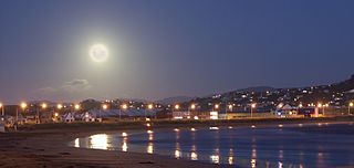
Eastbourne is a suburb of Lower Hutt, a part of Wellington, New Zealand. Lying beside the sea, it is a popular local tourist destination via car from Petone or from ferry crossings from central Wellington. An outer suburb, it lies on the eastern shore of Wellington Harbour, five kilometres south of the main Lower Hutt urban area and directly across the harbour from the Miramar Peninsula in Wellington city. A narrow exposed coastal road connects it with the rest of Lower Hutt via the Eastern Bays and the industrial suburb of Seaview. It is named for Eastbourne in England, another seaside town known as a destination for day-trips.

<span class="mw-page-title-main">Kapiti Coast District</span> South-western section of the coast of North Island, New Zealand

The Kapiti Coast District is a local government district of the Wellington Region in the lower North Island of New Zealand, 50 km north of Wellington City. The district is named after Kapiti Island, a prominent island 5 kilometres (3.1 mi) offshore.

<span class="mw-page-title-main">Wellington City Council</span> Territorial authority in the Wellington urban area of New Zealand

Wellington City Council is a territorial authority in New Zealand, governing the country's capital city Wellington, and de facto second-largest city. It consists of the central historic town and certain additional areas within the Wellington metropolitan area, extending as far north as Linden and covering rural areas such as Mākara and Ohariu. The city adjoins Porirua in the north and Hutt City in the north-east. It is one of nine territorial authorities in the Wellington Region.

<span class="mw-page-title-main">Kelburn, New Zealand</span> Suburb in Wellington City, New Zealand

Kelburn is a central suburb of Wellington, the capital city of New Zealand, situated within 1 kilometre (0.62 mi) of the central business district.

<span class="mw-page-title-main">Miramar, New Zealand</span> Suburb in Wellington City, New Zealand

Miramar is a suburb of Wellington, New Zealand, south-east of the city centre. It is on the Miramar Peninsula, directly east of the isthmus of Rongotai, the site of Wellington International Airport.

<span class="mw-page-title-main">Miramar Peninsula</span> Land in Wellington city, New Zealand

The large Miramar Peninsula is on the southeastern side of the city of Wellington, New Zealand, at the entrance to Wellington Harbour, in Wellington's eastern suburbs. According to Māori legend, it was formed when the taniwha Whaitaitai beached as he tried to escape the confines of the harbour. It contains the suburb of Miramar.

<span class="mw-page-title-main">Hataitai</span> Suburb in Wellington City, New Zealand

Hataitai is an inner-city suburb of Wellington, the capital of New Zealand, 3.5 kilometres southeast of the city centre. The suburb extends over the southeastern flank of Mount Victoria and down a valley between the Town Belt and a ridge along the shoreline of Evans Bay. Hataitai is bounded by Hepara Street, Grafton Road and the suburb of Roseneath in the north, Wellington Harbour in the east, Cobham Drive, Wellington Road and Crawford Road in the south, and Alexandra Road in the west.

<span class="mw-page-title-main">Khandallah</span> Suburb of Wellington, New Zealand

Khandallah is a suburb of Wellington, the capital city of New Zealand. It is located 4 kilometres (2.5 mi) northeast of the city centre, on hills overlooking Wellington Harbour.

<span class="mw-page-title-main">Ngaio, New Zealand</span> Suburb in Wellington City, New Zealand

Ngaio is an inner suburb of Wellington, the capital city of New Zealand. It is situated on the slopes of Mount Kaukau, 3500 metres north of the city's CBD. It was settled in the 1840s and many of its streets are named after early settler families. Ngaio was originally a logging community known first as Upper Kaiwarra, then as Crofton until 1908. The area was administratively part of a separate local authority called the Onslow Borough Council which amalgamated with Wellington City in 1919.

<span class="mw-page-title-main">Wellington tramway system</span>

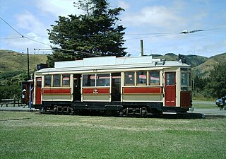
The Wellington tramway system (1878–1964) operated in Wellington, the capital of New Zealand. The tramways were originally owned by a private company, but were purchased by the city and formed a major part of the city's transport system.

<span class="mw-page-title-main">Houghton Bay</span> Suburb in Wellington City, New Zealand

Houghton Bay and Valley is one of the southern suburbs of Wellington, New Zealand. It is located between Island Bay and Lyall Bay, on the rocky shores of the Cook Strait. It has two beaches, Houghton Bay and Princess Bay, used by surfers, swimmers and divers.

<span class="mw-page-title-main">Lyall Bay</span> Suburb in Wellington City, New Zealand

Lyall Bay is a bay and suburb on the south side of the Rongotai isthmus in Wellington, New Zealand.

<span class="mw-page-title-main">Rongotai</span> Suburb in Wellington City, New Zealand

Rongotai is a suburb of Wellington, New Zealand, located southeast of the city centre. It is on the Rongotai isthmus, between the Miramar Peninsula and the suburbs of Kilbirnie and Lyall Bay. It is known mostly for being the location of the Wellington International Airport. It is roughly in the centre of the Rongotai electorate, which is much bigger than the suburb.

<span class="mw-page-title-main">Trolleybuses in Wellington</span>

Trolleybuses in Wellington were part of the Wellington public transport system from 1924 until 1932 and again from 1949 until 2017. It was the last trolleybus system operating commercially in Oceania and the last major system operating in a country where driving is on the left side of the road.

<span class="mw-page-title-main">Kilbirnie, New Zealand</span> Suburb in Wellington City, New Zealand

Kilbirnie is a suburb of Wellington in New Zealand, 3 kilometres (1.9 mi) to the south-east of the city centre. Travellers can reach Kilbirnie from the Wellington central business district via the Mount Victoria Tunnel and Hataitai, or over Mount Victoria, or around the coast.

<span class="mw-page-title-main">Newtown, New Zealand</span> Suburb in Wellington City, New Zealand

The suburb of Newtown lies in the southern part of Wellington in New Zealand. It lies east of Vogeltown, between Mount Cook and Berhampore. The main thoroughfares of Newtown are Riddiford St, leading from Mount Cook to Berhampore and Melrose, and Constable St, leading from Newtown to Kilbirnie.

<span class="mw-page-title-main">Wadestown, New Zealand</span> Suburb in Wellington City, New Zealand

Wadestown is a northern suburb of Wellington, located about 2–3 km by road from the Wellington central business district and the New Zealand Parliament Buildings.

<span class="mw-page-title-main">Evans Bay, New Zealand</span> Bay in Wellington, New Zealand

Evans Bay, located in Wellington Harbour, New Zealand, between the Miramar Peninsula and Hataitai, was the site of New Zealand's first patent slip and served as Wellington's international flying-boat terminal from 1938 until 1956. It is named after George Samuel Evans, an early Wellington settler.

<span class="mw-page-title-main">Maupuia</span> Suburb in Wellington City, New Zealand

Maupuia on the Miramar Peninsula is an eastern suburb of Wellington to the north-west of Miramar. Developed in the 1970s, it is in the Eastern Ward.

The Karitane Hospitals were six hospitals in New Zealand run by the Plunket Society, located in Auckland, Christchurch, Dunedin, Invercargill, Wanganui and Wellington. They were established as training hospitals for Karitane nurses and cared for babies with malnutrition and other dietetic complaints, and premature babies. They also offered mother care training and assistance. The first hospital opened in 1907 and the hospitals were closed between 1978 and 1980 due to financial difficulties and changes in society and maternity services.

References

  1. 1 2 "ArcGIS Web Application". statsnz.maps.arcgis.com. Retrieved 1 July 2021.
  2. 1 2 "Population estimate tables - NZ.Stat". Statistics New Zealand . Retrieved 25 October 2022.
  3. Humphris & Mew 2009, p. 48.
  4. Humphris & Mew 2009, p. 57.
  5. Humphris & Mew 2009, p. 63.
  6. Humphris & Mew 2009, p. 65.
  7. Humphris & Mew 2009, p. 103.
  8. "About the profile areas | Melrose | profile.id". profile.idnz.co.nz. Retrieved 10 November 2019.
  9. "Wellington Election Wards" (PDF). Wellington City Council.
  10. 1 2 "Statistical area 1 dataset for 2018 Census". Statistics New Zealand. March 2020. Melrose (253900). 2018 Census place summary: Melrose
  11. "CuriousCity: Where Wellington stores its water". Stuff. Retrieved 10 November 2019.
  12. "Mount Albert". Wellington City Council. Retrieved 10 November 2019.
  13. "Locations". Wellington City Council. Retrieved 10 November 2019.
  14. "Truby King Park". Wellington Gardens. Retrieved 10 November 2019.
  15. "Nearly 35,000 rats, weasels, possums and stoats trapped in Wellington as community pitches in". TVNZ. Retrieved 10 November 2019.

Further reading

Coordinates: 41°19′21″S174°47′20″E / 41.32250°S 174.78889°E / -41.32250; 174.78889