Lyall Bay

Last updated

Lyall Bay
Huetepara (Māori) [1]
FullMoonOverLyallBay.jpg
Full moon over the bay
Lyall Bay
Coordinates: 41°19′48″S174°47′37″E / 41.329993°S 174.793505°E / -41.329993; 174.793505
CountryNew Zealand
City Wellington City
Local authority Wellington City Council
Electoral ward
  • Motukairangi/Eastern Ward
  • Te Whanganui-a-Tara Māori Ward
Area
[2]
  Land55 ha (136 acres)
Population
 (June 2023) [3]
  Total2,690
Airports Wellington International Airport
Kilbirnie Kilbirnie Rongotai
Melrose
Pfeil oben.svg
Pfeil links.svgLyall BayPfeil rechts.svg
Pfeil unten.svg
Rongotai
(Cook Strait) Moa Point

Lyall Bay is a bay and suburb on the south side of the Rongotai isthmus in Wellington, New Zealand.

Contents

The bay is a popular surf beach, featuring a breakwater at the eastern end. It is home to two surf lifesaving clubs and has also been the site of surf lifesaving championships. Lyall Bay is a very popular and safe swimming beach. [4] The beach is only two thirds of its original size: the construction of Wellington International Airport took away the eastern third of the beach. The suburb consists of most of the southern half of the Rongotai isthmus, although Wellington International Airport and a small industrial area next to it are often considered to be part of Rongotai. Lyall Bay is predominantly a residential area, but also contains a part of Wellington's Southern Walkway and the Southern Headlands Reserve. The suburb has a bus service and is near to the Kilbirnie shopping centre and the Tirangi Road Airport Retail Park. There is a primary school (Lyall Bay School), a Playcentre, a lawn bowls club, two churches and a small range of shops. The suburb is also home to Fat Freddy's Drop, a popular Wellington band. The south-western border has Te Raekaihau Point as the dividing landform to Houghton Bay.

View of Lyall Bay in the early 20th century View overlooking Lyall Bay. ATLIB 286536.png
View of Lyall Bay in the early 20th century

Lyall Bay was probably the ancient mouth of the Hutt River. [5] The current isthmus was created by geologic upheaval as a result of recurring earthquakes, notably the Haowhenua earthquake in the fifteenth century and the 1855 Wairarapa earthquake. [6] The 1855 earthquake caused a tsunami that swept over the isthmus between Lyall Bay and Evans Bay, leaving fish stranded amongst the sand dunes. [7]

Etymology

Lyall Bay was earlier known as False Bay, because ships would mistake the bay for the entrance to Wellington Harbour. [8] A Māori name for the beach was Hue te para, which literally means 'gourd' (hue), 'the' (te), and 'ripe' (para) [1] Writing in 1919, Elsdon Best stated that Hue te para appeared on a map drawn by Crawford but that none of the Māori he had spoken to knew of that name. [9]

Some believe that Lyall Bay is named after Dr David Lyall of the survey ship HMS Acheron, but he didn't serve on that ship until 1847, [10] by which time the name Lyall Bay was already in use. Another theory is that it is named after George Lyall, one of the directors of the New Zealand Company. [1] Early records also sometimes show the name as Lyell Bay and it has been claimed that it was named after geologist Charles Lyell. [11] [12]

History

The suburb of Lyall Bay was initially named Maranui by H D Crawford and H M Hayward, who began selling 80 sections for a new township at the bay in 1896. [13] Maranui School (now Lyall Bay School) opened in February 1909. [14] Progress of the suburb was slow until the City Council opened a tram line extension down Onepu Road to the beach In December 1909. [15] [16] This led to rapid development and an influx of day trippers at the weekends. [17]

Sand drift

Most development was at the western side of the suburb. The eastern side was mostly sand dunes, and the tramline was often blocked by drifting sand. Wellington City Council responded to the problem in 1925 with a programme to level the dunes and cover much of the area with a layer of clay to hold the sand in place. [18] [19] In 1932 the Council built the distinctive 'whirler' sea wall along the beach. [20] It was designed to blow sand back on to the beach instead of over the road.

Sand and gravel built up on the beach during 1939, and from the 1940s until the 1960s Wellington City Council paid contractors to remove it. [21] [22] The beach became severely eroded, with the level of the beach at the surf lifesaving clubhouses about 3 ft (1m) lower in 1961 than it had been previously and no beach remaining at high tide. [23] Residents blamed the removal of material from the beach and the construction of the breakwater at the airport end which had changed the currents in the bay. [24] The Council countered that sand and gravel was removed carefully and that the erosion was a natural process. Residents at the eastern end of the bay where there was no seawall also suffered from sand drifting across the road, so in 1975 the Council built a seawall eastwards from Onepu Road. [25] [26]

From 1990, Wellington City Council began a programme of sand dune restoration at the eastern end of Lyall Bay beach. Part of the dune was fenced off and boardwalks constructed for access to the beach through the dune. Thousands of pingao and other plants were planted to hold the sand in place. [27]

Reclamation for airport

In December 1935 Wellington City Council approved Rongotai aerodrome as the site of an airport suitable for all types of aircraft, which would have involved reclamation of 26 acres (10.5 hectares) of seabed at the eastern end of Lyall Bay. [28] [29] Some reclamation took place in Lyall Bay in 1940 with spoil from Moa Point Hill. [30] After further discussion a plan was released in 1944 which would require reclamation in Evans Bay and a retaining wall at Lyall Bay. [31] [32] By 1950 the plans included reclamation in Lyall Bay, [33] and by 1954 the work was underway. A breakwater was created and Moa Point Hill was completely flattened, with the spoil pushed into Lyall Bay. [34] In total about a third of the bay was reclaimed for the airport, which opened in 1959. [35]

Surfing

People have enjoyed surfing at Lyall Bay for over a century. [36] Surfing was popularised when Duke Paoa Kahanamoku from Hawaii visited Lyall Bay in March 1915 and demonstrated surfing to a large crowd. [37] The eastern end of the beach is known as Surfers Corner, and the surf break at that end of the bay is known as The Corner. [38] [39] The waves here are influenced by the breakwater created when Wellington Airport was built in the 1950s. In 2015 the Airport announced plans to extend its runway. Surfers believed this would adversely affect the surf in the bay, but the airport said they would build an artificial reef 500m offshore to lessen the effect of the runway expansion on the waves. [40] As of 2023 the runway has not been extended and the reef has not been built.

Surf Lifesaving

Maranui Surf Lifesaving building at Lyall Bay beach, home to the Maranui Cafe. Maranui Surf Life Saving Cafe - panoramio.jpg
Maranui Surf Lifesaving building at Lyall Bay beach, home to the Maranui Cafe.

Lyall Bay is home to two surf lifesaving clubs: the Lyall Bay Surf Lifesaving Club and the Maranui Surf Lifesaving Club. Lyall Bay Surf and Lifesaving Club was formed in 1910 [41] but after a dispute between members a group split off in October 1911 to form the Maranui club. [42] In 2021 the Lyall Bay club opened a new clubhouse to replace the old one built in 1957. The new building has space for club activities and storage as well as toilets, changing rooms and outdoor showers and taps for public use. [43] [41] Maranui SLSC's building was built in 1930 to replace an earlier building. [42] It has been altered over the years and in 2005 Maranui cafe opened on the top floor. [44] Volunteers from the Lyall Bay club patrol the beach during summer months [45] and Maranui club members patrol Oriental Bay. [46] Members of both clubs compete nationally in various surf sports, which are sometimes held at Lyall Bay.

Demographics

Lyall Bay statistical area covers 0.55 km2 (0.21 sq mi). [2] It had an estimated population of 2,690 as of June 2023, [3] with a population density of 4,891 people per km2.

Historical population
YearPop.±% p.a.
20062,580    
20132,595+0.08%
20182,673+0.59%
Source: [47]

Lyall Bay had a population of 2,673 at the 2018 New Zealand census, an increase of 78 people (3.0%) since the 2013 census, and an increase of 93 people (3.6%) since the 2006 census. There were 1,029 households, comprising 1,275 males and 1,401 females, giving a sex ratio of 0.91 males per female. The median age was 36.5 years (compared with 37.4 years nationally), with 480 people (18.0%) aged under 15 years, 573 (21.4%) aged 15 to 29, 1,353 (50.6%) aged 30 to 64, and 267 (10.0%) aged 65 or older.

Ethnicities were 71.2% European/Pākehā, 13.0% Māori, 8.5% Pasifika, 16.8% Asian, and 4.6% other ethnicities. People may identify with more than one ethnicity.

The percentage of people born overseas was 27.7, compared with 27.1% nationally.

Although some people chose not to answer the census's question about religious affiliation, 51.2% had no religion, 31.6% were Christian, 0.8% had Māori religious beliefs, 4.8% were Hindu, 1.7% were Muslim, 1.0% were Buddhist and 3.0% had other religions.

Of those at least 15 years old, 831 (37.9%) people had a bachelor's or higher degree, and 279 (12.7%) people had no formal qualifications. The median income was $39,600, compared with $31,800 nationally. 549 people (25.0%) earned over $70,000 compared to 17.2% nationally. The employment status of those at least 15 was that 1,263 (57.6%) people were employed full-time, 321 (14.6%) were part-time, and 78 (3.6%) were unemployed. [47]

Education

Lyall Bay School is a co-educational state primary school for Year 1 to 6 students, [48] [49] with a roll of 320 as of April 2023. [50]

Related Research Articles

<span class="mw-page-title-main">Surf lifesaving</span> Beach surf lifesaving volunteers

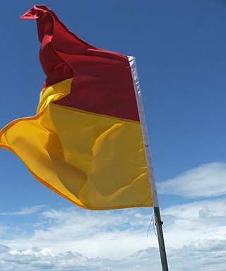
Surf lifesaving is a multifaceted social movement that comprises key aspects of voluntary lifeguard services and competitive surf sport. Originating in early 20th century Australia, the movement has expanded globally to other countries, including New Zealand, Ireland, South Africa, and the United Kingdom. Surf lifesavers in Australia are colloquially known as "Clubbies".

<span class="mw-page-title-main">Miramar Peninsula</span> Land in Wellington city, New Zealand

Te Motu Kairangi / Miramar Peninsula is a large peninsula on the southeastern side of the city of Wellington, New Zealand. It is located at the entrance to Wellington Harbour, in Wellington's eastern suburbs. According to Māori legend, it was formed when the taniwha Whaitaitai beached as he tried to escape the confines of the harbour. It contains the suburb of Miramar.

<span class="mw-page-title-main">Onehunga</span> Suburb in Auckland, New Zealand

Onehunga is a suburb of Auckland in New Zealand and the location of the Port of Onehunga, the city's small port on the Manukau Harbour. It is eight kilometres south of the city centre, close to the volcanic cone of Maungakiekie / One Tree Hill.

<span class="mw-page-title-main">Hataitai</span> Suburb of Wellington City, New Zealand

Hataitai is an inner-city suburb of Wellington, the capital of New Zealand, 3.5 kilometres southeast of the city centre. The suburb extends over the southeastern flank of Mount Victoria and down a valley between the Town Belt and a ridge along the shoreline of Evans Bay. Hataitai is bounded by Hepara Street, Grafton Road and the suburb of Roseneath in the north, Wellington Harbour in the east, Cobham Drive, Wellington Road and Crawford Road in the south, and Alexandra Road in the west.

<span class="mw-page-title-main">Oriental Bay</span> Suburb of Wellington City, New Zealand

Oriental Bay is a bay and suburb of Wellington, the capital city of New Zealand. Noted for being both a popular beach and a luxurious centre of affluence in the city, it is located close to the Central Business District on Wellington Harbour.

<span class="mw-page-title-main">Wellington Airport</span> Airport in Wellington, New Zealand

Wellington International Airport is an international airport located in the suburb of Rongotai in Wellington. It lies 3 NM or 5.5 km south-east from the city centre. It is a hub for Air New Zealand and Sounds Air. Wellington International Airport Limited, a joint venture between Infratil and the Wellington City Council, operates the airport. Wellington is the third busiest airport in New Zealand after Auckland and Christchurch, handling a total of 3,455,858 passengers in the year ending June 2022, and the third busiest in terms of aircraft movements. The airport, in addition to linking many New Zealand destinations with national and regional carriers, also has links to major cities in eastern Australia. It is the home of some smaller general aviation businesses, including the Wellington Aero Club, which operates from the general aviation area on the western side of the runway.

<span class="mw-page-title-main">Main Beach, Queensland</span> Suburb of Gold Coast, Queensland, Australia

Main Beach is a coastal town and suburb in the City of Gold Coast, Queensland, Australia. In the 2016 census, the suburb of Main Beach had a population of 3,883 people.

<span class="mw-page-title-main">Brighton, South Australia</span> Suburb of Adelaide, South Australia

Brighton is a coastal suburb of Adelaide, South Australia, situated between Seacliff and Glenelg and aside Holdfast Bay. Some notable features of the area are the Brighton-Seacliff Yacht Club, the Brighton Surf Lifesaving Club, the Brighton Jetty, and a beach. The Windsor Theatre, constructed in 1925, is a long-standing institution.

<span class="mw-page-title-main">Surf Life Saving New Zealand</span>

Surf Life Saving New Zealand (SLSNZ) is the national association representing 74 Surf Life Saving Clubs in New Zealand. The organisation's motto is 'In it for Life'. This refers to both the long relationship many members have with the organisation, as well as to the organisation's purpose of preventing drowning and injury, thereby saving lives.

<span class="mw-page-title-main">Te Aro</span> Suburb of Wellington City, New Zealand

Te Aro is an inner-city suburb of Wellington, New Zealand. It comprises the southern part of the central business district including the majority of the city's entertainment district and covers the mostly flat area of city between The Terrace and Cambridge Terrace at the base of Mount Victoria.

<span class="mw-page-title-main">Rongotai</span> Suburb of Wellington City, New Zealand

Rongotai is a suburb of Wellington, New Zealand, located southeast of the city centre. It is on the Rongotai isthmus, between the Miramar Peninsula and the suburbs of Kilbirnie and Lyall Bay. It is known mostly for being the location of the Wellington International Airport. It is roughly in the centre of the Rongotai electorate, which is much bigger than the suburb.

<span class="mw-page-title-main">Rongotai (New Zealand electorate)</span> Electoral district in Wellington, New Zealand

Rongotai is a New Zealand electorate, returning a single member to the New Zealand House of Representatives. The current MP for Rongotai is Julie Anne Genter of the Green Party. She has held this position since the 2023 general election.

<span class="mw-page-title-main">Kilbirnie, New Zealand</span> Suburb of Wellington City, New Zealand

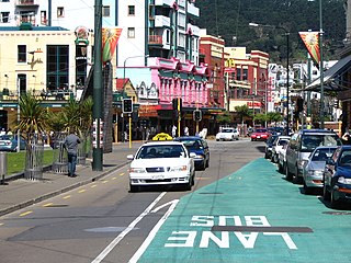
Kilbirnie is a suburb of Wellington in New Zealand, 3 kilometres (1.9 mi) to the south-east of the city centre. Travellers can reach Kilbirnie from the Wellington central business district via the Mount Victoria Tunnel and Hataitai, or over Mount Victoria, or around the coast.

<span class="mw-page-title-main">Rongotai College</span> School

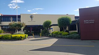
Rongotai College is a state single-sex boys' secondary school in the southeastern suburb of Rongotai, Wellington, New Zealand. Serving Years 9 to 13, the school has 622 students as of July 2015.

<span class="mw-page-title-main">Star Boating Club</span> Rowing club in Wellington, New Zealand

Star Boating Club is a Wellington based rowing club, situated on the waterfront adjacent to Whairepo Lagoon. It is the oldest rowing club in Wellington, having existed since 1866. Star is one of New Zealand's oldest active rowing clubs and sporting organisations. It is home to rowers of all ages.

<span class="mw-page-title-main">Westshore, New Zealand</span> Suburb of Napier, New Zealand

Westshore is a northern coastal suburb of the city of Napier in Hawke's Bay, New Zealand.

<span class="mw-page-title-main">Evans Bay</span> Bay in Wellington, New Zealand

Evans Bay is a large bay at the southern end of Wellington Harbour, New Zealand. Located between the Miramar Peninsula and Hataitai, it was the site of New Zealand's first patent slip and served as Wellington's international flying-boat terminal from 1938 until 1956. It is named after George Samuel Evans, an early Wellington settler.

<span class="mw-page-title-main">Roseneath, Wellington</span> Suburb of Wellington City, New Zealand

Roseneath is a suburb of Wellington, New Zealand, located east of Oriental Bay and north of Hataitai. The peninsula was named after Rosneath, a village on the Rosneath Peninsula on Scotland's River Clyde, and has no association with roses.

Omanu is a beach and suburb in Mount Maunganui, Tauranga, in the Bay of Plenty Region of New Zealand's North Island.

<span class="mw-page-title-main">Moa Point</span> Suburb in Wellington City, New Zealand

Moa Point is a small suburb in Wellington, New Zealand, situated on the south coast between Lyall Bay to the west and Tarakena Bay to the east. As of 2015 there were 21 households in the suburb.

References

  1. 1 2 3 Reed, A. W. (2010). Peter Dowling (ed.). Place Names of New Zealand. Rosedale, North Shore: Raupo. ISBN   9780143204107.
  2. 1 2 "ArcGIS Web Application". statsnz.maps.arcgis.com. Retrieved 1 July 2021.
  3. 1 2 "Population estimate tables - NZ.Stat". Statistics New Zealand . Retrieved 25 October 2023.
  4. "Lyall Bay". Land, Air, Water Aotearoa (LAWA). Retrieved 28 October 2022.
  5. Graeme R. Stevens, 1974, Rugged Landscape The Geology of Central New Zealand, A H and A W Reed Ltd.
  6. Gardner, J. & Bell, J. [Eds.] 2008. The Taputeranga Marine Reserve, Wellington, NZ., 532 pp.
  7. Downes, G; Grapes, R (1999). The 1855 Wairarapa, New Zealand, earthquake - historical data (PDF). Lower Hutt, New Zealand: Institute of Geological and Nuclear Sciences. ISBN   0-478-09669-0.
  8. "Chart of Port Nicholson". New Zealand Gazette and Wellington Spectator. 12 September 1840. Retrieved 3 June 2021 via Paperspast.
  9. Best, Elsdon (1919). The Land of Tara and they who settled it. New Plymouth, New Zealand: The Polynesian Society. Hua-te-taka. The eastern headland of Lyall Bay. Crawford's map gives Hue-te-para as the name of the sandy beach at Lyall Bay, but none of the natives consulted by the writer knew the name.
  10. Hooker, J. D. (11 March 1996). "David Lyall (1817-1895)". Botanical Electronic News (Reproduction of obituary in J. Bot. 33: 209-211. 1895). Retrieved 3 June 2021.
  11. "The empire city: street and harbour nomenclature". Wairarapa Daily Times. 5 August 1908. Retrieved 10 November 2022 via Paperspast.
  12. Hayward, H. M. (9 April 1910). "Lyell or Lyall?". Evening Post. Retrieved 10 November 2022 via Paperspast.
  13. "[untitled]". Evening Post. 3 October 1896. Retrieved 3 June 2021 via Paperspast.
  14. "Maranui School committee". Evening Post. 5 February 1909 via Paperspast.
  15. "A breezy trip". Paperspast. 1 June 1909. Retrieved 27 October 2022.
  16. "By tram to Lyall Bay". Evening Post. 16 December 1909. Retrieved 28 October 2022.
  17. "On the isthmus: Lyall Bay and Kilbirnie". Evening Post. 15 September 1910. Retrieved 28 October 2022 via Paperspast.
  18. "Roads & recreation". Evening Post. 24 June 1925. Retrieved 28 October 2022 via Paperspast.
  19. "Lyall Bay". Evening Post. 18 August 1927. Retrieved 28 October 2022 via Paperspast.
  20. "Lyall Bay Sea Wall". www.wellingtoncityheritage.org.nz. Retrieved 27 October 2022.
  21. "[Advertisement]". Evening Post. 16 March 1943. Retrieved 30 October 2022 via Paperspast.
  22. "Sand problem". Evening Post. 4 April 1946.
  23. "Sand removal at Lyall Bay: Fine beach is being ruined". Evening Post. 26 January 1961.
  24. "'Dumping is futile endeavour': Lyall Bay ruined by junk swept up by the current". Evening Post. 27 January 1961.
  25. "Promised seawall needed: Southerly swept sand on unprotected houses in bay". Evening Post. 3 June 1965.
  26. "Will present erosion". Evening Post. 4 October 1975.
  27. Milne, Randall; Sawyer, John (2002). Coastal foredune vegetation in Wellington Conservancy (PDF). Wellington, New Zealand: Department of Conservation. p. 16. ISBN   0-478-22337-4.
  28. "Proposed development of Rongotai Aerodrome". Poverty Bay Herald. 7 December 1935. Retrieved 2 November 2022 via Paperspast.
  29. "Airport scheme". Evening Post. 14 January 1936. Retrieved 2 November 2022 via Paperspast.
  30. "Wellington Airport : official souvenir brochure". Wellington City Libraries. Retrieved 2 November 2022.
  31. "[untitled plan of proposed works]". Evening Post. 22 July 1944. Retrieved 2 November 2022 via Paperspast.
  32. "Rongotai Airport plans". Evening Post. 8 July 1944. Retrieved 2 November 2022 via Paperspast.
  33. "Rongotai Airport". Otago Daily Times. 18 October 1950. Retrieved 2 November 2022 via Paperspast.
  34. "Reconstruction of airport". Press. 29 January 1954. Retrieved 2 November 2022 via Paperspast.
  35. "Modern facilities at new airport". Press. 27 April 1959. Retrieved 2 November 2022 via Paperspast.
  36. "Shooting the breakers". Dominion. 7 February 1916 via Paperspast.
  37. "Surf shooting". New Zealand Times. 8 March 1915 via Paperspast.
  38. "Lyall Bay". Surf Break Research. Retrieved 28 October 2022.
  39. "Lyall Bay restoration 'dune' the right thing". Wellington City Council. 22 August 2018. Retrieved 28 October 2022.
  40. "Capital city surfers seek certainty". RNZ. 29 December 2015. Retrieved 28 October 2022.
  41. 1 2 "Surf Lifesaving NZ - Lyall Bay Surf Life Saving Club Celebrates Opening of New Clubhouse". www.surflifesaving.org.nz. Retrieved 29 October 2022.
  42. 1 2 "Maranui Surf Club". wellingtoncityheritage.org.nz. May 2013. Retrieved 29 October 2022.
  43. Sharpe, Marty (15 August 2021). "Lyall Bay Surf Life Saving Club's new clubhouse opens". Stuff. Retrieved 29 October 2022.
  44. Newton, Katherine (5 August 2009). "Historic club, cafe destroyed". Stuff. Retrieved 29 October 2022.
  45. "Lyall Bay Surf Life Saving Club - Lifeguarding and Surf Sport". Lyall Bay SLSC. Retrieved 29 October 2022.
  46. "Surf Lifesaving NZ - Maranui SLSC". www.surflifesaving.org.nz. Retrieved 29 October 2022.
  47. 1 2 "Statistical area 1 dataset for 2018 Census". Statistics New Zealand. March 2020. Lyall Bay (254300). 2018 Census place summary: Lyall Bay
  48. "Lyall Bay School Official School Website". lyallbay.school.nz.
  49. "Lyall Bay School Education Review Office Report". ero.govt.nz. Education Review Office.
  50. "Lyall Bay School Ministry of Education School Profile". educationcounts.govt.nz. Ministry of Education.