
Wellington City Council is a territorial authority in New Zealand, governing the city of Wellington, the country's capital city and third-largest city by population, behind Auckland and Christchurch. It consists of the central historic town and certain additional areas within the Wellington metropolitan area, extending as far north as Linden and covering rural areas such as Mākara and Ohariu. The city adjoins Porirua in the north and Hutt City in the north-east. It is one of nine territorial authorities in the Wellington Region.

Carterton is a small town in the Wellington Region of New Zealand and the seat of the Carterton District. It lies in a farming area of the Wairarapa in New Zealand's North Island. It is located 14 km (8.7 mi) southwest of Masterton and 80 km (50 mi) northeast of Wellington. The town has a population of 5,960, out of a total district population of 10,250.

The Awatere River is a large river flowing through Marlborough, New Zealand. Flowing along the trace of the active Awatere Fault, it runs northeast through a straight valley to the west of the Inland Kaikōura mountains. This valley is parallel with that of the Waiau Toa / Clarence River, 20 kilometres (12 mi) to the south.

Johnsonville is a large suburb in northern Wellington, New Zealand. It is seven kilometres north of the city centre, at the top of the Ngauranga Gorge, on the main route to Porirua. It is commonly known by locals as "J'ville". Johnsonville was settled from the 1840s, became a town by 1896 and grew rapidly during the twentieth century. Johnsonville became an independent borough in 1908 and amalgamated with Wellington City in 1953.

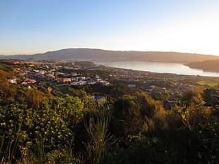
Newlands is one of the northern suburbs of Wellington, New Zealand. It lies approximately 8.1 km north of the city centre and to the east of its nearest neighbour Johnsonville. It has a long history of early settlement and originally was farmed including being the early source of Wellington's milk. Newlands is located in a valley and covers two ridgelines, the side of one of which overlooks Wellington Harbour and up to the Hutt Valley.
Papakōwhai is a suburb of Porirua City. It lies approximately 22 kilometres (14 mi) north of Wellington in New Zealand.

Mount Cook is an inner city suburb of New Zealand's capital city of Wellington, The North Island, New Zealand, 1.74km dead south of Wellington's Central Business District. Its local constituency area is the Wellington Central, and is part of the City of Wellington local government area. The suburb stands on the southern fringe of the central city alongside Te Aro and to the north of Newtown.

Churton Park is a suburb 1.5 km north of Johnsonville in Wellington, the capital city of New Zealand. It was established in the 1970s.
Rahotu is a community in the west of Taranaki, in the North Island of New Zealand. It is located on State Highway 45, 16 kilometres north of Ōpunake and 11 km south of Warea.

Sawyers Bay is a suburb of the New Zealand city of Dunedin. It is located 1.5 kilometres (0.93 mi) to the southwest of Port Chalmers in a wide valley on the shore of Mussel Bay, 13 kilometres (8.1 mi) to the northeast of Dunedin city centre.
Maungaraki is a suburb of Lower Hutt. It is one of several Lower Hutt suburbs on the western hills of the Hutt Valley. It contains the largest suburban development on the Hutt Valley's western escarpment that runs along the Wellington Fault.

Ōwhiro Bay is a southern suburb of Wellington, New Zealand, that overlooks Cook Strait. It is situated west of the larger suburb of Island Bay. The official name of the suburb was changed from Owhiro Bay to Ōwhiro Bay by the New Zealand Geographic Board on 21 June 2019. The Bay and stream are named after the navigator Whiro, who landed the waka Nukutere there, and has been historically settled by the Kati Mamoe, Ngati Ira and Ngai Tara tribes.

Grenada North is a small suburb in northern Wellington, New Zealand. It is 5 km south of Porirua's city centre, and 13 km north of Wellington's city centre. Its western boundary is formed by State Highway 1 and Takapu Road. The suburb itself was named after Grenada in the Caribbean, and most streets are named after Caribbean islands.
Ohariu is a suburb of Wellington, New Zealand. It is a rural area, located 5 kilometres (3.1 mi) from Khandallah.
Paparangi, one of the northern suburbs of Wellington in New Zealand, lies approximately 10 km north of the city centre, north-east of Johnsonville, north-west of Newlands and south of Grenada and Woodridge. The population was 2,841 at the time of the 2013 census, an increase of 96 from the 2006 census population.
Grenada Village is one of the northern suburbs of Wellington, New Zealand, between Paparangi and Grenada North.
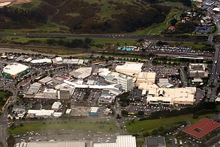
Porirua Central is the central business district and central suburb of Porirua, in the Wellington region of New Zealand's North Island.

The Belmont Viaduct was a railway viaduct in Paparangi, New Zealand. The viaduct was originally built by the Wellington and Manawatu Railway Company as part of the Wellington-Manawatu line. When opened in 1885, with its original kauri wood structure, it was the largest of its kind in New Zealand. At the time it was reputed to be the largest wooden viaduct in the world, however this claim was largely disputed.

Waitohu is a settlement in the Kāpiti Coast District of the Wellington Region of New Zealand's North Island. It is located east of Ōtaki, separated by the North Island Main Trunk railway line. Waitohu Valley Road runs southeast from State Highway 1 along the Waitohu Stream, and then leaves the stream and turns northeast.
Homebush is a rural area in the Masterton District and Wellington Region of New Zealand's North Island. It is about 3 km southeast of Masterton.

