Brooklyn, Wellington

Last updated

Brooklyn
BrooklynWindTurbine.jpg
Brooklyn, Wellington
Coordinates: 41°18′22″S174°45′47″E / 41.30611°S 174.76306°E / -41.30611; 174.76306
CountryNew Zealand
City Wellington City
Local authority Wellington City Council
Electoral ward
  • Paekawakawa/Southern Ward
  • Te Whanganui-a-Tara Māori Ward
Established1888
Area
[1]
  Land398 ha (983 acres)
Population
 (June 2023) [2]
  Total6,920
Postcode(s)
6021
Aro Valley Mount Cook
Karori
Pfeil oben.svg
Pfeil links.svgBrooklynPfeil rechts.svg
Pfeil unten.svg
Vogeltown
Ōwhiro Bay Mornington, Kingston

Brooklyn is a suburb of Wellington, the capital city of New Zealand, under the governance of Wellington City Council. It lies 3 km south of Wellington's central business district on the eastern slopes of the hills above Happy Valley. [3] It is located to the south of Aro Valley and Highbury, west of Mount Cook, north of Vogeltown, Mornington and Ōwhiro Bay and east of Kowhai Park, Panorama Heights, Mitcheltown and Karori.

Contents

It was named after the district of Brooklyn, New York which in turn was named after the village of Breukelen, Utrecht, the Netherlands. [4]

History

Māori history

In pre-European times, Māori knew the Brooklyn hills as Turanga-rere, translated as "the waving plumes of the war-party". [5] The historian James Cowan, in investigating the original Māori names for places in and around Wellington City, suggested this referred to how the tall trees moved in the wind, as "when the warriors stood up to dance... all their feather hair-adornments would wave to and fro". [6] [7]

The small Te Atiawa village of Moera, or Moe-i-te-Ra ("Sleeping in the sun") was sited in the area now covered by Maarama Crescent. [8] (The name was later transferred to the suburb of Moera in Lower Hutt.) The Omaroro kūmara gardens were situated where Connaught Terrace is today. [9] [10] [11] [5]

Brooklyn and the wider Wellington region then and now hosted a number of iwi , or tribes, all represented through a Charter of Understanding with Wellington Regional Council signed in July 2000 (and replacing the original Charter of Understanding of 1993): [12]

In 2013, a Memorandum of Partnership was agreed between the tangata whenua of Te Upoko o te Ika a Maui, or tangata whenua of the region, and the Wellington Regional Council. This built on and replaced the Charter of Understanding. [13] [14]

European settlement

European settlement began in the area during the 1840s. In January 1842 the New Zealand Company ship London commanded by Captain Attwood set sail for its second voyage to Wellington from Gravesend in Kent. It carried 700 tons of cargo, 137 adults and 39 children. On 1 May 1842 the ship arrived in Wellington, with John and Louisa Fitchett and their seven children amongst the passengers. [15]

The New Zealand Company divided the new settlement into 100-acre blocks. The district of Ohiro developed in the early 1840s from three of these blocks (Ohiro Sections 11,12 and 13) on the land surrounding Port Nicholson (officially renamed Wellington Harbour in 1980). [5] Settlers could access the new district only via the steep Ohiro Road from present-day Aro Street. In 1847, John Fitchett [16] [17] purchased Section 11 and established a dairy farm called Ohiro Farm, known also as Fitchett's Farm. [5] [18] [19] A township named Fitchett Town formed in the 1860s; [20] it gained its new name "Brooklyn" in 1888 when the then land-owners, Ashton B. Fitchett (son of John Fitchett d.1875) and R.B. Todman, offered the main subdivision for sale. The offer included 208 lots of Fitchett's Farm next to Brooklyn.

In 1899, after the sale, a further subdivision took place, and the main roads of Mitchell and Todman Streets took form. These were then intersected with Reuben, Bruce, Laura and Charlotte Avenues, Tanera Crescent, Apuka Street and Sugar Loaf Road (the site of the War Memorial). In 1902 Brooklyn was extended further up the Brooklyn Hills when Ashton B. Fitchett sold additional lots of land. Both Karepa and Apuka Streets were extended onto this newly available land. Brooklyn was connected with the city water supply on 24 October 1907, with the pumping station situated on Epuni Street. [21]

A new tramway route opened in May 1906. [22] [23] Unlike the existing route to Brooklyn via Aro Street and Ohiro Road [24] which had excessively steep gradients, the new route was cut through the town belt by Central Park. This route later became today's Brooklyn Road. On 3 May 1907, a tram crashed on the Brooklyn hill due to brake failure and one passenger was killed. [25] [26] [27] [28] The tramway closed in 1957, and the City - Brooklyn route is now served by numbers 7 and 17 buses. The number 7 (City - Brooklyn - Kingston) route was electrified as part of the Wellington City trolley bus service which then was terminated in 2017.

Brooklyn takes its name from the borough in New York City, which in turn recalls the Dutch city Breukelen. [3]

Demographics

Brooklyn, comprising the statistical areas of Brooklyn North, Brooklyn East and Brooklyn South, covers 3.98 km2 (1.54 sq mi). [1] It had an estimated population of 6,920 as of June 2023, with a population density of 1,739 people per km2.

Historical population
YearPop.±% p.a.
20066,123    
20136,507+0.87%
20186,708+0.61%
Source: [29]

Brooklyn had a population of 6,708 at the 2018 New Zealand census, an increase of 201 people (3.1%) since the 2013 census, and an increase of 585 people (9.6%) since the 2006 census. There were 2,544 households, comprising 3,276 males and 3,438 females, giving a sex ratio of 0.95 males per female, with 1,116 people (16.6%) aged under 15 years, 1,722 (25.7%) aged 15 to 29, 3,354 (50.0%) aged 30 to 64, and 525 (7.8%) aged 65 or older.

Ethnicities were 81.3% European/Pākehā, 7.2% Māori, 3.4% Pasifika, 13.9% Asian, and 4.2% other ethnicities. People may identify with more than one ethnicity.

The percentage of people born overseas was 29.7, compared with 27.1% nationally.

Although some people chose not to answer the census's question about religious affiliation, 61.2% had no religion, 24.6% were Christian, 0.4% had Māori religious beliefs, 3.4% were Hindu, 0.9% were Muslim, 1.0% were Buddhist and 3.1% had other religions.

Of those at least 15 years old, 2,916 (52.1%) people had a bachelor's or higher degree, and 270 (4.8%) people had no formal qualifications. 1,938 people (34.7%) earned over $70,000 compared to 17.2% nationally. The employment status of those at least 15 was that 3,483 (62.3%) people were employed full-time, 804 (14.4%) were part-time, and 246 (4.4%) were unemployed. [29]

Individual statistical areas
NameArea
(km2)
PopulationDensity
(per km2)
HouseholdsMedian ageMedian
income
Brooklyn North1.242,2111,78380135.6 years$48,500 [30]
Brooklyn East0.912,7122,9801,09835.0 years$52,800 [31]
Brooklyn South1.831,78597564533.3 years$46,000 [32]
New Zealand37.4 years$31,800

Politics

Brooklyn is within the Wellington City Council's Paekawakawa/Southern General Ward [33] and is currently represented on the Council by two councillors: Laurie Foon and Nureddin Abdurahman.

Brooklyn was a parliamentary electorate from 1946 to 1954. [34] For general elections today, most of Brooklyn is located within the Wellington Central general and Te Tai Tonga Māori parliamentary electorates. Since the 2008 New Zealand general election, the Wellington Central electorate has been represented by Grant Robertson, while Rino Tirikatene has been the Member of Parliament for Te Tai Tonga since 2011. [35]

Landmarks and features

Parks and Town Belt

Brooklyn Hill

Brooklyn Hill is 299 metres (981 ft) high.

Hawkins Hill

Hawkins Hill is 495 metres (1,624 ft) high. It is the highest point on Wellington's southern hills and the site of a white radar dome that can be seen from many parts of the city. [42] [43]

Wind turbine

The original Brooklyn wind-turbine, with Matiu/Somes Island, Mount Victoria and the Miramar Peninsula in the background Brooklyn wind turbine.jpg
The original Brooklyn wind-turbine, with Matiu/Somes Island, Mount Victoria and the Miramar Peninsula in the background

The Electricity Corporation of New Zealand installed the Brooklyn wind turbine on Polhill above north-western Brooklyn in March 1993 as part of a research project into wind-power generation. The Corporation chose the Brooklyn site due to Wellington's "higher than normal" wind patterns and to gain maximum exposure in the viewshed of Wellingtonians. The turbine, visible from many parts of the city, stands 299 metres above sea level. It became the oldest operating wind turbine in New Zealand [44]

The original turbine was decommissioned in 2015 due to age, and replaced in 2016 with a larger version. The original turbine, a Vestas Wind Systems A/S turbine, was a relatively small machine compared with other turbines now installed in New Zealand, such as those at Te Āpiti Wind Farm, with an installed capacity of 225 kW. The present turbine, a German Enercon E-44, has a capacity of 900 kW, enough to power around 490 homes, [45] with the power generated going into the local network for general distribution. The tower hub is 44m high and the blades are 20.8m long.

Meridian Energy has managed the turbine since its formation as a company in 1999 with the deregulation of the New Zealand electricity market.

War memorial

The Brooklyn War Memorial Brooklyn War Memorial.jpg
The Brooklyn War Memorial

Brooklyn's World War I war memorial overlooks northern Brooklyn from the top of Sugarloaf Hill. It lists the names of the 48 Brooklyn soldiers who died in that war. [46] [47] [48]

Soon after the war ended in 1918 a movement to build a memorial began, with the funds raised in two years. The Brooklyn Returned Services Association (RSA) chose as a monument a carved marble statue depicting a soldier with hat in hand, looking towards the harbour heads through which sailed the troopships bearing those who would not return. The foundation stone was laid on 25 April 1922 by Colonel George Mitchell D.S.O. MP, [49] and the memorial was unveiled by Governor-General Viscount Jellicoe on 23 September 1923. [50]

For around 16 years, a board of trustees maintained the memorial, before passing it over to Wellington City Council. In 2003 a nine-month restoration took place, which involved re-securing the structure to the concrete pads that it stands on as well as cleaning, restoring plasterwork, removal of rust and replacing parts that had gone missing.

The inscription on the pedestal reads:

The motherland called and they went and these men died for their country.

Polhill gun emplacements

The well-preserved Polhill anti-aircraft gun emplacements date from March 1942: built for the capital's defence in response to fears of Japanese air-raids or invasion. [17] Once completed the battery had accommodation for 109 army personnel.

The battery stands slightly north of the wind turbine within Panorama Heights subdivision, on a site allocated as reserve land. The site backs on to the firebreak running around the Zealandia wildlife sanctuary.

Street names

When a syndicate led by J.F.E. Wright (a Wellington Provincial Councillor between 1861 and 1863, and then for Karori and Mākara between 1873 and 1876) subdivided Brooklyn, it named a number of its streets after former US Presidents: [51] [52]

Street names with connections to the Fitchett family include Bruce Avenue (named after Bruce Fitchett, grandson of John Fitchett), Laura Avenue (after Laura Walters, who married Ashton B.Fitchett) and Helen Street (after Helen Fitchett, daughter of Ashton B.Fitchett). Reuben Avenue was named after Reuben Short, a long-time employee of John Fitchett. Karepa Street, Apuka Street and Tanera Crescent were named after local Māori who were also employed by John Fitchett. Bretby Street was named after John Fitchett's birthplace in Derbyshire. [51]

Notable buildings and sites

Architectural styles

Brooklyn features a number of different styles of buildings, although very few of the older cottage style remain. One of the oldest recorded in the general area stands in Nairn Street in the neighbouring suburb of Mount Cook. It dates from 1858, and hosts The Colonial Cottage Museum. Brooklyn itself contains examples of many building styles including:

Villa (Simple villas)

The Simple Villa, a style of home built from around 1895, often appears in the form of structures larger than the cottages and Victorian style properties built prior to this time. They generally consisted of a hallway with two rooms off each side and an indoor bathroom at the end. Often a "lean-to" attached to the back of the house would allow for a storage area that might include a wash-house. With the design of the property having the chimney within the house (as opposed to attached to an exterior side wall) fireplaces in the sitting room and kitchen could both use the same chimney — a configuration known as "back-to-back". Brooklynites built these homes from timber — with most of the period features (including architraves, skirting-boards, doors and windows) purchasable as standard items from timber merchants. [53] [54]

Buildings of special interest

House prices

Between 2017 and 2021 the median house sale price in Brooklyn increased from $690,000 to $1.1 million. [69] As of 2021, the median rental in Brooklyn is $685. [70]

Facilities and amenities

Cinema

Brooklyn hosts the Penthouse Cinema, located on Ohiro Road just south of Cleveland Street. Constructed for the Ranish family in the art deco style, it opened on 15 June 1939 as the Vogue Theatre. The Ranish family ran the cinema until 1951, when the Vogue Company Limited took over. The Vogue Company turned the cinema into a television studio where TV commercials were shot. The building was renamed the Penthouse Cinema when it was bought by Merv and Carol Kisby in 1975. Since then additional screens have been added, as well as refurbishment of the interior in keeping with its original style. [71]

Library

Brooklyn has a branch library, opened on 16 February 1905 at 22 Harrison Street as the second branch library of the main Central Library. [72] It opened with 350 books and for 9 hours per week; the Librarian lived in a flat at the rear of the building. In 1960 the library moved to the present building on the corner of Harrison and Cleveland Streets. The original entrance was in Harrison Street, but in 1992 this was closed and ramp access provided in Cleveland Street, enabling pushchairs to enter easily. The original building is now the Brooklyn Playcentre. [73]

Fire station

The Brooklyn Fire Station on Cleveland Street was opened by Sir Māui Pōmare on 10 July 1928. [74] This replaced the earlier fire service which operated with a handcart and pump, and later a horse and cart, in a building where the Scout Hall now stands on Harrison Street. [60]

Sporting facilities

The Wellington Renouf Tennis Centre on Brooklyn Rd, near Central Park, is named after Frank Renouf, a Wellington businessman and keen supporter and follower of tennis.

Playgrounds

Playgrounds include the Central Park play area, [75] the Harrison Street play area [76] and the Mitchell Street play area. [77]

Brooklyn Community Centre

The Brooklyn Community Centre is owned, managed and maintained by the Brooklyn Community Association which marked its 75th anniversary in 2022. [78] [79]

Churches

Malaysian High Commission

The Malaysian High Commission occupies the corner of Washington Avenue and Brooklyn Road.

Transportation

Brooklyn is served by routes 7, 17 and 29 on the Metlink network. On a number of occasions, buses have become stuck on the narrow corners of Brooklyn roads. [86] [87] [88] [89] In 2023, a bus was halted on a narrow street until local residents moved their parked cars. [90]

In 2021, a trial bike/scooter lane was installed on the uphill section of Brooklyn hill from Nairn Street to Ohiro Road. [91]

Education

Brooklyn School

Brooklyn School is a co-educational state school (primary through to intermediate) for Year 1 to 8 students (6 to 12 year olds), [92] with a roll of 412 as of April 2023. [93]

The first school in the area opened in Vogeltown on 3 September 1883. [94] In 1898, the School Board bought some land in Brooklyn between Washington Avenue and Harrison Street and the school building was moved to that site. The school opened in October 1898. [95] [96] [97] The head teacher was Mr John Hopkirk and Miss Jessie Fitchett was the infant mistress. More classrooms were added over the following years. [60] A new Infant Block was opened on 14 August 1930. [98] [99] Miss Jessie Fitchett retired in 1929 and Mr John Hopkirk retired in 1931. [100] [101] [60]

St Bernard's School

St Bernard's School is a co-educational state-integrated Catholic primary school for Year 1 to 8 students, [102] with a roll of 41 as of April 2023. [103]

The school started in 1935 when the Sisters of Mercy provided two sisters, Boniface and Fabian. It opened on 5 February of that year as St Anthony's School Brooklyn, in the church on Jefferson Street - the church itself opened in June 1911. At the time the school opened 44 Catholic children attended the local state school, 43 of whom transferred to St Anthony's on opening day. By the end of the year the roll had risen to 69. [104]

The building remained as one large church hall, installing a temporary partition during the week to create a second classroom. On Fridays after school had finished the partition and desks were removed and replaced with pews for the Mass on Sunday, after which the desks and partition were put back ready for school on Monday morning. [104]

In 1949 the then Parish Priest Father Paul Kane procured land at the present site on Taft Street. The parish re-located the church and had a new school built. However, in 1961 the parish and the school changed their name: the Priest who enacted this bore the name "Bernard". The Sisters of Mercy continued to run the school until 1973 when Doreen Barry became the first lay Principal. [104]

Early childhood education services

Local early childhood education providers include Brooklyn Playcentre, [105] Brooklyn Kindergarten [106] and Brooklyn Kids Early Childhood Education. [107]

Notable people

Related Research Articles

<span class="mw-page-title-main">Wellington</span> Capital city of New Zealand

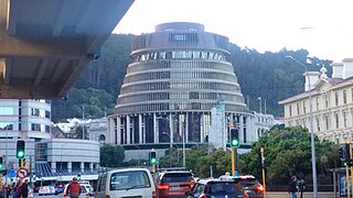
Wellington is the capital city of New Zealand. It is located at the south-western tip of the North Island, between Cook Strait and the Remutaka Range. Wellington is the third-largest city in New Zealand, and is the administrative centre of the Wellington Region. It is the world's southernmost capital of a sovereign state. Wellington features a temperate maritime climate, and is the world's windiest city by average wind speed.

<span class="mw-page-title-main">Nelson, New Zealand</span> City in the South Island, New Zealand

Nelson is a New Zealand city on the eastern shores of Tasman Bay at the top of the South Island. It is the oldest city in the South Island and the second-oldest settled city in New Zealand; it was established in 1841 and became a city by royal charter in 1858.

<span class="mw-page-title-main">Palmerston North</span> City in North Island, New Zealand

Palmerston North is a city in the North Island of New Zealand and the seat of the Manawatū-Whanganui region. Located in the eastern Manawatu Plains, the city is near the north bank of the Manawatu River, 35 km (22 mi) from the river's mouth, and 12 km (7 mi) from the end of the Manawatū Gorge, about 140 km (87 mi) north of the capital, Wellington. Palmerston North is the country's eighth-largest urban area, with an urban population of 82,500. The estimated population of Palmerston North city is 91,800.

<span class="mw-page-title-main">Petone</span> Suburb of Lower Hutt, New Zealand

Petone is a large suburb of Lower Hutt, Wellington. It stands at the southern end of the Hutt Valley, on the northern shore of Wellington Harbour.

<span class="mw-page-title-main">Motueka</span> Town in Tasman District, New Zealand

Motueka is a town in the South Island of New Zealand, close to the mouth of the Motueka River on the western shore of Tasman Bay. It is the second largest in the Tasman Region, with a population of 8,320 as of June 2023.

<span class="mw-page-title-main">Mount Victoria (Wellington suburb)</span> Suburb of Wellington City, New Zealand

Mount Victoria is a suburb of central Wellington, New Zealand, named after the 196 metres (643 ft) hill Mount Victoria to the east. Mount Victoria's residential area is on its north-western slopes.

<span class="mw-page-title-main">Karori</span> Suburb of Wellington City, New Zealand

Karori is a suburb located at the western edge of the urban area of Wellington, New Zealand, 4 km from the city centre and is one of New Zealand's most populous suburbs, with a population of 15,380 in June 2023.

<span class="mw-page-title-main">Miramar, New Zealand</span> Suburb of Wellington City, New Zealand

Miramar is a suburb of Wellington, New Zealand, south-east of the city centre. It is on the Miramar Peninsula, directly east of the isthmus of Rongotai, the site of Wellington International Airport.

<span class="mw-page-title-main">Thorndon, New Zealand</span> Suburb of Wellington City, New Zealand

Thorndon is a historic inner suburb of Wellington, the capital city of New Zealand. Because the suburb is relatively level compared to the hilly terrain elsewhere in Wellington it contained Wellington's elite residential area until its best was destroyed in the 1960s by a new motorway and the erection of tall office buildings on the sites of its Molesworth Street retail and service businesses.

<span class="mw-page-title-main">Oriental Bay</span> Suburb of Wellington City, New Zealand

Oriental Bay is a bay and suburb of Wellington, the capital city of New Zealand. Noted for being both a popular beach and a luxurious centre of affluence in the city, it is located close to the Central Business District on Wellington Harbour.

<span class="mw-page-title-main">Te Aro</span> Suburb of Wellington City, New Zealand

Te Aro is an inner-city suburb of Wellington, New Zealand. It comprises the southern part of the central business district including the majority of the city's entertainment district and covers the mostly flat area of city between The Terrace and Cambridge Terrace at the base of Mount Victoria.

<span class="mw-page-title-main">Hamilton East, New Zealand</span> Suburb of Hamilton, New Zealand

Hamilton East is a suburb in central Hamilton in New Zealand. The suburb's primary commercial and retail precinct is located along Grey Street. Hamilton East is characterised by villas and bungalows built early in the 20th century.

Wellington City Libraries is the public library service for Wellington, New Zealand.

<span class="mw-page-title-main">Lyall Bay</span> Suburb of Wellington City, New Zealand

Lyall Bay is a bay and suburb on the south side of the Rongotai isthmus in Wellington, New Zealand.

<span class="mw-page-title-main">Northland, Wellington</span> Suburb of Wellington City, New Zealand

Northland is a suburb in west-central Wellington, New Zealand. Not far from Victoria University it also includes low-priced accommodation popular with young students. It borders the suburbs of Highbury, Kelburn, Thorndon, Wilton, Wadestown and Karori. Northland is populated by a mix of university students, young professionals and families. Part of the area was known as Creswick until the late 19th century when new roads and building sites were developed by the landowner, C J Pharazyn, who marketed the whole area as Northland. At that time it was described in The Evening Post as "Wellington's best suburb".

<span class="mw-page-title-main">Thomas Turnbull</span> New Zealand architect

Thomas Turnbull (1824–1907) was a notable New Zealand architect.

<span class="mw-page-title-main">Wadestown, New Zealand</span> Suburb of Wellington City, New Zealand

Wadestown is a northern suburb of Wellington, located about 2–3 km by road from the Wellington central business district and the New Zealand Parliament Buildings.

<span class="mw-page-title-main">Evans Bay</span> Bay in Wellington, New Zealand

Evans Bay is a large bay at the southern end of Wellington Harbour, New Zealand. Located between the Miramar Peninsula and Hataitai, it was the site of New Zealand's first patent slip and served as Wellington's international flying-boat terminal from 1938 until 1956. It is named after George Samuel Evans, an early Wellington settler.

<span class="mw-page-title-main">Whitmore Street</span>

Whitmore Street is at the boundary of the central business district and the government buildings area of Wellington, New Zealand's capital. The street runs almost north-south and is one of those linking Lambton Quay, Wellington's main shopping street, with Stout Street, Featherston Street and the harbourside at Customhouse/ Waterloo Quay. It is in the suburb of Pipitea.

References

  1. 1 2 "ArcGIS Web Application". statsnz.maps.arcgis.com. Retrieved 27 June 2021.
  2. "Population estimate tables - NZ.Stat". Statistics New Zealand . Retrieved 25 October 2023.
  3. 1 2 "New Zealand Gazetteer: Brooklyn". Toitū Te Whenua Land Information New Zealand. Retrieved 12 March 2023.
  4. Reed, A. W.; Dowling, Peter (2010). Place names of New Zealand (Revised ed.). Auckland: Penguin. p. 59. ISBN   9780143204107.
  5. 1 2 3 4 Vickers, Joy (1983). Early Brooklyn. Wellington: Millwood Press. p. 7. ISBN   0908582668.
  6. Cowan, James (8 June 1912). "Old Wellington: the original place-names: stories in words,and some geography". Evening Post. p. 10. Retrieved 16 March 2023.
  7. Tohunga (1 October 1934). "The wisdom of the Maori". The New Zealand Railways Magazine. 9 (7): 37.
  8. 1 2 Lawlor, Pat (1959). Old Wellington Days. Wellington: Whitcombe & Tombs Limited. p. 203.
  9. "History of Polhill Reserve". Wellington City Council. Archived from the original on 24 March 2023. Retrieved 24 March 2023.
  10. Raukura Consultants. "Cultural Impact Report: Prince of Wales Park Reservoir" (PDF). Wellington Water. Retrieved 24 March 2023.
  11. Wellington Town Belt Management Plan (PDF). Wellington: Wellington City Council. 2018. p. 242. ISBN   978-0-947521-05-9.
  12. "The Charter of Understanding between Te Tangata Whenua o Te Upoko o te Ika a Maui and Wellington Regional Council" (PDF). Greater Wellington Regional Council. July 2000. Retrieved 18 March 2023.
  13. "Liaising with Māori". Greater Wellington: Te Pane Matua Taiao. 16 August 2021. Retrieved 24 March 2023.
  14. Memorandum of Partnership between Tangata Whenua ki Te Upoko o te Ika a Maui and Wellington Regional Council Te Pane Matua Taiao (PDF). Wellington: Wellington Regional Council. 2013.
  15. Ward, Louis E. (1928). Early Wellington. Auckland: Whitcombe and Tombs Limited. pp. 106–107.
  16. "The Cyclopedia of New Zealand (Wellington Provincial District) Fitchett, John". NZETC New Zealand Electronic Text Centre Te Pūhikotuhi o Aotearoa. Retrieved 12 March 2023.
  17. 1 2 3 4 5 6 7 "Brooklyn local history". Wellington City Libraries Te Matapihi ki te ao nui. Retrieved 12 March 2023.
  18. "Fitchett's Farm: a historic property: the old farmhouse". Evening Post. 13 June 1933. p. 5. Retrieved 24 March 2023.
  19. "Advertisements: genuine milk". Wellington Independent. 16 September 1857. p. 4. Retrieved 24 March 2023.
  20. "Brooklyn". New Zealand History. Retrieved 12 March 2023.
  21. "Turning it on: Brooklyn's water supply". Evening Post. 24 October 1907. p. 8. Retrieved 25 March 2023.
  22. "Brooklyn tramway: permit to run issued". Evening Post. 9 May 1906. p. 8. Retrieved 23 March 2023.
  23. "The Brooklyn tramway". Evening Post. 10 May 1906. p. 4. Retrieved 23 March 2023.
  24. Mitchell, Charlie (18 September 2014). "Ohiro Rd's chequered history". Stuff. Retrieved 24 March 2023.
  25. "Brooklyn tram accident: Shows the aftermath of a tram accident on Brooklyn hill". Wellington City Recollect. Retrieved 12 March 2023.
  26. "A tram accident on Brooklyn Road, Wellington". National Library. Retrieved 12 March 2023.
  27. Fensome, Alex (11 March 2015). "Tram crash proved fatal". Stuff. Retrieved 12 March 2023.
  28. "Brooklyn Tram Accident, Wellington". Museum of New Zealand Te Papa Tongarewa. Retrieved 12 March 2023.
  29. 1 2 "Statistical area 1 dataset for 2018 Census". Statistics New Zealand. March 2020. Brooklyn North (251500), Brooklyn East (251900) and Brooklyn South (252200).
  30. 2018 Census place summary: Brooklyn North
  31. 2018 Census place summary: Brooklyn East
  32. 2018 Census place summary: Brooklyn South
  33. "Ward maps and boundaries". Wellington City Council. 9 December 2022. Retrieved 16 April 2023.
  34. "General election: Mr Fraser's opponent". Otago Daily Times. 6 September 1946. p. 4. Retrieved 16 April 2023.
  35. "Te Tai Tonga Electorate Profile". New Zealand Parliament: Pāremata Aotearoa. 30 September 2012. Retrieved 16 April 2023.
  36. Ross, Kirstie (6 March 2017). "Wellington's Central Park: A ramble through its history". Museum of New Zealand Te Papa Tongarewa. Retrieved 12 March 2023.
  37. "Central Park". Upstream: Friends of Central Park. 12 July 2014. Retrieved 12 March 2023.
  38. Bowman, Alana (2019). "Central Park steps". Wellington Steps. Retrieved 12 March 2023.
  39. Hunt, Tom (27 September 2022). "Wild pigs killing goats, menacing dogs in suburban Wellington". Stuff. Retrieved 16 April 2023.
  40. "Wild pigs spotted throughout suburban Wellington". RNZ. 27 September 2022. Retrieved 16 April 2023.
  41. Hunt, Tom (10 February 2023). "Murderous Wellington pig with taste for baby goats 'a thing of nightmares'". Stuff. Retrieved 16 April 2023.
  42. "Hawkins Hill". Peak bagging. 23 November 2016. Retrieved 21 March 2023.
  43. "Te Kopahou and Brooklyn wind turbine". Wellington City Council. 5 October 2021. Retrieved 21 March 2023.
  44. Brooklyn | New Zealand Wind Energy Association Archived August 7, 2007, at the Wayback Machine
  45. "Brooklyn Wind Turbine". Meridian Energy. Retrieved 17 June 2019.
  46. "Brooklyn Memorial". War Memorials Wellington. 2019.
  47. "Brooklyn war memorial". NZHistory Nga korero a ipurangi o Aotearoa. 28 April 2016. Retrieved 21 March 2023.
  48. "Brooklyn war memorial: Heritage object, Sugarloaf Hill Memorial". Wellington Heritage: Wellington City Council. Retrieved 21 March 2023.
  49. "At Brooklyn: "The Spirit of Anzac"". New Zealand Times. 26 April 1922. p. 10. Retrieved 21 March 2023.
  50. "To Glory of God: Brooklyn's war memorial unveiled by Governor-General". Evening Post. 24 September 1923. p. 6. Retrieved 21 March 2023.
  51. 1 2 Irvine-Smith, F.L. (1948). The streets of my city: Wellington, New Zealand. Wellington: A.H. & A.W. Reed. pp. 236–239. ISBN   0589008897.
  52. "Street Smart: Street name themes by suburb". Wellington City Council: Our Wellington: Tō Tātou Pōneke. 16 December 2021. Retrieved 17 April 2023.
  53. Schrader, Ben (5 September 2013). "Housing: Style and form". Te Ara: the encyclopedia of New Zealand. Retrieved 24 March 2023.
  54. "Renovate: the technical resource for industry". BRANZ. Retrieved 24 March 2023.
  55. "House designed by Ernst Plischke for W B Sutch, Todman Street, Brooklyn, Wellington". DigitalNZ. January 1962. Retrieved 18 March 2023.
  56. Romanos, Joseph (28 August 2013). "Todman St's steep rise to war and spy history". The Wellingtonian. Retrieved 18 March 2023.
  57. "Sutch House (Wellington, N.Z.)". National Library. Retrieved 18 March 2023.
  58. Thematic heritage study of Wellington (PDF). Wellington: Wellington City Council. 2013. p. 31. ISBN   978-1-877232-72-5.
  59. Klein-Nixon, Kylie (17 August 2021). "'Like coming home to a warm hug': The 1914 Brooklyn cottage with a link to Wellington's brick-making past". Stuff. Retrieved 23 March 2023.
  60. 1 2 3 4 Vickers, Joy (1998). Eartly Brooklyn revisited (2nd ed.). Wellington: Northland Print 1998 Limited. ISBN   0473057204.
  61. "Buildings and contracts: tenders accepted". New Zealand Mail. 27 March 1907. p. 57. Retrieved 25 March 2023.
  62. Romanos, Joseph (3 December 2009). "The Wellingtonian interview: Lois Daish". Stuff. Retrieved 25 March 2023.
  63. NZ Guild of Food Writers (25 June 2010). "New Zealand food writers honour Lois Daish". Scoop. Retrieved 25 March 2023.
  64. "Wellington Heritage: Commercial Building: Ferkins' Building". Wellington City Council. 25 July 2017. Retrieved 25 March 2023.
  65. "Brooklyn Post Office". Dominion. 6 June 1912. p. 4. Retrieved 25 March 2023.
  66. "Local and general". Dominion. 16 May 1914. p. 4. Retrieved 25 March 2023.
  67. "Wellington Heritage: Brooklyn Post Office Building (Former), Garage And Sheds". Wellington City Council. 24 November 2016. Retrieved 25 March 2023.
  68. "Central Park Hospital, Ohiro Road, Brooklyn". Wellington City Recollect. Retrieved 16 April 2023.
  69. "Oneroof suburb profile Brooklyn". OneRoof. Retrieved 25 June 2021.
  70. "Oneroof suburb profile Brooklyn". Oneroof. Retrieved 25 June 2021.
  71. "Our story". Penhouse Cinema & Cafe. Retrieved 12 March 2023.
  72. "Brooklyn Public Library: the opening ceremony". Evening Post. 17 February 1905. p. 2. Retrieved 18 March 2023.
  73. "Brooklyn Library (Former): Brooklyn Playcentre". Wellington City Council. 25 July 2017. Retrieved 18 March 2023.
  74. "Early history". Evening Post. 11 July 1928. p. 6. Retrieved 21 March 2023.
  75. "Central Park". Wellington City Council. 21 October 2020. Retrieved 16 April 2023.
  76. "Harrison Street play area renewal". Wellington City Council. 14 February 2022. Retrieved 16 April 2023.
  77. "Locations of playgrounds and play areas in Wellington". Wellington City Council. 5 April 2022. Retrieved 16 April 2023.
  78. "75th anniversary". Brooklyn Community Centre. Retrieved 21 March 2023.
  79. "Community support shines in lockdown". Wellington City Council: Tō Tātou Pōneke: Our Wellington. 11 May 2020. Retrieved 16 April 2023.
  80. Derby, Mark (20 April 2018). "Baptist Sunday-school procession". Te Ara - the Encyclopedia of New Zealand. Retrieved 21 March 2023.
  81. "Brooklyn Baptist Church: opening services". Evening Post. 11 July 1910. p. 3. Retrieved 21 March 2023.
  82. "Brooklyn Baptist Church (Wellington, N.Z.)". National Library. Retrieved 21 March 2023.
  83. Nightingale, Melissa (23 February 2021). "St Matthew's Church in Brooklyn, Wellington could be demolished by new owner". NZ herald. Retrieved 16 April 2023.
  84. Klein-Nixon, Kylie (20 November 2020). "Mid-century, architecturally-designed church ripe for conversion". Stuff. Retrieved 16 April 2023.
  85. Kohout, Jan (13 May 2021). "110-year-old Catholic church closing in Brooklyn". Wellington Scoop. Retrieved 21 March 2023.
  86. McCallum, Hanna (30 March 2023). "How did I get here? The stuck trucks and buses on Wellington's tight roads". Stuff. Retrieved 31 March 2023.
  87. Hunt, Tom (7 September 2016). "Stuck bus a six-monthly affair for bemused Brooklyn, Wellington residents". Stuff. Retrieved 31 March 2023.
  88. "Wrong turn leads to stuck bus in Wellington". Stuff. 9 September 2016. Retrieved 31 March 2023.
  89. Chapman, Katie (4 December 2009). "A funny thing happened on the way up Fortunatus St". Stuff. Retrieved 31 March 2023.
  90. Knell, Conor (13 April 2023). "Wellington bus trapped on narrow street - residents say it's not the first time". Stuff. Retrieved 16 April 2023.
  91. "Transport projects: Brooklyn to city: Southern connection from the Brooklyn shops". Wellington City Council. Retrieved 24 March 2023.
  92. "Brooklyn School Education Review Office Report". ero.govt.nz. Education Review Office.
  93. "Brooklyn School Ministry of Education School Profile". educationcounts.govt.nz. Ministry of Education.
  94. "Advertisements". Evening Post. 1 September 1883. p. 3. Retrieved 23 March 2023.
  95. "Brooklyn School Official School Website". brooklynprimary.school.nz.
  96. The school on the hill: Brooklyn School 1883-1983. Wellington: Brooklyn School Centennial Committee. 1983.
  97. "Advertisements". Evening Post. 3 October 1898. p. 6. Retrieved 23 March 2023.
  98. "Brooklyn School: improvements made". Evening Post. 13 August 1930. p. 13. Retrieved 23 March 2023.
  99. "Brooklyn School: new rooms opened: headmaster honoured". Evening Post. 15 August 1930. p. 15. Retrieved 23 March 2023.
  100. "School committees annual reports: Brooklyn". Evening Post. 26 April 1930. p. 7. Retrieved 23 March 2023.
  101. "Children's farewell: a popular headmaster". Evening Post. 5 December 1931. p. 7. Retrieved 23 March 2023.
  102. "St Bernard's School Education Review Office Report". ero.govt.nz. Education Review Office.
  103. "St Bernard's School Ministry of Education School Profile". educationcounts.govt.nz. Ministry of Education.
  104. 1 2 3 "St Bernard's School Official School Website". stbernards.school.nz.
  105. "Brooklyn Playcentre". Education Review Office. 14 November 2022. Retrieved 16 April 2023.
  106. "Brooklyn Kindergarten". Education Review Office. 17 June 2015. Retrieved 16 April 2023.
  107. "About Us". Brooklyn Kids Early Childhood Centre. Retrieved 16 April 2023.
  108. "Ashton Fitchett" (PDF). New Zealand Medical Journal. 121 (1285): 153–154. 7 November 2008.
  109. Lawlor, Pat (1959). Old Wellington Days. Wellington: Whitcombe & Tombs Limited. pp. 157–158.
  110. Hannah, Kate (2019). "Adams, Nancy Mary". Te Ara: The encyclopedia of New Zealand. Retrieved 24 March 2023.
  111. Duckworth, Marilyn (2000). Camping on the faultline: a memoir. Auckland: Vintage. pp. 246–248. ISBN   1869414136.
  112. "Harris-Ching, Ray". Russell Fink Gallery. Retrieved 15 March 2023.
  113. "Even if he walked with a king, he played bowls with the locals". Stuff. 22 February 2020. Retrieved 24 March 2023.