Houghton Bay

Last updated

Houghton Bay / Valley
HoughtonBayPICT9749.jpg
Houghton Bay
Coordinates: 41°20′31″S174°47′06″E / 41.342°S 174.785°E / -41.342; 174.785
CountryNew Zealand
City Wellington City
Local authority Wellington City Council
Electoral ward
  • Paekawakawa/Southern Ward
  • Te Whanganui-a-Tara Māori Ward
Area
[1]
  Land129 ha (319 acres)
Population
 (June 2022) [2]
  Total1,700
Southgate Melrose Lyall Bay
Island Bay
Pfeil oben.svg
Pfeil links.svgHoughton BayPfeil rechts.svg
Pfeil unten.svg
Cook Strait
South Coast view to South Island SouthCoastPICT1197.JPG
South Coast view to South Island
Houghton Bay Panorama Houghton Bay Panorama.jpg
Houghton Bay Panorama

Houghton Bay, or Houghton Valley, is one of the southern suburbs of Wellington, New Zealand. It is located between Island Bay and Lyall Bay, on the rocky shores of the Cook Strait. It has two beaches, Houghton Bay and Princess Bay, used by surfers, swimmers and divers.

Contents

History

Houghton Bay was named after Captain Robert Houghton, who was the person responsible for the powder magazine on Matiu / Somes Island, and later the signal station at Mount Albert above Houghton Bay. [3]

In the 19th century The Hermit of Island Bay lived in a nearby cave.

Features

Houghton Bay and Valley is predominantly a residential area, but also contains the southern part of Wellington's Southern Walkway, the Buckley Road reserve, Houghton Valley Playcentre, Houghton Valley School and the Southern Headlands Reserve.

Along with other parts of Wellington's South Coast it is a popular recreational diving spot, within the Taputeranga Marine Reserve. In 2005 the decommissioned frigate HMNZS Wellington was sunk off Houghton Bay, and is now an artificial reef and dive location. Houghton Bay is also a surfing spot, like nearby Lyall Bay.

Houghton Valley and Bay are home to musicians and artists, and to the Haewai Meadery and Wind Gardens.

On the hill overlooking the breakers is the Wellington dance and dining venue, The Pines.

The Aurora Australis can be seen, as the light pollution is shielded to some degree by the range of hills along the coastline. A dark sky is necessary as most aurorae are weak and barely visible to the naked eye at this latitude. [4]

Demographics

Houghton Bay statistical area covers 1.29 km2 (0.50 sq mi). [1] It had an estimated population of 1,700 as of June 2022, [2] with a population density of 1,318 people per km2.

Historical population
YearPop.±% p.a.
20061,488    
20131,551+0.59%
20181,677+1.57%
Source: [5]

Houghton Bay had a population of 1,677 at the 2018 New Zealand census, an increase of 126 people (8.1%) since the 2013 census, and an increase of 189 people (12.7%) since the 2006 census. There were 648 households, comprising 810 males and 870 females, giving a sex ratio of 0.93 males per female. The median age was 36.4 years (compared with 37.4 years nationally), with 336 people (20.0%) aged under 15 years, 324 (19.3%) aged 15 to 29, 867 (51.7%) aged 30 to 64, and 153 (9.1%) aged 65 or older.

Ethnicities were 88.2% European/Pākehā, 8.4% Māori, 4.5% Pasifika, 6.6% Asian, and 3.8% other ethnicities. People may identify with more than one ethnicity.

The percentage of people born overseas was 30.4, compared with 27.1% nationally.

Although some people chose not to answer the census's question about religious affiliation, 64.4% had no religion, 23.8% were Christian, 1.3% were Hindu, 0.7% were Muslim, 0.9% were Buddhist and 3.4% had other religions.

Of those at least 15 years old, 618 (46.1%) people had a bachelor's or higher degree, and 96 (7.2%) people had no formal qualifications. The median income was $46,600, compared with $31,800 nationally. 414 people (30.9%) earned over $70,000 compared to 17.2% nationally. The employment status of those at least 15 was that 822 (61.3%) people were employed full-time, 198 (14.8%) were part-time, and 60 (4.5%) were unemployed. [5]

Education

Houghton Valley School is a co-educational state primary school for Year 1 to 6 students, [6] [7] with a roll of 170 as of April 2023. [8] The school was founded in 1930. [9]

See also

Houghton Bay East and Princess Bay PrincessBayPICT9748.jpg
Houghton Bay East and Princess Bay

Related Research Articles

<span class="mw-page-title-main">Eastbourne, New Zealand</span> Suburb of Lower Hutt, New Zealand

Eastbourne is a suburb of Lower Hutt, a part of Wellington, New Zealand. Lying beside the sea, it is a popular local tourist destination via car from Petone or from ferry crossings from central Wellington. An outer suburb, it lies on the eastern shore of Wellington Harbour, five kilometres south of the main Lower Hutt urban area and directly across the harbour from the Miramar Peninsula in Wellington city. A narrow exposed coastal road connects it with the rest of Lower Hutt via the Eastern Bays and the industrial suburb of Seaview. It is named for Eastbourne in England, another seaside town known as a destination for day-trips.
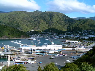
<span class="mw-page-title-main">Plimmerton</span> Suburb of Porirua

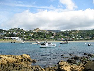
The suburb of Plimmerton lies in the northwest part of the city of Porirua in New Zealand, adjacent to some of the city's more congenial beaches. State Highway 59 and the North Island Main Trunk railway line pass just east of the main shopping and residential area.

<span class="mw-page-title-main">Tokomaru Bay</span> Town in the North Island of New Zealand

Tokomaru Bay is a small beachside community located on the isolated East Coast of New Zealand's North Island. It is 91 km north of Gisborne, on State Highway 35, and close to Mount Hikurangi. The district was originally known as Toka-a-Namu, which refers to the abundance of sandflies. Over the years the name was altered to Tokomaru Bay.

<span class="mw-page-title-main">Mount Victoria (Wellington suburb)</span> Suburb of Wellington City, New Zealand

Mount Victoria is a suburb of central Wellington, New Zealand, named after the 196 metres (643 ft) hill Mount Victoria to the east. Mount Victoria's residential area is on its north-western slopes.

<span class="mw-page-title-main">Silverstream</span> Suburb of Upper Hutt City, New Zealand

Silverstream is a suburb of Upper Hutt in New Zealand, just under 7 km south-west of the Upper Hutt CBD. It is in the lower (southern) part of the North Island of New Zealand at the southern end of Upper Hutt, close to the Taitā Gorge, which separates Upper Hutt from Lower Hutt. The area is sited at the mouth of a small valley formed by the Wellington Region's tectonic activity and, in part, by Hull's Creek, which discharges into the Hutt River.

<span class="mw-page-title-main">Tolaga Bay</span> Town in Gisborne District, New Zealand

Tolaga Bay is both a bay and small town on the East Coast of New Zealand's North Island located 45 kilometres northeast of Gisborne and 30 kilometres south of Tokomaru Bay.

<span class="mw-page-title-main">Island Bay</span> Suburb of Wellington City, New Zealand

Island Bay is a coastal suburb of Wellington, the capital of New Zealand, situated 5 km (3.1 mi) south of the city centre.

<span class="mw-page-title-main">Hataitai</span> Suburb of Wellington City, New Zealand

Hataitai is an inner-city suburb of Wellington, the capital of New Zealand, 3.5 kilometres southeast of the city centre. The suburb extends over the southeastern flank of Mount Victoria and down a valley between the Town Belt and a ridge along the shoreline of Evans Bay. Hataitai is bounded by Hepara Street, Grafton Road and the suburb of Roseneath in the north, Wellington Harbour in the east, Cobham Drive, Wellington Road and Crawford Road in the south, and Alexandra Road in the west.

<span class="mw-page-title-main">Seatoun</span> Suburb of Wellington City, New Zealand

Seatoun, an eastern suburb of Wellington, the capital city of New Zealand, lies on the east coast of the Miramar Peninsula, close to the entrance to Wellington Harbour, some seven kilometres southeast of the CBD. The suburb sits on an exposed promontory close to Barrett Reef, a dangerous area of rocky shallows upon which many ships have foundered, most notably the inter-island ferry TEV Wahine in 1968.

<span class="mw-page-title-main">Pinehaven</span> Suburb of Upper Hutt, New Zealand

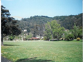
Pinehaven is a suburb of Upper Hutt City in the lower North Island of New Zealand, established in 1927. It is at the southern end of the city, within the pine covered hills east of Silverstream.

<span class="mw-page-title-main">Pāuatahanui</span> Rural locality in Wellington Region, New Zealand

Pāuatahanui is a village in New Zealand's North Island. It is at the far eastern end of what was known as the Pāuatahanui Inlet, an arm of the Porirua Harbour, northeast of Wellington. In local government terms, Pāuatahanui is part of the Northern Ward of Porirua City.

<span class="mw-page-title-main">Te Mārua</span> Suburb of Upper Hutt, New Zealand

Te Mārua is the easternmost urban suburb of Upper Hutt. For reasons of location and distance from the city, the area is often classified as rural. Te Mārua is well known for its Plateau Reserve where remnants of the old Rimutaka Railway path can be found, which now form part of a historic walk. Mt Climie, the highest peak of the Remutaka Range, can also be reached from the reserve. The suburb is also the location of the Wellington Speedway, a nationally important venue for stock car racing, and of the Wellington Naturist Club's club grounds, venue of the historic 2016 World Congress of the International Naturist Federation.

<span class="mw-page-title-main">Lyall Bay</span> Suburb of Wellington City, New Zealand

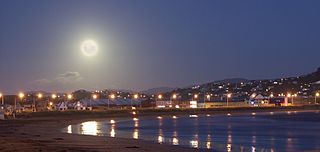
Lyall Bay is a bay and suburb on the south side of the Rongotai isthmus in Wellington, New Zealand.

Heretaunga is a suburb of the city of Upper Hutt, located in the lower (southern) North Island of New Zealand. The settlement, one of the older suburbs in the Hutt Valley, dates from the 1840s when European settlers sought country sections. A prime example of a "leafy" suburb, Heretaunga includes quiet tree-lined streets. It is characterised by large houses, often Edwardian or from the mid-20th century.

<span class="mw-page-title-main">Rongotai</span> Suburb of Wellington City, New Zealand

Rongotai is a suburb of Wellington, New Zealand, located southeast of the city centre. It is on the Rongotai isthmus, between the Miramar Peninsula and the suburbs of Kilbirnie and Lyall Bay. It is known mostly for being the location of the Wellington International Airport. It is roughly in the centre of the Rongotai electorate, which is much bigger than the suburb.

<span class="mw-page-title-main">Kilbirnie, New Zealand</span> Suburb of Wellington City, New Zealand

Kilbirnie is a suburb of Wellington in New Zealand, 3 kilometres (1.9 mi) to the south-east of the city centre. Travellers can reach Kilbirnie from the Wellington central business district via the Mount Victoria Tunnel and Hataitai, or over Mount Victoria, or around the coast.

<span class="mw-page-title-main">Waiwhetū</span> Suburb of Lower Hutt, New Zealand

Waiwhetū is an eastern suburb of Lower Hutt in the Wellington Region situated in the south of the North Island of New Zealand.

<span class="mw-page-title-main">Strathmore Park</span> Suburb of Wellington City, New Zealand

Strathmore Park is a suburb of Wellington City, New Zealand. It is located at the southern end of the Miramar Peninsula to the south of the suburb of Miramar, and due east of the airport. A hill suburb, it overlooks Lyall Bay, Evans Bay and several bays along the Seatoun coast close to the mouth of Wellington Harbour, which lies to the east.

Nelson South is an inner suburb of Nelson, New Zealand. It lies to the southwest of Nelson city centre, between it and Bishopdale, close to the foot of The Grampians. The main inland route to Stoke, New Zealand, Waimea Road, is Nelson South's main road.

<span class="mw-page-title-main">Melrose, New Zealand</span> Suburb of Wellington City, New Zealand

Melrose is a suburb of Wellington, New Zealand. It is south of the city centre, Berhampore and Newtown, and is in the Eastern Ward. Although adjacent to Lyall Bay, it does not have seafront access to the bay.

References

  1. 1 2 "ArcGIS Web Application". statsnz.maps.arcgis.com. Retrieved 2 July 2021.
  2. 1 2 "Population estimate tables - NZ.Stat". Statistics New Zealand . Retrieved 25 October 2022.
  3. Reed, A. W. (2010). Peter Dowling (ed.). Place Names of New Zealand. Rosedale, North Shore: Raupo. p. 173. ISBN   9780143204107.
  4. Aurora Report
  5. 1 2 "Statistical area 1 dataset for 2018 Census". Statistics New Zealand. March 2020. Houghton Bay (254700). 2018 Census place summary: Houghton Bay
  6. "Houghton Valley School Official School Website". houghton.school.nz.
  7. "Houghton Valley School Education Review Office Report". ero.govt.nz. Education Review Office.
  8. "Houghton Valley School Ministry of Education School Profile". educationcounts.govt.nz. Ministry of Education.
  9. Corbishley, G. "Historical Timeline of the Houghton Valley Area" (PDF). Houghton Valley's Web. Retrieved 2 July 2021.