Meredith, Colorado

Last updated

Meredith, Colorado
Meredith, Colorado.JPG
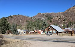
A view of Meredith from across Frying Pan Road
USA Colorado location map.svg
Red pog.svg
Location in Pitkin County and the state of Colorado
Usa edcp location map.svg
Red pog.svg
Meredith, Colorado (the United States)
Coordinates: 39°21′47″N106°43′48″W / 39.36306°N 106.73000°W / 39.36306; -106.73000
Country Flag of the United States (23px).png  United States
State Flag of Colorado.svg  Colorado
County Pitkin
Elevation
[1]
2,369 m (7,773 ft)
Time zone UTC-7 (MST)
  Summer (DST) UTC-6 (MDT)
ZIP code [2]
81642
GNIS feature ID179732 [1]

Meredith is an unincorporated community and a U.S. Post Office in Pitkin County, Colorado, United States. The Meredith Post Office has the ZIP Code 81642. [2]

Contents

Meredith was a limestone quarry town as well as a lumber camp in the 1890s. It is now mainly a "resort area". There are many original occupied buildings.

Climate

Climate data for Meredith, Colorado, 1991–2020 normals: 7825ft (2385m)
MonthJanFebMarAprMayJunJulAugSepOctNovDecYear
Record high °F (°C)58
(14)
59
(15)
65
(18)
75
(24)
89
(32)
91
(33)
98
(37)
93
(34)
90
(32)
80
(27)
68
(20)
59
(15)
98
(37)
Mean maximum °F (°C)48
(9)
50
(10)
56
(13)
66
(19)
76
(24)
85
(29)
89
(32)
87
(31)
83
(28)
73
(23)
60
(16)
50
(10)
92
(33)
Mean daily maximum °F (°C)34.1
(1.2)
35.7
(2.1)
42.9
(6.1)
51.0
(10.6)
62.9
(17.2)
74.5
(23.6)
81.1
(27.3)
79.7
(26.5)
71.2
(21.8)
61.1
(16.2)
44.6
(7.0)
33.7
(0.9)
56.0
(13.4)
Daily mean °F (°C)18.8
(−7.3)
20.7
(−6.3)
28.1
(−2.2)
35.8
(2.1)
45.6
(7.6)
54.3
(12.4)
60.4
(15.8)
59.4
(15.2)
51.6
(10.9)
42.2
(5.7)
28.9
(−1.7)
19.2
(−7.1)
38.7
(3.8)
Mean daily minimum °F (°C)3.5
(−15.8)
5.7
(−14.6)
13.2
(−10.4)
20.6
(−6.3)
28.4
(−2.0)
34.1
(1.2)
39.7
(4.3)
39.1
(3.9)
31.9
(−0.1)
23.3
(−4.8)
13.2
(−10.4)
4.7
(−15.2)
21.5
(−5.8)
Mean minimum °F (°C)−17
(−27)
−16
(−27)
−7
(−22)
7
(−14)
17
(−8)
25
(−4)
31
(−1)
31
(−1)
21
(−6)
11
(−12)
−7
(−22)
−15
(−26)
−22
(−30)
Record low °F (°C)−29
(−34)
−38
(−39)
−30
(−34)
−7
(−22)
6
(−14)
17
(−8)
23
(−5)
23
(−5)
12
(−11)
−5
(−21)
−21
(−29)
−35
(−37)
−38
(−39)
Average precipitation inches (mm)1.50
(38)
1.57
(40)
1.85
(47)
2.15
(55)
1.87
(47)
1.05
(27)
1.70
(43)
1.65
(42)
1.97
(50)
1.71
(43)
1.53
(39)
1.15
(29)
19.7
(500)
Average snowfall inches (cm)19.0
(48)
14.6
(37)
11.6
(29)
7.7
(20)
1.9
(4.8)
0.0
(0.0)
0.0
(0.0)
0.0
(0.0)
0.2
(0.51)
3.4
(8.6)
10.5
(27)
19.1
(49)
88
(223.91)
Source 1: NOAA [3]
Source 2: XMACIS (records & monthly max/mins & Basalt precip/snowfall) [4]

See also

Related Research Articles

<span class="mw-page-title-main">ZIP Code</span> Numeric postal code used in the US and its territories

A ZIP Code is a system of postal codes used by the United States Postal Service (USPS). The term ZIP was chosen to suggest that the mail travels more efficiently and quickly when senders use the code in the postal address.

<span class="mw-page-title-main">Williamsburg, Colorado</span> Town in Fremont County, Colorado, United States

Williamsburg is a statutory town located in Fremont County, Colorado, United States. The town population was 731 at the 2020 census. The Florence post office serves Williamsburg.

<span class="mw-page-title-main">Mount Crested Butte, Colorado</span> Town in Colorado, United States

Mt. Crested Butte is a home rule municipality in Gunnison County, Colorado, United States. Mount Crested Butte is the home of the Crested Butte Mountain Resort. The population was 941 at the 2020 census. ZIP code 81225 serves post office boxes for Mount Crested Butte and for neighboring Crested Butte; mail must be addressed to Crested Butte.

<span class="mw-page-title-main">Lakeside, Colorado</span> Town in Colorado, United States

The Town of Lakeside is a Statutory Town in Jefferson County, Colorado, United States. The town population was 16 at the 2020 United States Census, making Lakeside the least populous municipality in the State of Colorado. Lakeside is immediately west of the City and County of Denver, the most populous municipality in the state. The Denver Post Office serves Lakeside.

<span class="mw-page-title-main">Atwood, Colorado</span> Census Designated Place in Colorado, United States

Atwood is an unincorporated town, a post office, and a census-designated place (CDP) located in and governed by Logan County, Colorado, United States. The CDP is a part of the Sterling, CO Micropolitan Statistical Area. The Atwood post office has the ZIP Code 80722. At the United States Census 2020, the population of the Atwood CDP was 138.

<span class="mw-page-title-main">Paoli, Colorado</span> Town in Phillips County, Colorado, United States

Paoli is a Statutory Town in Phillips County, Colorado, United States. The population was 51 according to the 2020 census.

<span class="mw-page-title-main">Avondale, Colorado</span> Census-designated place in Pueblo County, Colorado, United States

Avondale is a census-designated place (CDP) and post office in and governed by Pueblo County, Colorado, United States. The CDP is a part of the Pueblo, CO Metropolitan Statistical Area. The Avondale post office has the ZIP Code 81022. At the United States Census 2020, the population of the Avondale CDP was 594, while the population of the 81022 ZIP Code Tabulation Area was 1,624 including adjacent areas.

<span class="mw-page-title-main">Hudson, Colorado</span> Town in Colorado, United States

The Town of Hudson is a home rule municipality in Weld County, Colorado, United States. The population was 1,651 at the 2020 census.

<span class="mw-page-title-main">LaSalle, Colorado</span> Town in Colorado, United States

The Town of LaSalle is a Statutory Town in Weld County, Colorado, United States. The town population was 2,359 at the 2020 United States Census.

<span class="mw-page-title-main">Raymer, Colorado</span> Town in Colorado, United States

The Town of Raymer is a Statutory Town located in Weld County, Colorado, United States. The population was 110 at the U.S. Census 2020.

<span class="mw-page-title-main">Wray, Colorado</span> City in Colorado, United States

Wray is the home rule municipality that is the county seat of Yuma County, Colorado, United States. Located in the Colorado Plains, the city is 170 miles east of Denver, 9 miles west of the Nebraska state line, and 25 miles northwest of the Kansas state line. The population was 2,358 at the 2020 United States census.

<span class="mw-page-title-main">Yuma, Colorado</span> City in Colorado, United States

Yuma is a home rule municipality that is the most populous municipality in Yuma County, Colorado, United States. The population was 3,456 at the 2020 census.

Snowmass is an unincorporated community and a U.S. Post Office located in Pitkin County, Colorado, United States. It is situated in the valley of the Roaring Fork River, near the mouth of Snowmass Creek along State Highway 82 between Aspen and Basalt. It consists largely of a post office, several commercial businesses, and surrounding houses and ranches. The Snowmass Post Office has the ZIP Code 81654.

<span class="mw-page-title-main">Mosca, Colorado</span> Unincorporated community in Colorado, United States

Mosca is an unincorporated community and a U.S. Post Office in Alamosa County, Colorado, United States. Mosca's population is 1,072 as of the 2020 census. It was named for the nearby Mosca Pass, which was named for the Spanish explorer, Luis de Moscoso Alvarado. The Mosca Post Office has the ZIP Code 81146. It is best known for its proximity to Great Sand Dunes National Park and Preserve.

<span class="mw-page-title-main">Conejos, Colorado</span> Census Designated Place in Colorado, United States

Conejos is an unincorporated town, a post office, a census-designated place (CDP), and the county seat of Conejos County, Colorado, United States. The Conejos post office has the ZIP Code 81129. At the United States Census 2020, the population of the Conejos CDP was 46. Conejos is the only unincorporated county seat in the State of Colorado.

<span class="mw-page-title-main">Maybell, Colorado</span> Census-designated place in Moffat County, Colorado, United States

Maybell is an unincorporated community and census-designated place (CDP) in and governed by Moffat County, Colorado, United States. The CDP is a part of the Craig, CO Micropolitan Statistical Area.

<span class="mw-page-title-main">Parlin, Colorado</span> Unincorporated community in Colorado, United States

Parlin is an unincorporated community and a U.S. Post Office in Gunnison County, Colorado, United States. The Parlin Post Office has the ZIP Code 81239.

<span class="mw-page-title-main">Yoder, Colorado</span> Unincorporated community in Colorado, United States

Yoder is an unincorporated community and a U.S. Post Office located in El Paso County, Colorado, United States. The Yoder Post Office has the ZIP Code 80864.

Lowry is a neighborhood in the City and County of Denver, Colorado. The Lowry neighborhood is located at the site of the former Lowry Air Force Base. The old Lowry Firehouse has been converted into Colorado Free University. The Denver U.S. Post Office serves the neighborhood. A satellite campus of the University of Northern Colorado also exists in the area.

<span class="mw-page-title-main">Norrie, Colorado</span> Unincorporated community in Pitkin County, Colorado, United States

Norrie is a census-designated place (CDP) located in and governed by Pitkin County, Colorado, United States. The population of the Norrie CDP was 7 at the United States Census 2020. The Meredith post office (Zip Code 81642) serves the area. The CDP is a part of the Glenwood Springs, CO Micropolitan Statistical Area.

References

  1. 1 2 U.S. Geological Survey Geographic Names Information System: Meredith, Colorado
  2. 1 2 "ZIP Code Lookup". United States Postal Service. January 2, 2007. Archived from the original (JavaScript/HTML) on January 1, 2008. Retrieved January 2, 2007.
  3. "Meredith, Colorado 1991-2020 Monthly Normals" . Retrieved November 3, 2023.
  4. "xmACIS". National Oceanic and Atmospheric Administration. Retrieved November 3, 2023.