Redstone, Colorado

Last updated

Redstone, Colorado
Redstone Historic District.JPG
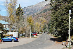
View north up Redstone Boulevard
Etymology: Red sandstone on nearby cliffs
Nickname: 
The Ruby of the Rockies
Pitkin County Colorado Incorporated and Unincorporated areas Redstone Highlighted 0863650.svg
Location of the Redstone CDP in Pitkin County, Colorado
Usa edcp location map.svg
Red pog.svg
Redstone
Location of the Redstone CDP in the United States
Coordinates: 39°11′10″N107°14′45″W / 39.18611°N 107.24583°W / 39.18611; -107.24583 (Redstone CDP, Colorado) [1]
Country Flag of the United States.svg  United States
State Flag of Colorado.svg  Colorado
County Pitkin County
Founded1898
Government
[2]
  Type unincorporated town
Area
[1]
  Total1.134 km2 (0.438 sq mi)
  Land1.134 km2 (0.438 sq mi)
  Water0.000 km2 (0.000 sq mi)
Elevation
[2]
2,187 m (7,176 ft)
Population
 (2020) [3]
  Total127
  Density110/km2 (290/sq mi)
Time zone UTC-7 (MST)
  Summer (DST) UTC-6 (MDT)
ZIP Code [4]
81623
Area code 970
GNIS feature ID 2583286 [2]

Redstone is an unincorporated town and a census-designated place (CDP) located in and governed by Pitkin County, Colorado, United States. The CDP is a part of the Glenwood Springs, CO Micropolitan Statistical Area. The population of the Redstone CDP was 127 at the 2020 United States census. [3] The Carbondale post office (Zip Code 81623) serves Redstone postal addresses. [4]

Contents

The village is listed on the National Register of Historic Places as a historic district and includes several properties that are also separately listed on the National Register. [5] [6] [7]

History

Redstone was established in the late 19th century by industrialist John Cleveland Osgood as part of a coal mining enterprise. Osgood's coal empire also spurred construction of the Crystal River Railroad and Redstone's historic dwellings. As an experiment in "enlightened industrial paternalism," Osgood constructed 84 cottages and a 40-room inn, all with indoor plumbing and electricity, for his coal miners and cokers, as well as modern bathhouse facilities, a club house with a library and a theatre, and a school. Most of these Craftsman-era Swiss-style cottages are still used as homes. [6] [8]

Cleveholm

A dominant feature of Redstone is Cleveholm Manor, commonly called "Redstone Castle," an opulent 42-room Tudor-style mansion that Osgood built for his second wife, Swedish Countess Alma Regina Shelgrem. Construction of Cleveholm Manor, which was designed by New York architects Boal and Harnois, began in 1897 and was completed in 1901. The Castle was part of a 72-acre (29 ha) estate that also included servants' quarters, a gamekeeper's lodge, a carriage house, and a greenhouse. [6] [8] [9] Cleveholm Manor and the gamekeeper's cottage are both independently listed on the National Register as Osgood Castle and Osgood Gamekeeper's Lodge, respectively. As of 2004, the Castle still contained 75 percent of its original furnishings. [7]

The historic inn in Redstone, which is independently listed on the National Register as Redstone Inn, is now operated as a resort inn, offering year-round accommodations. [6]

Geography

The Redstone CDP has an area of 280 acres (1.134 km2), all land. [1]

Climate

Redstone has a humid continental climate (Koppen: Dfb). Summers are warm with cool nights and winters are cold with extremely heavy snowfall averaging 170 inches (430 cm) annually. [10]

Climate data for REDSTONE, COLORADO
MonthJanFebMarAprMayJunJulAugSepOctNovDecYear
Mean daily maximum °F (°C)33.1
(0.6)
36.2
(2.3)
42.7
(5.9)
51.1
(10.6)
60.5
(15.8)
71.8
(22.1)
76.4
(24.7)
74.6
(23.7)
67.0
(19.4)
55.3
(12.9)
39.2
(4.0)
31.5
(−0.3)
53.3
(11.8)
Mean daily minimum °F (°C)7.7
(−13.5)
11.5
(−11.4)
17.3
(−8.2)
24.5
(−4.2)
31.9
(−0.1)
39.4
(4.1)
44.2
(6.8)
43.8
(6.6)
36.7
(2.6)
28.0
(−2.2)
17.5
(−8.1)
9.0
(−12.8)
26.0
(−3.4)
Average precipitation inches (mm)1.78
(45)
2.41
(61)
3.09
(78)
2.04
(52)
2.30
(58)
1.48
(38)
2.23
(57)
1.67
(42)
2.98
(76)
3.02
(77)
2.64
(67)
2.03
(52)
27.67
(703)
Average snowfall inches (cm)26.0
(66)
29.9
(76)
32.4
(82)
12.1
(31)
5.3
(13)
0.5
(1.3)
0
(0)
0
(0)
0.5
(1.3)
6.9
(18)
26.4
(67)
29.5
(75)
170.4
(433)
Source: The Western Regional Climate Center [11]

Demographics

The United States Census Bureau initially defined the Redstone CDP for the 2010 United States census.

Redstone CDP, Colorado
YearPop.±%
2010 130    
2020 127−2.3%
Source: United States Census Bureau

See also

Related Research Articles

<span class="mw-page-title-main">Pitkin County, Colorado</span> County in Colorado, United States

Pitkin County is a county in the U.S. state of Colorado. As of the 2020 census, the population was 17,358. The county seat and largest city is Aspen. The county is named for Colorado Governor Frederick Walker Pitkin.

<span class="mw-page-title-main">Garfield County, Colorado</span> County in Colorado, United States

Garfield County is a county located in the U.S. state of Colorado. As of the 2020 census, the population was 61,685. The county seat is Glenwood Springs. The county is named in honor of United States President James A. Garfield. Garfield County is included in the Glenwood Springs, CO Micropolitan Statistical Area, which is also included in the Edwards-Glenwood Springs, CO Combined Statistical Area.

<span class="mw-page-title-main">Basalt, Colorado</span> Town in Colorado, United States

Basalt is a home rule municipality located in Eagle and Pitkin counties, Colorado, United States. The town population was 3,984 at the 2020 United States Census with 2,917 residing in Eagle County and 1,067 residing in Pitkin County. Basalt is a part of the Edwards-Glenwood Springs, CO Combined Statistical Area.

<span class="mw-page-title-main">Edwards, Colorado</span> Census Designated Place in Colorado, United States

Edwards is an unincorporated town, a post office, and a census-designated place (CDP) located in and governed by Eagle County, Colorado, United States. Edwards is the principal town of the Edwards, CO Micropolitan Statistical Area. The Edwards post office has the ZIP Code 81632. At the United States Census 2020, the population of the Edwards CDP was 11,246. The Edwards Metropolitan District provides services.

<span class="mw-page-title-main">Battlement Mesa, Colorado</span> Ceneus-designated place in Garfield County, Colorado, United States

Battlement Mesa is a census-designated place (CDP) and post office in and governed by Garfield County, Colorado, United States. The CDP is a part of the Glenwood Springs, CO Micropolitan Statistical Area. The Battlement Mesa post office has the ZIP Codes 81635 and 81636. At the United States Census 2020, the population of the Battlement Mesa CDP was 5,438. The Battlement Mesa Metropolitan District provides services.

<span class="mw-page-title-main">Silt, Colorado</span> Town in Colorado, United States

Silt is a statutory town in Garfield County, Colorado, United States. The population was 3,536 at the 2020 census, up from 2,930 at the 2010 census. The town is part of the Glenwood Springs Micropolitan Area.

<span class="mw-page-title-main">Woody Creek, Colorado</span> Census Designated Place in Colorado, United States

Woody Creek is an unincorporated town, a post office, and a census-designated place (CDP) located in and governed by Pitkin County, Colorado, United States. The Woody Creek post office has the ZIP Code 81656. At the United States Census 2020, the population of the Woody Creek CDP was 290. The Woody Creek Metropolitan District provides services. The CDP is a part of the Glenwood Springs, CO Micropolitan Statistical Area.

<span class="mw-page-title-main">Dotsero, Colorado</span> Census Designated Place in Colorado, United States

Dotsero is an unincorporated community and a census-designated place (CDP) located in and governed by Eagle County, Colorado, United States. The CDP is a part of the Edwards, CO Micropolitan Statistical Area. The population of the Dotsero CDP was 1,172 at the United States Census 2020. The Gypsum post office serves the area.

<span class="mw-page-title-main">No Name, Colorado</span> Census-designated place in Garfield County, Colorado, United States

No Name is a census-designated place (CDP) in and governed by Garfield County, Colorado, United States. The CDP is a part of the Glenwood Springs, CO Micropolitan Statistical Area. The population of the No Name CDP was 117 at the United States Census 2020. The Glenwood Springs post office serves the area.

<span class="mw-page-title-main">National Register of Historic Places listings in Pitkin County, Colorado</span> List of National Register of Historic Places in Pitkin County, Colorado, United States

This is a list of the National Register of Historic Places listings in Pitkin County, Colorado.

<span class="mw-page-title-main">Catherine, Colorado</span> Census-designated place in Garfield County, Colorado, United States

Catherine is a census-designated place (CDP) in and governed by Garfield County, Colorado, United States. The CDP is a part of the Glenwood Springs, CO Micropolitan Statistical Area. The population of the Catherine CDP was 235 at the United States Census 2020. The Glenwood Springs post office serves the area.

<span class="mw-page-title-main">Cattle Creek, Colorado</span> Census-designated place in Garfield County, Colorado, United States

Cattle Creek is a census-designated place (CDP) in and governed by Garfield County, Colorado, United States. The CDP is a part of the Glenwood Springs, CO Micropolitan Statistical Area. The population of the Cattle Creek CDP was 662 at the United States Census 2020. The Glenwood Springs post office serves the area.

<span class="mw-page-title-main">Chacra, Colorado</span> Census-designated places in Garfield County, Colorado, United States

Chacra is a census-designated place (CDP) in and governed by Garfield County, Colorado, United States. The CDP is a part of the Glenwood Springs, CO Micropolitan Statistical Area. The population of the Chacra CDP was 331 at the United States Census 2020. The Glenwood Springs post office serves the area.

<span class="mw-page-title-main">Mulford, Colorado</span> Census-designated place in Garfield County, Colorado, United States

Mulford is a Census-designated place (CDP) in and governed by Garfield County, Colorado, United States. The CDP is a part of the Glenwood Springs, CO Micropolitan Statistical Area. The population of the Mulford CDP was 259 at the United States Census 2020. The Carbondale post office serves the area.

<span class="mw-page-title-main">Norrie, Colorado</span> Unincorporated community in Pitkin County, Colorado, United States

Norrie is a census-designated place (CDP) located in and governed by Pitkin County, Colorado, United States. The population of the Norrie CDP was 7 at the United States Census 2020. The Meredith post office (Zip Code 81642) serves the area. The CDP is a part of the Glenwood Springs, CO Micropolitan Statistical Area.

<span class="mw-page-title-main">Redstone Historic District (Colorado)</span> Historic district in Colorado, United States

The Redstone Historic District is located in and near the unincorporated community of that name in western Pitkin County, Colorado, United States. It includes the original community of Redstone as built by Colorado Fuel and Iron (CFI) for the coal miners it employed. In 1989 it was recognized as a historic district and listed on the National Register of Historic Places.

<span class="mw-page-title-main">Redstone Inn</span> United States historic place

The Redstone Inn is located on Redstone Boulevard in Redstone, Colorado, United States. It is a structure in the Tudor Revival architectural styles built at the beginning of the 20th century. In 1980 it was listed on the National Register of Historic Places. It is also a contributing property to the Redstone Historic District listed on the register nine years later.

<span class="mw-page-title-main">John C. Osgood</span>

John Cleveland Osgood was a self-made man who founded the Colorado Fuel and Iron Company and Victor-American Fuel Company but has been referred to as a robber baron. He also created Redstone, Colorado.

<span class="mw-page-title-main">Redstone Castle</span> Historic house in Colorado, United States

Redstone Castle, also known as Cleveholm or Osgood Castle, is a mansion south of Redstone, Colorado, United States. It is a large timber frame structure built in the early 20th century as the home of John C. Osgood, founder of the Colorado Fuel and Iron Company, in a simplified version of the Stick style. In 1971 it was added to the National Register of Historic Places, the first property in Pitkin County to be listed. It was later additionally listed as a contributing property to the Redstone Historic District.

<span class="mw-page-title-main">Osgood Gamekeeper's Lodge</span> Historic house in Colorado, United States

The Osgood Gamekeeper's Lodge is located along State Highway 133 near Redstone, Colorado, United States. It is a timber frame structure built at the beginning of the 20th century. In 1989 it was listed on the National Register of Historic Places.

References

  1. 1 2 3 "State of Colorado Census Designated Places - BAS20 - Data as of January 1, 2020". United States Census Bureau . Retrieved December 26, 2020.
  2. 1 2 3 U.S. Geological Survey Geographic Names Information System: Redstone, Colorado
  3. 1 2 United States Census Bureau. "Redstone CDP, Colorado" . Retrieved April 13, 2023.
  4. 1 2 "Look Up a ZIP Code". United States Postal Service . Retrieved December 26, 2020.
  5. About Redstone, Redstone Community Association website, accessed March 28, 2010
  6. 1 2 3 4 The Historic Redstone Inn website, accessed March 28, 2010
  7. 1 2 Colorado: Transfer of Ownership of Redstone Castle, Redstone, Advisory Council on Historic Preservation, June 1, 2004
  8. 1 2 History of Redstone, Redstone Community Association website, accessed March 28, 2010
  9. Redstone Castle Archived 2010-02-12 at the Wayback Machine , AllAspen.com website, accessed March 28, 2010
  10. "REDSTONE 4 W, COLORADO - Climate Summary". wrcc.dri.edu. Retrieved May 25, 2020.
  11. "REDSTONE 4 W, COLORADO (056970)" . Retrieved December 18, 2015.