Meredith, Colorado

Last updated

Meredith, Colorado
Meredith, Colorado.JPG
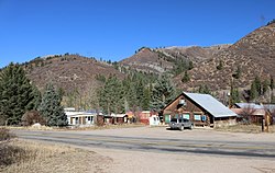
A view of Meredith from across Frying Pan Road
USA Colorado location map.svg
Red pog.svg
Location in Pitkin County and the state of Colorado
Usa edcp location map.svg
Red pog.svg
Meredith, Colorado (the United States)
Coordinates: 39°21′44″N106°43′50″W / 39.36222°N 106.73056°W / 39.36222; -106.73056
Country Flag of the United States.svg  United States
State Flag of Colorado.svg  Colorado
County Pitkin [1]
Elevation
[1]
7,772 ft (2,369 m)
Time zone UTC-7 (MST)
  Summer (DST) UTC-6 (MDT)
ZIP code [2]
81642
GNIS feature ID 0179732

Meredith is an unincorporated community and a U.S. Post Office in Pitkin County, Colorado, United States. The Meredith Post Office has the ZIP Code 81642. [2]

Contents

Meredith was a limestone quarry town as well as a lumber camp in the 1890s. It is now mainly a "resort area". There are many original occupied buildings.

Geography

Meredith is located at 39°21′44″N106°43′50″W / 39.36222°N 106.73056°W / 39.36222; -106.73056 (39.362174,-106.730633).

Climate

Climate data for Meredith, Colorado, 1991–2020 normals: 7825ft (2385m)
MonthJanFebMarAprMayJunJulAugSepOctNovDecYear
Record high °F (°C)58
(14)
59
(15)
65
(18)
75
(24)
89
(32)
91
(33)
98
(37)
93
(34)
90
(32)
80
(27)
68
(20)
59
(15)
98
(37)
Mean maximum °F (°C)48
(9)
50
(10)
56
(13)
66
(19)
76
(24)
85
(29)
89
(32)
87
(31)
83
(28)
73
(23)
60
(16)
50
(10)
92
(33)
Average high °F (°C)34.1
(1.2)
35.7
(2.1)
42.9
(6.1)
51.0
(10.6)
62.9
(17.2)
74.5
(23.6)
81.1
(27.3)
79.7
(26.5)
71.2
(21.8)
61.1
(16.2)
44.6
(7.0)
33.7
(0.9)
56.0
(13.4)
Daily mean °F (°C)18.8
(−7.3)
20.7
(−6.3)
28.1
(−2.2)
35.8
(2.1)
45.6
(7.6)
54.3
(12.4)
60.4
(15.8)
59.4
(15.2)
51.6
(10.9)
42.2
(5.7)
28.9
(−1.7)
19.2
(−7.1)
38.7
(3.8)
Average low °F (°C)3.5
(−15.8)
5.7
(−14.6)
13.2
(−10.4)
20.6
(−6.3)
28.4
(−2.0)
34.1
(1.2)
39.7
(4.3)
39.1
(3.9)
31.9
(−0.1)
23.3
(−4.8)
13.2
(−10.4)
4.7
(−15.2)
21.5
(−5.8)
Mean minimum °F (°C)−17
(−27)
−16
(−27)
−7
(−22)
7
(−14)
17
(−8)
25
(−4)
31
(−1)
31
(−1)
21
(−6)
11
(−12)
−7
(−22)
−15
(−26)
−22
(−30)
Record low °F (°C)−29
(−34)
−38
(−39)
−30
(−34)
−7
(−22)
6
(−14)
17
(−8)
23
(−5)
23
(−5)
12
(−11)
−5
(−21)
−21
(−29)
−35
(−37)
−38
(−39)
Average precipitation inches (mm)1.50
(38)
1.57
(40)
1.85
(47)
2.15
(55)
1.87
(47)
1.05
(27)
1.70
(43)
1.65
(42)
1.97
(50)
1.71
(43)
1.53
(39)
1.15
(29)
19.7
(500)
Average snowfall inches (cm)19.0
(48)
14.6
(37)
11.6
(29)
7.7
(20)
1.9
(4.8)
0.0
(0.0)
0.0
(0.0)
0.0
(0.0)
0.2
(0.51)
3.4
(8.6)
10.5
(27)
19.1
(49)
88
(223.91)
Source 1: NOAA [3]
Source 2: XMACIS (records & monthly max/mins & Basalt precip/snowfall) [4]

See also

Related Research Articles

<span class="mw-page-title-main">Northglenn, Colorado</span> City in Colorado, United States

The City of Northglenn is a home rule municipality located in Adams and Weld counties, Colorado, United States. Northglenn is a part of the Denver–Aurora–Lakewood, CO Metropolitan Statistical Area. As of the 2020 census the city's population was 38,131. It was built as a master planned community in 1959 by Jordon Perlmutter.

<span class="mw-page-title-main">Eldorado Springs, Colorado</span> Census-designated place in Colorado, United States

Eldorado Springs is an unincorporated community, a census-designated place (CDP) and a post office located in and governed by Boulder County, Colorado, United States. The CDP is a part of the Boulder, CO Metropolitan Statistical Area. The Eldorado Springs post office has the ZIP code 80025. At the 2020 United States census, the population of the Eldorado Springs CDP was 559.

<span class="mw-page-title-main">Silver Plume, Colorado</span> Town in Colorado, United States

Silver Plume is a Statutory Town located in Clear Creek County, Colorado, United States. Silver Plume is a former silver mining camp along Clear Creek in the Front Range of the Rocky Mountains. The federally designated Georgetown-Silver Plume Historic District comprises Silver Plume, the neighboring town of Georgetown, and the Georgetown Loop Historic Mining & Railroad Park between the two towns.

<span class="mw-page-title-main">Heritage Hills, Colorado</span> Neighborhood in Douglas County, Colorado, United States

Heritage Hills is a neighborhood in the City of Lone Tree, Colorado. A former census-designated place (CDP), the population was 658 at the 2000 census. The Lone Tree Post Office serves the area.

<span class="mw-page-title-main">Mount Crested Butte, Colorado</span> Town in Colorado, United States

Mt. Crested Butte is a home rule municipality in Gunnison County, Colorado, United States. Mount Crested Butte is the home of the Crested Butte Mountain Resort. The population was 941 at the 2020 census. ZIP code 81225 serves post office boxes for Mount Crested Butte and for neighboring Crested Butte; mail must be addressed to Crested Butte.

<span class="mw-page-title-main">Pitkin, Colorado</span> Town in Gunnison County, Colorado, United States

Pitkin is a Statutory Town in Gunnison County, Colorado, United States. The population was 72 at the 2020 census.

<span class="mw-page-title-main">Lakeside, Colorado</span> Town in Colorado, United States

The Town of Lakeside is a Statutory Town in Jefferson County, Colorado, United States. The town population was 16 at the 2020 United States Census, making Lakeside the least populous municipality in the State of Colorado. Lakeside is immediately west of the City and County of Denver, the most populous municipality in the state. The Denver Post Office serves Lakeside.

<span class="mw-page-title-main">Mountain View, Colorado</span> Town in Colorado, United States

The Town of Mountain View is a home rule municipality located in Jefferson County, Colorado, United States. Mountain View is situated west of, and adjacent to, the city and county of Denver. As of the 2020 census, the population of Mountain View was 541. The Denver Post Office serves Mountain View.

<span class="mw-page-title-main">Woody Creek, Colorado</span> Census Designated Place in Colorado, United States

Woody Creek is an unincorporated town, a post office, and a census-designated place (CDP) located in and governed by Pitkin County, Colorado, United States. The Woody Creek post office has the ZIP Code 81656. At the United States Census 2020, the population of the Woody Creek CDP was 290. The Woody Creek Metropolitan District provides services. The CDP is a part of the Glenwood Springs, CO Micropolitan Statistical Area.

Snowmass is an unincorporated community and a U.S. Post Office located in Pitkin County, Colorado, United States. It is situated in the valley of the Roaring Fork River, near the mouth of Snowmass Creek along State Highway 82 between Aspen and Basalt. It consists largely of a post office, several commercial businesses, and surrounding houses and ranches. The Snowmass Post Office has the ZIP Code 81654.

<span class="mw-page-title-main">Burns, Colorado</span> Unincorporated community in State of Colorado, United States

Burns is an unincorporated community in northern Eagle County, Colorado, United States.

<span class="mw-page-title-main">Buffalo Creek, Colorado</span> Unincorporated community in State of Colorado, United States

Buffalo Creek is an unincorporated community and U.S. Post Office in Jefferson County, Colorado, United States. The ZIP Code of the Buffalo Creek Post Office is 80425.

<span class="mw-page-title-main">Dumont, Colorado</span> Unincorporated community in Clear Creek County, Colorado, United States

Dumont is a small unincorporated community and U.S. Post Office situated along Clear Creek in Clear Creek County, Colorado, United States. The Dumont Post Office has the ZIP Code 80436. Dumont is a part of the Downieville-Lawson-Dumont census-designated place.

Dupont is an unincorporated community and U.S. Post Office in Adams County, Colorado, United States. The Dupont Post Office has the ZIP Code 80024.

<span class="mw-page-title-main">Parlin, Colorado</span> Unincorporated community in Colorado, United States

Parlin is an unincorporated community and a U.S. Post Office in Gunnison County, Colorado, United States. The Parlin Post Office has the ZIP Code 81239.

Cordillera is an unincorporated community + metro district in Eagle County, Colorado, United States. The U.S. Post Office at Edwards serves Cordillera postal addresses but the township has its own post office as well. There are approximately 900 homesites in Cordillera, which is divided into several neighborhoods: Summit, Ranch and the Divide. Each neighborhood has its own distinct feel and look but is part of the overall tight-knit community. Amenities offered to residents include a private equestrian center and Bearcat Stables for trail rides, miles of hiking and biking trails, outdoor pool, fitness facility with indoor pool and workout classes, private ski club, skier shuttle, Nordic track, three golf courses, a private section for fly fishing on the Eagle River, five stocked ponds, outdoor ice skating rink and summer day camp for children. This gated community also provides 24-hour public safety, trail and street maintenance, RV storage as well as community operations.

<span class="mw-page-title-main">Redstone, Colorado</span> Census Designated Place in Colorado, United States

Redstone is an unincorporated town and a census-designated place (CDP) located in and governed by Pitkin County, Colorado, United States. The CDP is a part of the Glenwood Springs, CO Micropolitan Statistical Area. The population of the Redstone CDP was 127 at the United States Census 2020. The Carbondale post office (Zip Code 81623) serves Redstone postal addresses.

<span class="mw-page-title-main">Lenado, Colorado</span>

Lenado, Colorado, elevation 8,540 feet (2,603 m), is a ghost town in Pitkin County, Colorado near Woody Creek along Woody Creek Road. Its main period of activity was in the late 19th century, due to the local lead and zinc deposits, during which time it was home to ca. 300 people. Following a slump in lead prices, the town became abandoned soon later, notwithstanding a brief surge in activity after 1917 due to a zinc shortage brought on by the First World War.

<span class="mw-page-title-main">Green Mountain Falls, Colorado</span> Town in Colorado, United States

The Town of Green Mountain Falls is a Statutory Town located in El Paso and Teller counties of the U.S. of State of Colorado. The town population was 646 at the 2020 United States Census with 622 residents in El Paso County and 24 residents in Teller County. Green Mountain Falls is a part of the Colorado Springs, CO Metropolitan Statistical Area and the Front Range Urban Corridor.

<span class="mw-page-title-main">Norrie, Colorado</span> Unincorporated community in Pitkin County, Colorado, United States

Norrie is a census-designated place (CDP) located in and governed by Pitkin County, Colorado, United States. The population of the Norrie CDP was 7 at the United States Census 2020. The Meredith post office (Zip Code 81642) serves the area. The CDP is a part of the Glenwood Springs, CO Micropolitan Statistical Area.

References

  1. 1 2 "US Board on Geographic Names". United States Geological Survey. October 25, 2007. Retrieved January 31, 2008.
  2. 1 2 "ZIP Code Lookup". United States Postal Service. January 2, 2007. Archived from the original (JavaScript/HTML) on January 1, 2008. Retrieved January 2, 2007.
  3. "Meredith, Colorado 1991-2020 Monthly Normals" . Retrieved November 3, 2023.
  4. "xmACIS". National Oceanic and Atmospheric Administration. Retrieved November 3, 2023.