
Traditionalclimbing, is a style of rock climbing in which a climber or group of climbers place all gear required to protect against falls, and remove it when a pitch is complete. Traditional bolted face climbing means the bolts were placed on lead and/or with hand drills. The bolts tend to be much farther apart than sport climbs. For example, a trad bolted route may have bolts from 15–75 feet apart. A sport route may have bolts from 3–10 feet apart, similar to a rock climbing gym. The term seems to have been coined by Tom Higgins in the piece "Tricksters and Traditionalists" in 1984. A trad climber is called a traditionalist.
Although the practice of rock climbing was an important component of Victorian mountaineering in the Alps, it is generally thought that the sport of rock climbing began in the last quarter of the 19th century in at least three areas: Elbe Sandstone Mountains in Saxony near Dresden, the north of England including the Peak district and Lake District, and the Dolomites in Italy. Rock climbing evolved gradually from an alpine necessity to an athletic sport in its own right, making it imprudent to cite a primogenitor of the latter in each of these three locales. Nevertheless, there is some general agreement on the following:
State Route 313 (SR-313) is a 22.506-mile-long (36.220 km) state highway in San Juan and Grand Counties in the U.S. State of Utah. The highway has been designated the Dead Horse Point Mesa Scenic Byway. The highway is an access road for both the Island in the Sky district of Canyonlands National Park and Dead Horse Point State Park. The highway is a toll road in Dead Horse Point State Park. Westbound traffic is charged a state park entrance fee at the park boundary.

Elephant Butte is a 5,653-ft summit in Grand County, Utah. It is located within Arches National Park, and is the highest point in the park. Like many of the rock formations in the park, Elephant Butte is composed of Entrada Sandstone. Elephant Butte is a flat-topped cap surrounded by numerous towers and fins including Parade of Elephants. Double Arch is also a natural feature of Elephant Butte and was used as a backdrop for the opening scene of Indiana Jones and the Last Crusade. Precipitation runoff from Elephant Butte drains east into the nearby Colorado River. The first ascent was made September 8, 1953, by Alex Cresswell and Fred Ayres.

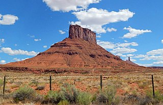
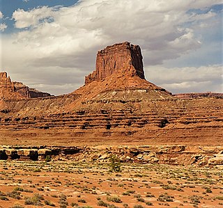
Parriott Mesa is a 6,155 ft sandstone summit in Grand County of Utah, United States. Parriott Mesa is located at Castle Valley, Utah, near the city of Moab. The name honors Dale M. Parriott (1885–1958), who was a Moab settler, and owned a ranch house in Castle Valley. Parriott Mesa is a thin 0.4 mile wide, and 1.5 mile long north-to-south mesa with 400 ft vertical Wingate Sandstone walls. Precipitation runoff from the mesa drains into the Colorado River which is about a mile away. The nearest higher peak is The Priest, 1.76 miles (2.83 km) to the east.

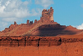
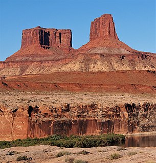
The Rectory is a 6,565-ft sandstone summit in Grand County of Utah, United States. The Rectory is located at Castle Valley, Utah, near the city of Moab. The Rectory is a thin 200 feet wide, and 1,000 feet long north-to-south butte with 200 ft vertical Wingate Sandstone walls tower standing on a 1,000 foot Moenkopi-Chinle base. Precipitation runoff from The Rectory drains into the nearby Colorado River. The nearest higher peak is Castleton Tower, 0.35 miles (0.56 km) to the south. Priest and Nuns are towers immediately north and part of The Rectory. Further northwest along the connecting ridge is The Convent, with a rock tower called Sister Superior between the two. The first ascent was made May 22, 1962, by Harvey Carter and Cleve McCarty via Empirical Route. Harvey Carter named this geological feature.
Convent Mesa, or The Convent, or simply Convent, are alternative names for a 5,955-foot eevation sandstone summit in Grand County of Utah, United States. The Convent is located in Professor Valley, near the city of Moab. It is situated northeast of Parriott Mesa and southwest of the Fisher Towers area. The Convent is a 1,000 feet wide, and 3,000 feet long northwest-to-southeast trending butte with 400-ft vertical Wingate Sandstone walls. The nearest higher peak is Sister Superior, 0.91 miles (1.46 km) to the southeast. Further southeast along the connecting ridge are The Rectory and Castleton Tower. Precipitation runoff from The Convent drains into the nearby Colorado River. The first ascent of Convent was made in November 1965 by Harvey Carter and Steve Miller via the Salvation Chimney climbing route.

Mount Spry is a small 5,720-ft elevation mountain summit made of Navajo Sandstone located in Zion National Park, in Washington County of southwest Utah, United States. Officially named in 1934, it honors William Spry (1864-1929), the third governor of Utah. The nearest higher peak is The East Temple, 0.34 miles (0.55 km) to the east. Precipitation runoff from the mountain drains into tributaries of the North Fork Virgin River.

The East Temple is a prominent 7,709 feet (2,350 m) summit composed of Navajo Sandstone in Zion National Park, in Washington County of southwest Utah, United States. It is one of the notable landmarks in the park. The nearest neighbor is Twin Brothers, one-half mile to the north, and the nearest higher peak is The West Temple, 3.85 miles (6.20 km) to the west-southwest. The mountain is situated 1.8 miles northeast of the park headquarters, at the confluence of Pine Creek and the North Fork Virgin River. This feature's name was applied by John Wesley Powell during his explorations in 1872, and was officially adopted in 1934 by the U.S. Board on Geographic Names. The first ascent was made in 1937 by Glen Dawson, Dick Jones, Homer Fuller, Wayland Gilbert, and Jo Momyer.

The West Temple is a prominent 7,810-foot mountain summit composed of Navajo Sandstone in Zion National Park in Washington County of Utah, United States. This, the highest feature in Zion Canyon, was originally called "Temp-o-i-tin-car-ur" meaning "Mountain without a trail" by the Paiute people. It was called Steamboat Mountain by local Mormon settlers before 1934, when the USGS officially changed it to its present name, which was applied by John Wesley Powell during his explorations in 1872. West Temple is situated two miles northwest of Springdale, Utah, one mile northeast of Mount Kinesava, and two miles west of the park headquarters. It is one of the notable landmarks in the park. The nearest higher peak is Windy Peak, 10.46 miles (16.83 km) to the north. Precipitation runoff from the mountain drains into tributaries of the Virgin River.
Sister Superior is a 6,037 ft elevation sandstone summit located southeast of The Convent in Grand County of Utah, United States. Sister Superior is located between Professor Valley and Castle Valley, near the city of Moab. It is situated east of Parriott Mesa and southwest of the Fisher Towers area. Remnants of an eroded butte, Sister Superior is a thin tower with 300+ ft vertical Wingate Sandstone walls standing on a 1,000 foot Moenkopi-Chinle base. The nearest higher peak is The Rectory, 1.2 miles (1.9 km) to the south. Further south along the connecting ridge is Castleton Tower. Precipitation runoff from Sister Superior drains into the nearby Colorado River. The first ascent was made May 17, 1965, by Harvey Carter and David Bentley.

Monster Tower is a 600-foot (180-meter) tall sandstone tower located in the Island in the Sky District of Canyonlands National Park, in San Juan County, Utah. It is situated 300 feet southeast of Washer Woman, which is a towering arch nearly as high. Washer Woman is so named because the feature gives the appearance of a woman bent over a washtub. Monster and Washer Woman are an eroded fin composed of Wingate Sandstone, which is the remains of wind-borne sand dunes deposited approximately 200 million years ago in the Late Triassic. The nearest higher neighbor is Aztec Butte, 2 mi (3.2 km) to the west-northwest, Airport Tower is set 1.6 mi (2.6 km) to the east, and Mesa Arch is situated 1.5 mi (2.4 km) to the west. A short hike to Mesa Arch provides the easiest view of Monster Tower. Access to the tower is via the four-wheel drive White Rim Road, which is the other way to see Monster. The top of this geological formation rises 1,400 feet above the road in approximately one mile. Precipitation runoff from Monster Tower drains southeast into the nearby Colorado River via Buck Canyon.

Candlestick Tower is a 450-foot (140-meter) tall sandstone butte located in the Island in the Sky District of Canyonlands National Park, in San Juan County, Utah. Its descriptive name is from its resemblance to a candlestick. Candlestick Tower is composed of Wingate Sandstone, which is the remains of wind-borne sand dunes deposited approximately 200 million years ago in the Late Triassic. The nearest higher neighbor is Shaft Benchmark, 2 mi (3.2 km) to the east, Upheaval Dome is set 3 mi (4.8 km) to the north, and the Green River Overlook is situated 2.5 mi (4.0 km) to the east. Access to the tower is via the four-wheel drive White Rim Road. Candlestick is situated north of Soda Springs Basin and south of Holeman Spring Basin, and the top of this geological formation rises 1,400 feet above the White Rim Road in approximately one mile. Precipitation runoff from Candlestick Tower drains into the nearby Green River via these two basins.

The Witch Head is a 7,340-foot (2,237-meter) elevation white Navajo Sandstone summit located in Zion National Park, in Washington County of southwest Utah, United States. The Witch Head is situated in the "Towers of the Virgin", 2.5 mi (4.0 km) west of Zion's park headquarters, towering 3,300-feet above the floor of Zion Canyon and the Virgin River which drains precipitation runoff from this mountain. Its neighbors include The West Temple, The Sundial, Altar of Sacrifice, Meridian Tower, Bee Hive, and Three Marys. The first ascent of this feature was made in early March 1997 by Dan Stih and Ron Raimonde via the west face, which they rated a class 5.10 climb.

Owl Rock is a 6,547-foot elevation sandstone summit located south of Monument Valley, in northeast Arizona. It is situated 7 miles (11 km) north of Kayenta on Navajo Nation land, and can be seen from Highway 163 perched on the east edge of Tyende Mesa, where it towers 1,000 feet above the surrounding terrain. The descriptive name stems from its uncanny resemblance to an owl when viewed from the east. Its nearest higher neighbor is Agathla Peak, 1.4 miles (2.3 km) to the east-northeast, on the opposite side of this highway. Precipitation runoff from this feature drains into El Capitan Wash, which is part of the San Juan River drainage basin. The first ascent of Owl Rock was made in April 1966 by Fred Beckey and Harvey Carter by climbing cracks on the west face, and then bolting up a smooth south nose to the summit. They employed 20 pitons and 14 bolts on this route called Warpath. This Owl Rock is not to be confused with another located in Arches National Park in Utah.
Airport Tower is a 700-foot (210-meter) tall sandstone butte located in the Island in the Sky District of Canyonlands National Park, in San Juan County, Utah. It is situated 1.64 mile east of Washer Woman, which is a towering arch similar in height. Each are composed of Wingate Sandstone, which is the remains of wind-borne sand dunes deposited approximately 200 million years ago in the Late Triassic. The nearest higher neighbor is Monster Tower, 1.6 mi (2.6 km) to the west, and Mesa Arch is situated 3.2 mi (5.1 km) to the west. A short hike to Mesa Arch provides the easiest view of Airport Tower. Access to this tower is via the four-wheel drive White Rim Road, which is another option to see Airport Tower. The top of this geological formation rises 1,400 feet above the road in less than one mile. Precipitation runoff from Airport Tower drains southeast into the nearby Colorado River via Buck and Lathrop Canyons. This geographical feature's name was officially adopted in 1986 by the U.S. Board on Geographic Names. It was so named because the rock formation resembles the appearance of an airport control tower.

Ant Hill is a 6,641-foot (2,024-meter) elevation summit located in Zion National Park, in Washington County of southwest Utah, United States. It is composed of white Navajo Sandstone, and rises 1400-feet above the Zion – Mount Carmel Highway. Ant Hill is situated 1.65 mi (2.66 km) east-northeast of The East Temple, and 2.4 mi (3.9 km) west-northwest of Checkerboard Mesa. Precipitation runoff from this mountain drains into tributaries of the Virgin River. Despite its benign name, an ascent of this mountain is a dangerous and exposed climb.

Zeus and Moses, variant Moses and Zeus, is a 500-foot (150-meter) tall sandstone formation located in the Island in the Sky District of Canyonlands National Park, in San Juan County, Utah. These rock towers' names refer to Zeus, god of Roman mythology, and Moses, an important prophet of several religions. Zeus and Moses is composed of Wingate Sandstone, which is the remains of wind-borne sand dunes deposited approximately 200 million years ago in the Late Triassic. This formation is situated in Taylor Canyon, 3 mi (4.8 km) north-northeast of Upheaval Dome. Access to the towers is via the four-wheel drive White Rim Road, and a spur road into Taylor Canyon. The top of this geological formation rises 900 feet above the canyon floor at road's end, approximately one-half mile away. Precipitation runoff from Zeus and Moses drains into the nearby Green River via Taylor Canyon.

The Pulpit is a 4,600-foot (1,400 m) elevation Navajo Sandstone pillar located in Zion National Park, in Washington County of southwest Utah, United States. The Pulpit is situated in the Temple of Sinawava at the north end of Zion Canyon, rising 160-feet above the canyon floor and the North Fork of the Virgin River which drains precipitation runoff from this rock. It is a photographic icon seen from the parking area at the end of Zion Canyon Scenic Drive, and the entrance to The Narrows. Neighbors include Mountain of Mystery to the north, Observation Point to the southeast, Angels Landing and The Organ to the south, and Cathedral Mountain to the southwest. The first ascent was made April 15, 1967, by Fred Beckey, Eric Bjornstad, Hal Woodworth, Pat Callis, and Galen Rowell.
Buttes of the Cross is two sandstone summits located in the northern reach of Glen Canyon National Recreation Area, in Wayne County of Utah, United States. The larger and higher south butte reaches an elevation of 5,642 feet, whereas the north butte rises to 5,569 feet, with approximately 0.6 mile separation between them. When viewed from the north-northeast near Labyrinth Canyon, they align to form the shape of a cross, creating the appearance of a single butte. The name "Butte of the Cross" was first applied by John Wesley Powell during the Powell Geographic Expedition of 1869. A few miles further down the Green River, Powell finds that this geographical feature is two buttes when viewed from the east, so it was renamed Buttes of the Cross. Buttes of the Cross towers over 1,400 feet above its surrounding terrain. It is situated 6.8 miles west of Candlestick Tower, and one-half mile outside the boundary of Canyonlands National Park.


