Carmel Formation

Last updated
Carmel Formation
Stratigraphic range: Bajocian–Callovian
Carmel Formation at type area.jpg
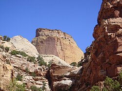
Carmel Formation at its type location, Mount Carmel, Utah
Type Geological formation
Unit of San Rafael Group
Underlies Entrada Sandstone
Overlies Navajo Sandstone, Temple Cap Formation, Nugget Sandstone
ThicknessFrom 200 feet (60 m) to 1,000 feet (300 m) [1]
Lithology
PrimaryMudstone
OtherSandstone, siltstone, limestone
Location
Coordinates 37°15′04″N112°39′47″W / 37.251°N 112.663°W / 37.251; -112.663
RegionWyoming, Utah, Colorado, north east Arizona and New Mexico
CountryUS
Type section
Named forMount Carmel
Named byGilluly and Reeside
Year defined1928
Usa edcp relief location map.png
Cyan pog.svg
Carmel Formation (the United States)
USA Utah relief location map.svg
Cyan pog.svg
Carmel Formation (Utah)
Carmel Formation exposed at Gunlock Reservoir, southwestern Utah CarmelGunlock.jpg
Carmel Formation exposed at Gunlock Reservoir, southwestern Utah
Carmel Formation near Gunlock, Utah. The unconformably overlying dark unit is the Upper Cretaceous Iron Springs Formation. CarmelGunlock2.jpg
Carmel Formation near Gunlock, Utah. The unconformably overlying dark unit is the Upper Cretaceous Iron Springs Formation.

The Carmel Formation is a geologic formation in the San Rafael Group that is spread across the U.S. states of Wyoming, Utah, Colorado, north east Arizona and New Mexico. Part of the Colorado Plateau, this formation was laid down in the Middle Jurassic during the late Bajocian, through the Bathonian and into the early Callovian stages. [2]

Contents

Description

The Carmel Formation consists of up to 1,000 feet (300 m) of mudrock and sandstone interbedded with limestone and gypsum. It was laid down in a shallow marine to sabkha environment, [1] into which terrigenous sediment was periodically carried. This gives the formation considerable lithological complexity. [3] The formation is underlain by the Navajo Sandstone, with the regional J-2 unconformity separating the two formations, or by the Temple Cap Formation. Portions of the Carmel Formation grade laterally eastward into the Page Sandstone. [2] The Carmel Formation in turn is overlain by the Entrada Formation. [3]

In the type area of southern Utah, the Carmel Formation is divided into the Judd Hollow Member, a basal limestone member; the Crystal Creek Member, mostly mudstone and siltstone, which grades into the Page Sandstone to the east; the Paria River Member, which is also siltstone and mudstone but is separated from the Crystal Creek Member by gypsum beds; and the Winsor Member, which is mudstone, sandstone, and siltstone separated from the Paria River by a basal limestone. Further east, the limestone marker bed pinches out, and the Winsor Member and Paria River Member become indistinguishable and are informally termed the upper member. The upper member contains volcaniclastic beds of rhyolite originating in a volcanic arc just off the edge of the Colorado Plateau. [4]

The formation preserves a Jurassic hardground, rare for North America. [5]

Subunits

Members (alphabetical):

(Asterisks mean the name is used by the US Geological Survey). [9]

History of investigation

The Golden Throne, a rock formation in Capitol Reef National Park. Though the park is famous for white domes of the Navajo Sandstone, this dome's color is a result of a lingering section of yellow Carmel Formation carbonate, which has stained the underlying rock. GoldenThrone.JPG
The Golden Throne, a rock formation in Capitol Reef National Park. Though the park is famous for white domes of the Navajo Sandstone, this dome's color is a result of a lingering section of yellow Carmel Formation carbonate, which has stained the underlying rock.

In 1928 Gilluly and Reeside stated an intent to name the formation after the village of Mount Carmel, Utah but did not give a type locality. They noted it as a basal formation in the San Rafael Group in San Rafael Swell, in Emery County, Utah. [10] An overview along with a type locality and source of name was stated by Gregory and Moore in 1931. [11] Mackin revised the formation's description and assigned the Homestake Limestone Member to it in 1954. [12] Harshbarger and others created an overview in 1957. [13] Its eastern areal limits were described by Wright and others in 1962. [14] In 1963, western areal limits along with an overview were completed by Schultz and Wright. [15] Another revision was done by Phoenix in 1963 who also added a Judd Hollow Tongue member. [16] Isotopic dating was conducted by Marvin and others in 1965. The Kolob, Crystal Creek, Paria River, Winsor, and Wiggler Wash members were assigned by Thompson and Stokes in 1970. Areal limits were adjusted by O'Sullivan and Craig in 1973 [17] and again in 1983 by Blakey and others. [3] An overview was completed by Chapman in 1989. [4] Hintze and others conducted isotopic dating and created an overview in 1994. [18]

Paleontological finds

There have been a number of paleontological finds within the Carmel Formation. Among these have been bryozoans, [19] oysters, [5] and dinosaur footprints. [20]

Hardground mollusc community

The formation preserves a rare Jurassic hardground interpreted as a carbonate lagoon between oolitic shoals and a subtidal zone. The hardground community was dominated by bivalves such as Liostrea , Plicatula , and Modiolus . The ichnofossil Gastro‐chaenolites is present, often with fossils of Lithophaga preserved inside. The rare bryozoan Arachnidium is found in attachment scars of Liostrea. Though bivalves were abundant, the community is lacking in the diversity seen in other Jurassic hardgrounds, suggesting a restricted shelf environment. [5]

Bryozoans

Bryozoans found within the Carmel Formation include seven species of calcareous cyclostome bryozoans as well as a soft-bodied ctenostome bryozoan. [19]


Places found

Geologic Province: [9]

Related Research Articles

<span class="mw-page-title-main">Entrada Sandstone</span> Geological formation in Utah, USA

The Entrada Sandstone is a formation in the San Rafael Group found in the U.S. states of Wyoming, Colorado, northwest New Mexico, northeast Arizona, and southeast Utah. Part of the Colorado Plateau, this formation was deposited during the Jurassic Period sometime between 180 and 140 million years ago in various environments, including tidal mudflats, beaches, and sand dunes. The Middle Jurassic San Rafael Group was dominantly deposited as ergs in a desert environment around the shallow Sundance Sea.

<span class="mw-page-title-main">Geology of the Zion and Kolob canyons area</span> Geology of Zion National Park in Utah

The geology of the Zion and Kolob canyons area includes nine known exposed formations, all visible in Zion National Park in the U.S. state of Utah. Together, these formations represent about 150 million years of mostly Mesozoic-aged sedimentation in that part of North America. Part of a super-sequence of rock units called the Grand Staircase, the formations exposed in the Zion and Kolob area were deposited in several different environments that range from the warm shallow seas of the Kaibab and Moenkopi formations, streams and lakes of the Chinle, Moenave, and Kayenta formations to the large deserts of the Navajo and Temple Cap formations and dry near shore environments of the Carmel Formation.

The exposed geology of the Bryce Canyon area in Utah shows a record of deposition that covers the last part of the Cretaceous Period and the first half of the Cenozoic era in that part of North America. The ancient depositional environment of the region around what is now Bryce Canyon National Park varied from the warm shallow sea in which the Dakota Sandstone and the Tropic Shale were deposited to the cool streams and lakes that contributed sediment to the colorful Claron Formation that dominates the park's amphitheaters.

<span class="mw-page-title-main">Geology of the Capitol Reef area</span>

The exposed geology of the Capitol Reef area presents a record of mostly Mesozoic-aged sedimentation in an area of North America in and around Capitol Reef National Park, on the Colorado Plateau in southeastern Utah.

<span class="mw-page-title-main">Morrison Formation</span> Rock formation in the western United States

The Morrison Formation is a distinctive sequence of Upper Jurassic sedimentary rock found in the western United States which has been the most fertile source of dinosaur fossils in North America. It is composed of mudstone, sandstone, siltstone, and limestone and is light gray, greenish gray, or red. Most of the fossils occur in the green siltstone beds and lower sandstones, relics of the rivers and floodplains of the Jurassic period.

<span class="mw-page-title-main">Cutler Formation</span> Geologic formation in the Four Corners, US

The Cutler Formation or Cutler Group is a rock unit that is exposed across the U.S. states of Arizona, northwest New Mexico, southeast Utah and southwest Colorado. It was laid down in the Early Permian during the Wolfcampian epoch.

<span class="mw-page-title-main">Moenkopi Formation</span> Geologic formation in the southwestern United States

The Moenkopi Formation is a geological formation that is spread across the U.S. states of New Mexico, northern Arizona, Nevada, southeastern California, eastern Utah and western Colorado. This unit is considered to be a group in Arizona. Part of the Colorado Plateau and Basin and Range, this red sandstone was laid down in the Lower Triassic and possibly part of the Middle Triassic, around 240 million years ago.

<span class="mw-page-title-main">Chinle Formation</span> Geological formation in the western US

The Chinle Formation is an Upper Triassic continental geological formation of fluvial, lacustrine, and palustrine to eolian deposits spread across the U.S. states of Nevada, Utah, northern Arizona, western New Mexico, and western Colorado. In New Mexico, it is often raised to the status of a geological group, the Chinle Group. Some authors have controversially considered the Chinle to be synonymous to the Dockum Group of eastern Colorado and New Mexico, western Texas, the Oklahoma panhandle, and southwestern Kansas. The Chinle Formation is part of the Colorado Plateau, Basin and Range, and the southern section of the Interior Plains. A probable separate depositional basin within the Chinle is found in northwestern Colorado and northeastern Utah. The southern portion of the Chinle reaches a maximum thickness of a little over 520 meters (1,710 ft). Typically, the Chinle rests unconformably on the Moenkopi Formation.

<span class="mw-page-title-main">Glen Canyon Group</span> Group of geologic formations in the Colorado Plateau, USA

The Glen Canyon Group is a geologic group of formations that is spread across the U.S. states of Nevada, Utah, northern Arizona, north west New Mexico and western Colorado. It is called the Glen Canyon Sandstone in the Green River Basin of Colorado and Utah.

The San Rafael Group is a geologic group or collection of related rock formations that is spread across the U.S. states of New Mexico, Arizona, Utah and Colorado. As part of the Colorado Plateau, this group of formations was laid down in the Middle Jurassic during the Bajocian, Bathonian and Callovian Stages.

<span class="mw-page-title-main">San Juan Basin</span> Structural basin in the Southwestern United States

The San Juan Basin is a geologic structural basin located near the Four Corners region of the Southwestern United States. The basin covers 7,500 square miles and resides in northwestern New Mexico, southwestern Colorado, and parts of Utah and Arizona. Specifically, the basin occupies space in the San Juan, Rio Arriba, Sandoval, and McKinley counties in New Mexico, and La Plata and Archuleta counties in Colorado. The basin extends roughly 100 miles (160 km) N-S and 90 miles (140 km) E-W.

<span class="mw-page-title-main">Carbonate hardgrounds</span>

Carbonate hardgrounds are surfaces of synsedimentarily cemented carbonate layers that have been exposed on the seafloor. A hardground is essentially, then, a lithified seafloor. Ancient hardgrounds are found in limestone sequences and distinguished from later-lithified sediments by evidence of exposure to normal marine waters. This evidence can consist of encrusting marine organisms, borings of organisms produced through bioerosion, early marine calcite cements, or extensive surfaces mineralized by iron oxides or calcium phosphates. Modern hardgrounds are usually detected by sounding in shallow water or through remote sensing techniques like side-scan sonar.

<span class="mw-page-title-main">Summerville Formation</span> Geologic formation in Four Corners region, US

The Summerville Formation is a geological formation in New Mexico, Colorado, and Utah of the Southwestern United States. It dates back to the Oxfordian stage of the Late Jurassic.

<span class="mw-page-title-main">Mancos Shale</span> Late Cretaceous geologic formation of the Western United States

The Mancos Shale or Mancos Group is a Late Cretaceous geologic formation of the Western United States.

<span class="mw-page-title-main">Supai Group</span> Section of red bed deposits at the Colorado Plateau

The Supai Group is a slope-forming section of red bed deposits found in the Colorado Plateau. The group was laid down during the Pennsylvanian to Lower Permian. Cliff-forming interbeds of sandstone are noticeable throughout the group. The Supai Group is especially exposed throughout the Grand Canyon in northwest Arizona, as well as local regions of southwest Utah, such as the Virgin River valley region. It occurs in Arizona at Chino Point, Sycamore Canyon, and famously at Sedona as parts of Oak Creek Canyon. In the Sedona region, it is overlain by the Hermit Formation, and the colorful Schnebly Hill Formation.

<span class="mw-page-title-main">Burro Canyon Formation</span> Geologic formation in the southwestern US

The Burro Canyon Formation is an Early Cretaceous Period sedimentary geologic formation, found in western Colorado, the Chama Basin and eastern San Juan Basin of northern New Mexico, and in eastern Utah, US.

<span class="mw-page-title-main">Curtis Formation</span>

The Curtis Formation is a geologic formation in Utah. It preserves fossils dating back to the Callovian age of the Jurassic period.

The Halgaito Formation is the basal Permian geologic member of the Cutler Group in southern Utah. The member consists of silty sandstone, siltstone and limestone. The Elephant Canyon may grade into the Halgaito and grades northward into the Cedar Mesa Formation.

<span class="mw-page-title-main">Bluff Formation</span> Geologic formation in the western United States

The Bluff Formation is a geological formation found in the Four Corners area. It was deposited in the late Jurassic Period.

The Molas Formation is a geologic formation that is found in the Four Corners region of the United States. Its age is poorly constrained but is thought to be Namurian.

References

  1. 1 2 "Carmel Formation (in San Rafael Group)". 6 September 2015. Archived from the original on 4 March 2016. Retrieved 6 September 2015.
  2. 1 2 3 4 5 6 Peterson, F.; Pipiringos, G.N. (1979). "Stratigraphic relations of the Navajo Sandstone to Middle Jurassic formations, southern Utah and northern Arizona". United States Geological Survey Professional Paper. 1035-B. doi: 10.3133/pp1035B .
  3. 1 2 3 Blakey, R.C.; Peterson, Fred; Caputo, M.V.; Voorhees, B.J.; Geddes, D.J.; Geesaman, R.C. (1983). "Paleogeography of Middle Jurassic continental, shoreline, and shallow marine sedimentation, southern Utah". Society of Economic Paleontologists and Mineralogists, Rocky Mountain Section, Rocky Mountain Paleogeography Symposium. 2: 77–100. Retrieved 26 October 2021.
  4. 1 2 Chapman, Mary G. (1 March 1989). "Implications of rhyolitic ignimbrite boulders in the Middle Jurassic Carmel Formation of southern Utah". Geology. 17 (3): 281–284. doi:10.1130/0091-7613(1989)017<0281:IORIBI>2.3.CO;2.
  5. 1 2 3 Wilson, Mark A.; Palmer, Timothy J. (January 1994). "A carbonate hardground in the Carmel Formation (middle Jurassic, SW Utah, USA) and its associated encrusters, borers and nestlers". Ichnos. 3 (2): 79–87. doi:10.1080/10420949409386375.
  6. 1 2 Doelling, H.H.; Davis, F.D. (1989). "The geology of Kane County, Utah". Utah Geological and Mineral Survey Bulletin. 124. Retrieved 25 October 2021.
  7. Leith, C.K.; Harder, E.C. (1908). "The iron ores of the Iron Springs district, southern Utah". United States Geological Survey Bulletin. 338. doi: 10.3133/b338 . hdl: 2346/64975 .
  8. 1 2 3 Thompson, A.E.; Stokes, W.L. (1970). "Stratigraphy of the San Rafael Group, southwest and south central Utah". Utah Geological and Mineral Survey Bulletin. 87.
  9. 1 2 GEOLEX database entry for Carmel, USGS (viewed 20 March 2006)
  10. Gilluly, J.; Reeside, J.B. Jr. (1928). "Sedimentary rocks of the San Rafael Swell and some adjacent areas in eastern Utah". United States Geological Survey Professional Paper. 150-D: 73–76. doi: 10.3133/pp150D .
  11. Gregory, H.C.; Moore, R.C. (1931). "The Kaiparowits Region: A Geographic and Geologic Reconnaissance of Parts of Utah and Arizona". United States Geological Survey Professional Paper. 164: 72–77. doi: 10.3133/pp164 . hdl: 2027/uc1.32106006462755 .
  12. Mackin, J.H. (1954). "Geology and iron ore deposits of the Granite Mountain area, Iron County, Utah". U.S. Geological Survey Miscellaneous Field Studies Map. MF-I4. doi:10.3133/mf14.
  13. Harshbarger, J.W.; Repenning, C.A.; Irwin, J.H. (1957). "Stratigraphy of the uppermost Triassic and the Jurassic rocks of the Navajo country". United States Geological Survey Professional Paper. 291. doi: 10.3133/pp291 .
  14. Wright, J.C.; Shawe, D.R.; Lohman, S.W. (1962). "Definition of Members of Jurassic Entrada Sandstone in East-Central Utah and West-Central Colorado". AAPG Bulletin. 46. doi:10.1306/BC74394B-16BE-11D7-8645000102C1865D.
  15. Schultz, L.G.; Wright, J.C. (1963). "Bentonite beds of unusual composition in the Carmel Formation, southwest Utah". U.S. Geological Survey Professional Paper. 450-E (198): E67–E72. doi: 10.3133/pp450E .
  16. Phoenix, D.A. (1963). "Geology of the Lees Ferry area, Coconino County, Arizona". United States Geological Survey Bulletin. 1137: 32–35. doi: 10.3133/b1137 .
  17. Marvin, R.F.; Wright, J.C.; Walthall, F.G. (1965). "K-Ar and Rb-Sr ages of biotite from the Middle Jurassic part of the Carmel Formation, Utah". United States Geological Survey Professional Paper. 525-B: B104–B107. doi: 10.3133/pp525B .
  18. Hintze, L.F.; Anderson, R.E.; Embree, G.F. (1994). "Geologic map of the Motoqua and Gunlock quadrangles, Washington County, Utah". U.S. Geological Survey Miscellaneous Investigations Series Map. I-2427. Retrieved 26 October 2021.
  19. 1 2 Taylor, Paul D.; Wilson, Mark A. (September 1999). "Middle Jurassic bryozoans from the Carmel Formation of southwestern Utah". Journal of Paleontology. 73 (5): 816–830. doi:10.1017/S0022336000040671.
  20. Lockley, Martin; Hunt, Adrian; Paquette, Marc; Bilbey, Sue‐Ann; Hamblin, Alden (July 1998). "Dinosaur tracks from the Carmel formation, northeastern Utah: Implications for middle Jurassic paleoecology". Ichnos. 5 (4): 255–267. doi:10.1080/10420949809386424.
  21. 1 2 O'Sullivan, R.B.; Craig, L.C. (1973). "Jurassic rocks of northeast Arizona and adjacent areas" (PDF). New Mexico Geological Society Field Conference Guidebook. 24: 79–85. Retrieved 25 October 2021.
  22. Rowley, P.D.; Hansen, W.R. (1979). "Geologic map of the Plug Hat quadrangle, Moffat County, Colorado". U.S. Geological Survey Geologic Quadrangle Map. GQ-1514. Retrieved 25 October 2021.