Uinta Formation

Last updated
Uinta Formation
Stratigraphic range: Eocene
Uinta Formation, Uintah County, Utah.jpg
Characteristic exposure of the Uinta Formation
Type Formation
Lithology
Primary mudstones and sandstone
Other gilsonite
Location
Region Utah
Country United States
Mudstones of the Uinta Formation (Uinta "C"), Uintah County, Utah. Uinta C.jpg
Mudstones of the Uinta Formation (Uinta "C"), Uintah County, Utah.
Uinta Formation (Uinta "C"), Uintah County, Utah Uinta C (2).jpg
Uinta Formation (Uinta "C"), Uintah County, Utah

The Uinta Formation is a geologic formation in northeastern Utah. The name appears on a geologic map accompanying the Clarence King Fortieth Parallel report for 1876 [1] but not defined until 1878 [2] as the Uinta Group. As defined, it consisted of all Tertiary strata overlying the Green River Formation and was composed of coarse, conglomeratic sandstones, passing up into finer-grained sandstones and calcareous mudstones. Numerous vertebrate fossils were collected and described by Othniel C. Marsh of Yale University. The formation was subsequently subdivided into three informal horizons (A, B, C) based on mammalian fossils. [3] Horace Wood [4] proposed the name Wagonhound Member (from Wagonhound Canyon) for Uinta A+B and Myton Member (from the town of Myton) for Uinta C. However, these names are not based on lithology, but on mammalian vertebrate faunas. For that reason, they have not been accepted as proper lithostratigraphic names.

Members of the Uinta Formation

Gilsonite, Gottonwood Dike intruded in the Uinta Formation Pencillated gilsonite (Cottonwood Dike intruded in the Uinta Formation, Middle Eocene; south-southeast of Ouray, Utah, USA) 7.jpg
Gilsonite, Gottonwood Dike intruded in the Uinta Formation

Today the formation is subdivided into three informal members: [5]

Member A: Yellowish-gray and yellowish-brown, fine- to very fine grained sandstone and siltstone, with minor amounts of conglomerate, shale, and tuffaceous beds. It intertongues with the underlying Parachute Creek Member of the Green River Formation. It has produced a K-Ar radiometric date 43 Ma.

Member B: Light-gray, light-greenish-gray, light-brown, and light-purple, mudstone and claystone with interbeds of greenish-gray, yellow, and brown fine-grained sandstone, and minor conglomerate and tuffaceous beds. Much of the gilsonite comes from this member in the southern part of the Uinta Basin.

Member C: Soft, light-gray, greenish-gray, white, grayish-purple, red, and pale-yellow shale, mudstone, claystone, and minor sandstone with local tuffaceous interbeds. The eroded sandstones form the strange shaped hoodooes at Fantasy Canyon.

Mammalian Biostratigraphy

Fossil mammals from the Uinta formation define the Uintan North American Land Mammal Age. [6] The index taxa include: Achaenodon, Amynodon, Diplacodon, Eobasileus, Leptotragulus, Oxyaenodon, Oromeryx, Prodaphænus, Protitanotherium, Protoptychus, Dolichorhinus (= Sphenocoelus), Ourayia, Procynodictis, Metarhinus, Mesomeryx, Bunomeryx, Hylomeryx, and Mytonomeryx. [7] During this interval, primates decline in diversity and relative abundance, primitive perissodactyls were replaced by more advanced forms, such as the Amynododontidae, new artiodactyls appeared, including Oromerycidae, Camelidae, Agriochoeridae, and Protoceratidae. Among rodents, Cylindrodontidae and Eomyidae replaced the Ischyromydidae, and rabbits make their first appearance as the tropical and subtropical habitats began to be replaced by more open habitats.

More recent research has subdivided the Uintan into smaller intervals called biochronological zones (biochrons) based on distinctive suites of mammalian species: early (Ui1), middle (Ui2) and late (Ui3). [7] [8] These biochrons are based on taxa and do not correspond to the three informal members listed above.
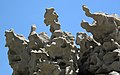
See also

Related Research Articles

Geology of the Capitol Reef area

The exposed geology of the Capitol Reef area presents a record of mostly Mesozoic-aged sedimentation in an area of North America in and around Capitol Reef National Park, on the Colorado Plateau in southeastern Utah.

Morrison Formation Rock formation in the western United States

The Morrison Formation is a distinctive sequence of Upper Jurassic sedimentary rock found in the western United States which has been the most fertile source of dinosaur fossils in North America. It is composed of mudstone, sandstone, siltstone, and limestone and is light gray, greenish gray, or red. Most of the fossils occur in the green siltstone beds and lower sandstones, relics of the rivers and floodplains of the Jurassic period.

Moenkopi Formation Geologic feature in the Southwestern United States

The Moenkopi Formation is a geological formation that is spread across the U.S. states of New Mexico, northern Arizona, Nevada, southeastern California, eastern Utah and western Colorado. This unit is considered to be a group in Arizona. Part of the Colorado Plateau and Basin and Range, this red sandstone was laid down in the Lower Triassic and possibly part of the Middle Triassic, around 240 million years ago.

Chinle Formation Geological formation in the western US

The Chinle Formation is an Upper Triassic continental geological formation of fluvial, lacustrine, and palustrine to eolian deposits spread across the U.S. states of Nevada, Utah, northern Arizona, western New Mexico, and western Colorado. The Chinle is controversially considered to be synonymous to the Dockum Group of eastern Colorado and New Mexico, western Texas, the Oklahoma panhandle, and southwestern Kansas. The Chinle is sometimes colloquially named as a formation within the Dockum Group in New Mexico and in Texas. The Chinle Formation is part of the Colorado Plateau, Basin and Range, and the southern section of the Interior Plains.

Laramie Formation

The Laramie Formation is a geologic formation of Late Cretaceous (Maastrichtian) age, named by Clarence King in 1876 for exposures in northeastern Colorado, in the United States. It was deposited on a coastal plain and in coastal swamps that flanked the Western Interior Seaway. It contains coal, clay and uranium deposits, as well as plant and animal fossils, including dinosaur remains.

The North American land mammal ages (NALMA) establishes a geologic timescale for North American fauna beginning during the Late Cretaceous and continuing through to the present. These periods are referred to as ages or intervals and were established using geographic place names where fossil materials were obtained.


The Triassic Stockton Formation is a mapped bedrock unit in Pennsylvania, New Jersey, and New York. It is named after Stockton, New Jersey, where it was first described. It is laterally equivalent to the New Oxford Formation in the Gettysburg Basin of Pennsylvania and Maryland.

Paskapoo Formation

The Paskapoo Formation is a stratigraphic unit of Middle to Late Paleocene age in the Western Canada Sedimentary Basin. The Paskapoo underlies much of southwestern Alberta, and takes the name from the Blindman River. It was first described from outcrops along that river, near its confluence with the Red Deer River north of the city of Red Deer, by J.B. Tyrrell in 1887. It is important for its freshwater aquifers, its coal resources, and its fossil record, as well as having been the source of sandstone for the construction of fire-resistant buildings in Calgary during the early 1900s.

Fantasy Canyon

Fantasy Canyon is a Bureau of Land Management-managed area located about 27 miles (43 km) south of Vernal, in Uintah County, Utah, United States.

Enon Formation Jurassic-Cretaceous geological formation in the Uitenhage Group of South Africa

The Enon Formation is a geological formation found in the Eastern and Western Cape provinces in South Africa. It is the lowermost of the four formations found within the Uitenhage Group of the Algoa Basin, its type locality, where it has been measured at a maximum thickness of 480 metres (1,570 ft). Discontinuous outcrops are also found in the Worcester-Pletmos and Oudshoorn-Gamtoos Basins, including isolated occurrences in the Haasvlakte, Jubilee, and Soutpansvlakte Basins near the small town Bredasdorp.

Brule Formation Rock formation in the western United States

The Brule Formation was deposited between 33 and 30 million years ago, roughly the Rupelian age (Oligocene). It occurs as a subunit of the White River Formation in Nebraska, Colorado, North Dakota, South Dakota, and Wyoming.

Willwood Formation

The Willwood Formation is a sedimentary sequence deposited during the late Paleocene to early Eocene, or Clarkforkian, Wasatchian and Bridgerian in the NALMA classification.

Wasatch Formation

The Wasatch Formation (Tw) is an extensive highly fossiliferous geologic formation stretching across several basins in Idaho, Montana Wyoming, Utah and western Colorado. It preserves fossils dating back to the Early Eocene period. The formation defines the Wasatchian or Lostcabinian, a period of time used within the NALMA classification, but the formation ranges in age from the Clarkforkian to Bridgerian.

San Pedro Arroyo Formation Geologic formation in New Mexico

The San Pedro Arroyo Formation is a geologic formation in south-central New Mexico. It preserves fossils dating back to the late Triassic period.

Duchesne River Formation

The Duchesne River Formation is a geologic formation in the Uintah Basin of northeastern Utah. It was originally named the Duchesne Formation by Carnegie Museum paleontologist OA Peterson, and modified to the Duchesne River Formation by Carnegie Museum paleontologist JL Kay because Duschesne Formation was previously used for a Jurassic limestone. In naming the formation, no type section was given, only that it is named for the Duchesne River, which flows roughly southeast and east to join the Green River.

Mint Canyon Formation Miocene geologic formation in the Sierra Pelona of California

The Mint Canyon Formation (Tm) is a Miocene geologic formation in the Sierra Pelona Mountains of Los Angeles County, southern California. The formation preserves fossils dating back to the Middle to Late Miocene.

The Morawan Formation is a Chattian age siliceous marine geological formation of the Oligo-Miocene Japanese Kawakami Group of eastern Hokkaido prefecture. The formation is fossil rich and contains source units where toothed baleen whales (Aetiocetidae) and Desmostylians have been discovered.

Tikitherium is an extinct genus of mammaliaforms from the Late Triassic. It is thought to be an insectivore and a close relative to Docodonta. Tikitherium refers to Tiki, the village located near the Tiki Formation where the specimen was found and therium is Greek for “Beast”. The species was named copei in honor of Edward Drinker Cope for his pioneering discoveries towards understanding mammalian molars.

Picuris Formation A geologic formation in New Mexico

The Picuris Formation is a geologic formation exposed in the eastern flank of the Rio Grande rift in northern New Mexico. It was deposited from the late Eocene to Miocene epochs.

Owl Rock

Owl Rock is a 6,547-foot elevation sandstone summit located south of Monument Valley, in northeast Arizona. It is situated 7 miles (11 km) north of Kayenta on Navajo Nation land, and can be seen from Highway 163 perched on the east edge of Tyende Mesa, where it towers 1,000 feet above the surrounding terrain. Its nearest higher neighbor is Agathla Peak, 1.4 miles (2.3 km) to the east-northeast, on the opposite side of this highway. Precipitation runoff from this feature drains into El Capitan Wash, which is part of the San Juan River drainage basin. The first ascent of Owl Rock was made in April 1966 by Fred Beckey and Harvey Carter by climbing cracks on the west face, and then bolting up a smooth south nose to the summit. They employed 20 pitons and 14 bolts on this route called Warpath. The descriptive name stems from its uncanny resemblance to an owl when viewed from the east. This feature is known as Bee 'Adizí in Navajo language meaning "spindle", and this sacred place is considered to be a spindle left behind by the Holy People. A newer name for it is Tsé Ts'óózí, meaning "Slim Rock".

References

  1. King, Clarence, 1876, Geological and topographical atlas accompanying the report of the geological exploration of the Fortieth Parallel [from the Sierra Nevada to the eastern slope of the Rocky Mountains], made by authority of the Honorable Secretary of War, under the direction of Brigadier and Brevet Major General A.A. Humphreys, Chief of Engineers, USA: Washington, D.C., U.S. Geological Exploration of the Fortieth Parallel (King), 12 sheets., See also U.S. War Dept., Chief Eng. Ann. Rpt., 1876, (U.S. 44th Cong., 2nd Sess., House of Representatives Exec. Doc. 1, pt. 2, v. 2, pt. 3) App. 2, p. 217-218
  2. King, Clarence, 1878, Systematic geology, IN Report of the Geological Exploration of the Fortieth Parallel made by order of the Secretary of War according to acts of Congress of March 2,1867, and March 3, 1869, under the direction of Brigadier and Brevet Major General A.A. Humphreys, Chief of Engineers, USA: Washington, D.C., U.S. Geological Exploration of the Fortieth Parallel (King), v. 1, 803 p.
  3. Peterson, O. A. 1919. Report upon the Material Discovered in the Upper Eocene of the Uinta Basin by Earl Douglass in the years 1908-1909, and by 0. A. Peterson in 1912. Annuals of the Carnegie Museum, v. 12 (2-4) pp. 40-168.
  4. Wood, H.E., 1934. Revision of the Hyrachyidae. Bulletin of the American Museum of Natural History v. 67, article 5, p. 181-295.
  5. Spinkle, D.A., 2006, Interim geologic map of the Vernal 30' x 60' quadrangle, Uintah and Duchesne Counties, Utah, and Moffat and Rio Blanco Counties, Colorado. Utah Geological Survey Open File Report 470. https://geology.utah.gov/map-pub/publications/#
  6. Wood, H. E., R. W. Chaney, J. Clark, E. H. Colbert, G.L. Jepsen, J.B. Reeside, and C. Stock. 1941. Nomenclature and correlation of the North American continental Tertiary. Geological Society of America Bulletin v. 52, pp. 1-48.
  7. 1 2 Robinson, P., G. F. Gunnell, S. L. Walsh, W. C. Clyde, J. E. Storer, R. K. Stucky, D. J. Froehlich, I. Ferrusquia-Villafranca, and M. C. McKenna. 2004. Wasatchian through Duchesnean biochronology; pp. 106-155 in M. O. Woodburne (ed.), Late Cretaceous and Cenozoic Mammals of North America. Columbia University Press, New York, New Yor
  8. Gunnell, G.F., Murphey, P.C., Stucky, R.K., Townsend, K.B., Robinson, P., Zonneveld, J.P., Bartels, W.S. and Albright, L.B., 2009. Biostratigraphy and biochronology of the latest Wasatchian, Bridgerian, and Uintan North American land mammal “ages”. Museum of Northern Arizona Bulletin 65, pp.279-330.