Mesilla Park, New Mexico

Last updated
Mesilla Park
Neighborhood
USA New Mexico location map.svg
Red pog.svg
Mesilla Park
Location within the state of New Mexico
Usa edcp location map.svg
Red pog.svg
Mesilla Park
Mesilla Park (the United States)
Coordinates: 32°16′33″N106°46′00″W / 32.27583°N 106.76667°W / 32.27583; -106.76667 Coordinates: 32°16′33″N106°46′00″W / 32.27583°N 106.76667°W / 32.27583; -106.76667
Country United States
State New Mexico
County Doña Ana
Elevation
3,878 ft (1,182 m)
Population
  Total2,560
Time zone UTC-7 (Mountain (MST))
  Summer (DST) UTC-6 (MDT)
ZIP codes
88047 [1]
Area code(s) 575
GNIS feature ID899786 [2]

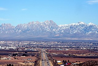
Mesilla Park, New Mexico is a unincorporated town included in the Las Cruces Metropolitan area.

History

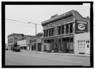
In 1880 after the Mesilla Valley was bypass by the Southern Pacific Transportation Company because they choose a more direct route South to El Paso, Texas. As a result The Atchison, Topeka and Santa Fe Railway built a line down from Albuquerque, New Mexico to Rincon, New Mexico first approached Mesilla with offers to extend the railroad lines to the town as it was the larger community, better organized, and the county seat. Residents, however, did not want to give up land for a right-of-way. Over in Las Cruces, four men founded the Las Cruces Town Company: William Rynerson, Henry Cuniffe, Simon Bolivar Newcomb, and Jacinto Armijo bought up farmland west of the town, including Armijo’s, and offered some of it to the Atchison, Topeka and Santa Fe. That sealed the deal. The railroad extend the line from Rincon, New Mexico, to El Paso, Texas, through Las Cruces, New Mexico three miles away from Mesilla, New Mexico . The first train arrived on April 26, 1881, to about as much pomp and celebration as the little town could muster. In the spring of 1887, a plan was quickly devised, and the Bowmans and Chavez sold portions of their properties to Edward Wilder, Atchison, Topeka and Santa Fe Railway Board Director, Secretary and Treasurer, stipulating that Atchison, Topeka and Santa Fe Railway would construct a depot that would stop for passengers and freight, install a telegraph operator, and that all the improvements would be made by September 1, 1887. Bowman and Chavez were investing in their land holdings, which were sold as Mesilla Park. To begin, Atchison, Topeka and Santa Fe Railway incorporated The Rio Grande Land Company on June 23, 1887 by authorizing $250,000.00 in capital stock. The Rio Grande Land Company filed the Mesilla Park townsite plat with Dona Ana County on August 25, 1887 on land on previously owned by farmers on August 25, 1887. The townsite plat filed was an irregular grid pattern of streets bounded by the meandering curvature of the old Rio Grande River to the east and south, with Sixth Street on the north now Conway Avenue, and a diagonally drawn boundary line on the west. Within the boundaries were forty-four blocks, or portions of blocks, divided into lots of varying sizes based on their use as commercial, industrial, residential, and agricultural property. Two-hundred lots were laid out ranging in size from 25 x 134 feet to several acres. Oak, Maple now Main Street, Locust now Harrelson, Linden, and Orange avenues paralleled the railroad tracks. Perpendicular to these were Union, Fourth now Bell, Fifth now Manso, and Sixth now Conway streets. The Atchison, Topeka and Santa Fe Railway was not the only factor that influenced the growth of Mesilla Park. As early as 1886, Las Cruces leaders and education advocates spoke out for the creation of an agricultural college in southern New Mexico. This resulted in the creation of the New Mexico State University on September 17, 1888. Less than a year later, the legislature authorized the creation of the University of New Mexico in Albuquerque, The School of Mines in Socorro, and The Insane Asylum in Las Vegas. New Mexico State University official opened for its first semester on January 21,1890 to the east of Mesilla Park. Now Early business during the growth included general stores, grocery stores, the original United States Post office at 3225 Main Street, Mesilla Park, New Mexico, 88047, a Wells-Fargo Express Office, Western Union Telegraph Agent, barber shop, several hotels, ice house, a wooden Atchison, Topeka and Santa Fe Railway Depo and a horse livery with blacksmith shop. In 1894, George D. Bowman filed the Bowman Addition to the Mesilla Park townsite, which expanded on the original townsite plat and added two new streets on the north, College and University avenues, and Bowman Avenue on the west. In 1906, three years after George D. Bowman's death, the Bowman Addition was amended, by his son, Henry D. Bowman, for the purpose of designating a site for a public school. The original Mesilla Park Elementary School was built on this lot beginning in 1907. In 1925 the original wooden Atchison, Topeka and Santa Fe Railway train depot was closed with the grand opening of a Spanish-Pueblo Revival-style depot that is still used today as a Burlington Northern Santa Fe maintenance office and storage yard. During the Great Depression and drought of the 1930s, New Mexico State University, dramatically expanded course offerings to include the arts and sciences along with home economics and business administration. In the 1933-1934 academic year the chemistry enrollment for a Bachelor's of Science degree was fifty percent of the total enrollment of 475. Also in the 1930s, drama, English, creative writing, and debate were offered. As the course offerings expanded, student enrollment followed with the next year to 558 students, and in the 1938-1939 academic year it increased to over one-thousand students. The college expansion resulted in a need for housing for new faculty, staff, and students in the community. In 1964 the community was annexed by "Las Cruces", when Atchison, Topeka and Santa Fe Railway, finally disconnected passengers services do to the rise in automobiles and airplane traffic. In 1970 the New Mexico section of Interstate 10 building causing one original block on the east side to be taken by intimate domain with an on ramp even being built over an original road. As of 2021 Mesilla Park still has its own post office with ZIP code 88047, which opened in 1997 at its current location at 310 East Union Avenue, Mesilla Park, New Mexico, 880047. [1] [3] [4]

Related Research Articles

Las Cruces, New Mexico City in New Mexico, United States

Las Cruces is the second-largest city in the U.S. state of New Mexico and the seat of Doña Ana County. As of the 2020 census the population was 111,385. Las Cruces is the largest city in both Doña Ana County and southern New Mexico. The Las Cruces metropolitan area had an estimated population of 213,849 in 2017. It is the principal city of a metropolitan statistical area which encompasses all of Doña Ana County and is part of the larger El Paso–Las Cruces combined statistical area.

Mesilla, New Mexico Town in New Mexico, United States

Mesilla is a town in Doña Ana County, New Mexico, United States. The population was 2,196 at the 2010 census. It is part of the Las Cruces Metropolitan Statistical Area.

U.S. Route 85 Highway in the United States

U.S. Route 85 (US 85) is a 1,479-mile-long (2,380 km) north–south United States Highway that travels in the Mountain and Northern Plains states of the United States. The southern terminus of the highway is at the Mexican border in El Paso, Texas, connecting with Mexican Federal Highway 45. The northern terminus is at the Canadian border in Fortuna, North Dakota, where the route continues north as Saskatchewan Highway 35. The highway route is part of the CanAm Highway. Sections of US 85 are designated as the Theodore Roosevelt Expressway.

Lamy station

Lamy is an Amtrak station at Santa Fe County Road 33, 152 Old Lamy Trail in Lamy, New Mexico, United States. It is served by the Southwest Chief. Until 2014, it was the southern terminus for the Santa Fe Southern Railway. The station was built in 1909 by the Atchison, Topeka and Santa Fe Railway.

Rio Grande Trail

The Rio Grande Trail is a proposed long distance trail along the Rio Grande in the U.S. state of New Mexico. The river extends over 1,800 total miles, some 700 miles (1,100 km) of which pass through the heart of New Mexico. It is the state's primary drainage feature and most valuable natural and cultural resource. The river and its bosque provide a wide variety of recreation, including hunting and fishing, birdwatching, river rafting, hiking, biking, and horseback riding. The river also flows through or beside numerous spectacular and geologically interesting landforms, the result of extensive volcanism and erosion of the valley within the Rio Grande Rift. Although some trail advocates would like to see the trail extended the full distance through New Mexico, from the Colorado border to the United States–Mexico border, the portion proposed for initial development extends 300 miles (480 km), from Bernalillo south to Las Cruces.

Raton Downtown Historic District United States historic place

The Raton Downtown Historic District is a historic district listed on the National Register of Historic Places in Raton, New Mexico, USA. The district, when first listed in 1977, is bounded on the north by Clark Avenue and on the south by Rio Grande Avenue. On the east, the district is bounded by First Street, and on the west the district is bounded by Third Street. The district covers about 200 acres (81 ha) and contains 95 significant buildings. The district was enlarged in 2015.

Atchison, Topeka and Santa Fe Passenger Depot (Colorado Springs, Colorado)

Atchison, Topeka and Santa Fe Passenger Depot or Santa Fe Station in Colorado Springs, Colorado is a historic railway station. The grand depot and Harvey House was built in 1917 as a joint Santa Fe/Colorado and Southern Railway facility. In 1972, the Santa Fe tracks through Colorado Springs were removed and rail operations were consolidated on the former Rio Grande trackage on the west side of town. The depot and the nearby express building now serves as Catalyst Campus for Technology and Innovation.

Santa Fe Depot (Santa Fe, New Mexico)

Santa Fe Depot is the northern terminus of the New Mexico Rail Runner Express commuter rail line. The station was originally built by the Atchison, Topeka and Santa Fe, and until 2014 served as the northern terminus, offices, and gift shop of the Santa Fe Southern Railway, a tourist and freight carrying short line railroad. It is located in Santa Fe, New Mexico at 410 Guadalupe Street, within an area of urban renewal referred to as the "Railyard". Rail Runner service to the station began on December 17, 2008.

The Chili Line, officially known as the Santa Fe Branch, was a 3 ft narrow-gauge branch of the Denver and Rio Grande Western Railroad (D&RGW). It ran 125.6 miles (202.1 km) from Antonito, Colorado, to Santa Fe, New Mexico. The Denver and Rio Grande Railway (D&RG) began construction of the line in 1880 and completed the line from Antonito to Española, New Mexico, but could not build any further because of an agreement with the Atchison, Topeka and Santa Fe Railroad (AT&SF). The Texas, Santa Fe and Northern Railroad was incorporated to complete the line, and the line between Española and Santa Fe opened in 1886 and was transferred to the Denver and Rio Grande shortly thereafter. The D&RGW closed the Chili Line in 1941 because of competition from road transportation, and the line was abandoned shortly thereafter.

Atchison, Topeka and Santa Fe Railway Depot, or variations with Railroad or Station or Passenger and/or Freight may refer to any one of many stations of the Atchison, Topeka and Santa Fe Railway. These include:

Monrovia station Los Angeles Metro Rail station

Monrovia is an at-grade light rail station on the L Line of the Los Angeles Metro Rail system. It is located at the intersection of Duarte Road and Myrtle Avenue in Monrovia, California, after which the station is named.

Gulf, Colorado and Santa Fe Railroad Passenger Station

Gulf, Colorado and Santa Fe Railroad Passenger Station is located on 1501 Jones Street in Fort Worth, Texas. The depot was built by the Gulf, Colorado and Santa Fe Railroad in 1900 and renovated in 1938. It was originally called the Fort Worth Union Depot. Other tenant railroads at the station were the Chicago, Rock Island and Gulf Railway, the St. Louis–San Francisco Railway ('Frisco') and the Southern Pacific Railroad.

Los Angeles and San Gabriel Valley Railroad

The Los Angeles and San Gabriel Valley Railroad was a railroad founded on Sept. 5, 1883, by James F. Crank with the goal of bringing a rail line to Pasadena from downtown Los Angeles. Los Angeles and San Gabriel Valley Railroad was sold and consolidated on May 20, 1887 into the California Central Railway. In 1889 this was consolidated into Southern California Railway Company. On Jan. 17, 1906 Southern California Railway was sold to the Atchison, Topeka and Santa Fe Railway and called the Pasadena Subdivision. The main line closed in 1994. The railroad later reopened as the MTA Gold Line Light Rail service in July 2003.

Edward Alfred Harrison, known as E. A. Harrison, was an American architect who worked as a staff architect for the Atchison, Topeka & Santa Fe Railway, with offices in Topeka, Kansas, and later in Chicago, Illinois.

State Road 478 (NM 478) is a 24.342-mile-long (39.175 km) state highway located entirely within Doña Ana County, New Mexico. Starting in Anthony and ending in Las Cruces, NM 478 was once a section of historic US 80, a major transcontinental highway between San Diego, California and Savannah, Georgia. In 1946, it also became part of U.S. Route 85, when the latter highway was extended south to the Mexican border in El Paso, Texas. US 80 and US 85 were rerouted onto a newer alignment to the east in the mid 1950s. This was also around the time the older highway was designated NM 478. For two years, the southern terminus of NM 478 also served as the national western terminus of US 80 until that highway was removed from New Mexico completely in 1991. Today, NM 478 remains on much the same route it has since it was first designated and serves several old US 80/US 85 communities long since bypassed by I-10

Atchison, Topeka and Santa Fe Railway Depot (Magdalena, New Mexico) United States historic place

The Atchison, Topeka and Santa Fe Railway Depot in Magdalena, New Mexico was listed on the National Register of Historic Places in 1978.

Railroad Avenue Historic District (Las Vegas, New Mexico) United States historic place

The Railroad Avenue Historic District is a historic district listed on the National Register of Historic Places in Las Vegas, New Mexico. It encompasses three blocks of Railroad Avenue between Jackson Street and University Avenue, as well as the first block of Lincoln Avenue. The buildings in the district were directly related to the presence of the Atchison, Topeka and Santa Fe Railway in Las Vegas and date from between 1879 and 1920.

Rio Grande Valley (New Mexico) River valley of the Rio Grande in New Mexico, United States

The Rio Grande Valley is the river valley carved out by the Rio Grande as it flows through the American Southwest and northeastern Mexico, forming a part of the border region. In the US state of New Mexico, the river flows mostly north to south, and forms a valley near Cochiti Pueblo to the state line near El Paso, Texas along the floors of the large sedimentary basins of the Rio Grande Rift, and includes the narrow sections between the basins. It has been historically settled first by the Pueblo peoples, the Spanish, the Mexicans, and finally Anglo-Americans. As the largest river in the state, some of its most populous cities are located wholly or partially in the valley, including Albuquerque, New Mexico's largest city.

References

  1. 1 2 United States Postal Service. "USPS - Look Up a ZIP Code" . Retrieved November 30, 2014.
  2. "Mesilla Park". Geographic Names Information System . United States Geological Survey.
  3. "Postmaster Finder - Post Offices by ZIP Code". United States Postal Service . Retrieved November 30, 2014.
  4. Julyan, Robert (August 26, 1996). The Place Names of New Mexico. UNM Press. p. 227. ISBN   9780826351142.