This article needs additional citations for verification .(April 2022) |
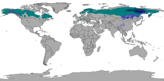
In climatology, the term microthermal is used to denote the continental climates of Eurasia and North America.
This article needs additional citations for verification .(April 2022) |
In climatology, the term microthermal is used to denote the continental climates of Eurasia and North America.
The word microthermal is derived from two Greek words meaning "small" and "heat". This is misleading, however, since the term is intended to describe only the temperature conditions that prevail during the winter months, rather than those of the entire year. [1]
Under the original Köppen climate classification, all places with an average temperature in their coldest month that is colder than -3 °C (26,4 F), are said to have a microthermal climate. The isotherm of -3 °C for the coldest monthly mean temperature, was observed to be the line where the climate was likely cold enough to support a fixed period of continuous snow cover every year.[ citation needed ] In recent usage, an isotherm of 0°C (32°F) is commonly used instead. Either definition places almost all of the world's microthermal climates in the Northern Hemisphere, as the absence of broad land masses at upper-middle latitudes in the Southern Hemisphere precludes, with few exceptions, the existence of such temperature conditions there due to the sea moderating temperatures. [2]
Microthermal climates are typically subdivided into three categories based on the temperature characteristics of the summer season. The southernmost of the three is frequently referred to as the temperate continental climate, and has hot summers — that is to say, at least one month has an average temperature of 22 °C (71.6 °F) or above. The middle zone is often labelled hemiboreal , and no summer month there has an average temperature as warm as 22 °C, but at least four months will still average at 10 °C (50 °F) or higher. The northernmost of the three microthermal zones is the subarctic, or boreal zone; there only one to three months will have average temperatures above 10 °C, bordering polar regions. [3] [4]
In North America, microthermal climates start north of Boston along the Atlantic seaboard then westward to just below the Great Lakes to the Midwest, the line then moves southward below the Dakotas, through the west near 40 latitude at the eastern edge of the Rocky Mountains, then curving northward near the lowlands of the Pacific coast, reaching the Pacific Ocean just south of Juneau, Alaska. In Asia, the latitude at which these climates begin is several degrees farther south influence of the vast Siberian anticyclone, or high-pressure system, and in continental Europe the line actually runs longitudinally rather than latitudinally, cutting through central Poland after beginning north of the Arctic Circle along the Norwegian coast, thereafter moving diagonally across Scandinavia.
The boundary between the microthermal and polar climate zones is farthest north in western Europe (actually within the Arctic Circle there), and farthest south near the northeast coast of Canada (at about 56° North latitude on the central coast of Labrador); it then trends northward across Canada before dropping south again as it courses through Alaska. Throughout most of Siberia, the boundary tends to follow the Arctic Circle fairly closely.
In addition to having various summer temperature regimes, microthermal climates also differ from one another in how much precipitation they receive — such climates may be humid, semiarid or arid. Most of the Turkestan-Gobi desert system has an arid microthermal climate, while the best-known example of the semiarid microthermal climate can be found in the "steppes of Central Asia" immortalized by Russian classical music composer Alexander Borodin.

The polar climate regions are characterized by a lack of warm summers but with varying winters. Every month a polar climate has an average temperature of less than 10 °C (50 °F). Regions with a polar climate cover more than 20% of the Earth's area. Most of these regions are far from the equator and near the poles, and in this case, winter days are extremely short and summer days are extremely long. A polar climate consists of cool summers and very cold winters, which results in treeless tundra, glaciers, or a permanent or semi-permanent layer of ice. It is identified with the letter E in the Köppen climate classification.
The subarctic climate is a continental climate with long, cold winters, and short, warm to cool summers. It is found on large landmasses, often away from the moderating effects of an ocean, generally at latitudes from 50°N to 70°N, poleward of the humid continental climates. Subarctic or boreal climates are the source regions for the cold air that affects temperate latitudes to the south in winter. These climates represent Köppen climate classification Dfc, Dwc, Dsc, Dfd, Dwd and Dsd.

In geography, the temperate climates of Earth occur in the middle latitudes, which span between the tropics and the polar regions of Earth. These zones generally have wider temperature ranges throughout the year and more distinct seasonal changes compared to tropical climates, where such variations are often small; they usually differ only in the amount of precipitation.

Verkhoyansk is a town in Verkhoyansky District of the Sakha Republic, Russia, located on the Yana River in the Arctic Circle, 92 kilometers (57 mi) from Batagay, the administrative center of the district, and 675 kilometers (419 mi) north of Yakutsk, the capital of the Sakha republic. As of the 2010 Census, its population was 1,311. Verkhoyansk holds the record for the hottest temperature ever recorded north of the Arctic Circle, with 38.0 °C (100.4 °F), and it also holds the record for the coldest temperature ever recorded in Asia, −67.8 °C (−90.0 °F). The cold record is shared with Oymyakon.

Continental climates often have a significant annual variation in temperature. They tend to occur in central and eastern parts of the three northern-tier continents, typically in the middle latitudes, often within large landmasses, where prevailing winds blow overland bringing some precipitation, and temperatures are not moderated by oceans. Continental climates occur mostly in the Northern Hemisphere due to the large landmasses found there. Most of northeastern China, eastern and southeastern Europe, much of Russia south of the Arctic Circle, central and southeastern Canada, and the central and northeastern United States have this type of climate. Continentality is a measure of the degree to which a region experiences this type of climate.

A Mediterranean climate, also called a dry summer climate, described by Köppen as Cs, is a temperate climate type that occurs in the lower mid-latitudes. Such climates typically have dry summers and wet winters, with summer conditions being hot and winter conditions typically being mild. These weather conditions are typically experienced in the majority of Mediterranean-climate regions and countries, but remain highly dependent on proximity to the ocean, altitude and geographical location.

The subtropical zones or subtropics are geographical and climate zones to the north and south of the tropics. Geographically part of the temperate zones of both hemispheres, they cover the middle latitudes from 23°26′09.9″ (or 23.43608°) to approximately 35° north and south. The horse latitudes lie within this range.
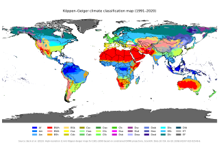
The Köppen climate classification is one of the most widely used climate classification systems. It was first published by German-Russian climatologist Wladimir Köppen (1846–1940) in 1884, with several later modifications by Köppen, notably in 1918 and 1936. Later, German climatologist Rudolf Geiger (1894–1981) introduced some changes to the classification system in 1954 and 1961, which is thus sometimes called the Köppen–Geiger climate classification.

An oceanic climate, also known as a marine climate or maritime climate, is the temperate climate sub-type in Köppen classification represented as Cfb, typical of west coasts in higher middle latitudes of continents, generally featuring cool to warm summers and cool to mild winters, with a relatively narrow annual temperature range and few extremes of temperature. Oceanic climates can be found in both hemispheres generally between 40 and 60 degrees latitude, with subpolar versions extending to 70 degrees latitude in some coastal areas. Other varieties of climates usually classified together with these include subtropical highland climates, represented as Cwb or Cfb, and subpolar oceanic or cold subtropical highland climates, represented as Cfc or Cwc. Subtropical highland climates occur in some mountainous parts of the subtropics or tropics, some of which have monsoon influence, while their cold variants and subpolar oceanic climates occur near polar or tundra regions.

The subarctic zone is a region in the Northern Hemisphere immediately south of the true Arctic, north of humid continental regions and covering much of Alaska, Canada, Iceland, the north of Fennoscandia, Northwestern Russia, Siberia, and the Cairngorms. Generally, subarctic regions fall between 50°N and 70°N latitude, depending on local climates. Precipitation is usually low, and vegetation is characteristic of the taiga.
A humid continental climate is a climatic region defined by Russo-German climatologist Wladimir Köppen in 1900, typified by four distinct seasons and large seasonal temperature differences, with warm to hot summers, and cold and snowy winters. Precipitation is usually distributed throughout the year, but often these regions do have dry seasons. The definition of this climate in terms of temperature is as follows: the mean temperature of the coldest month must be below 0 °C (32.0 °F) or −3 °C (26.6 °F) depending on the isotherm, and there must be at least four months whose mean temperatures are at or above 10 °C (50 °F). In addition, the location in question must not be semi-arid or arid. The cooler Dfb, Dwb, and Dsb subtypes are also known as hemiboreal climates. Although amount of snowfall is not a factor used in defining the humid continental climate, snow during the winter in this type of climate is almost a guarantee, either intermittently throughout the winter months near the poleward or coastal margins, or persistently throughout the winter months elsewhere in the climate zone.
In climatology, the term mesothermal is used to refer to certain forms of climate found typically in the Earth's temperate zones. It has a moderate span of temperature, with winters not cold enough to sustain snow cover. Summers are warm within oceanic climate regimes, and hot within continental or subtropical climate regimes.

Climate classifications are systems that categorize the world's climates. A climate classification may correlate closely with a biome classification, as climate is a major influence on life in a region. One of the most used is the Köppen climate classification scheme first developed in 1884.
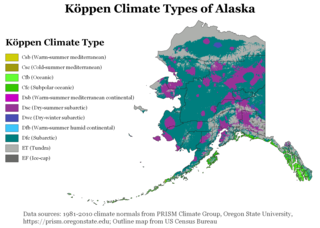
The climate of Alaska is determined by average temperatures and precipitation received statewide over many years. The extratropical storm track runs along the Aleutian Island chain, across the Alaska Peninsula, and along the coastal area of the Gulf of Alaska which exposes these parts of the state to a large majority of the storms crossing the North Pacific. The climate in Juneau and the southeast panhandle is a mid-latitude oceanic climate, in the southern sections and a subarctic oceanic climate in the northern parts. The climate in Southcentral Alaska is a subarctic climate due to its short, cool summers. The climate of the interior of Alaska is best described as extreme and is the best example of a true subarctic climate, as the highest and lowest recorded temperatures in Alaska have both occurred in the interior. The climate in the extreme north of Alaska is an Arctic climate with long, cold winters, and cool summers where snow is possible year-round.

Mohe is a county-level city in Daxing'anling Prefecture, Heilongjiang province. It is the northernmost city in China.

The climate of the United States varies due to changes in latitude, and a range of geographic features, including mountains and deserts. Generally, on the mainland, the climate of the U.S. becomes warmer the farther south one travels, and drier the farther west, until one reaches the West Coast.
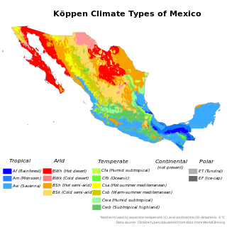
The climate of Mexico is very diverse. The Tropic of Cancer effectively divides the country into temperate and tropical zones. Land that is north of the twenty-fourth parallel experiences lower temperatures during the winter months. South of the twenty-fourth parallel, temperatures are fairly consistent all year round and vary solely as a function of elevation. The north of the country usually receives less precipitation than the south.

The climate of Norway is more temperate than could be expected for such high latitudes. This is mainly due to the North Atlantic Current with its extension, the Norwegian Current, raising the air temperature; the prevailing southwesterlies bringing mild air onshore; and the general southwest–northeast orientation of the coast, which allows the westerlies to penetrate into the Arctic. The January average in Brønnøysund is 15.8C (28.6F) higher than the January average in Nome, Alaska, even though both towns are situated on the west coast of the continents at 65°N. In July the difference is reduced to 3.2C (5.8F). The January average of Yakutsk, in Siberia but slightly further south, is 42.3C (76.1F) lower than in Brønnøysund.

The south of Sweden has a temperate climate, despite its northern latitude, with largely four distinct seasons and mild temperatures throughout the year. The winter in the far south is usually weak and is manifested only through some shorter periods with snow and sub-zero temperatures, autumn may well turn into spring there, without a distinct period of winter. The northern parts of the country have a subarctic climate while the central parts have a humid continental climate. The coastal south can be defined as having either a humid continental climate using the 0 °C isotherm, or an oceanic climate using the –3 °C isotherm.

An ice cap climate is a polar climate where no mean monthly temperature exceeds 0 °C (32 °F). The climate generally covers areas at high altitudes and polar regions, such as Antarctica and some of the northernmost islands of Canada and Russia. Most of Greenland is under the influence of an ice cap climate, although the coasts are prone to more influence from the sea, providing more tundra climates. Some regions on the islands of Norway's Svalbard Archipelago facilitate an ice cap climate. Areas with ice cap climates are normally covered by a permanent layer of ice and have no vegetation. There is limited animal life in most ice cap climates, which are usually found near the oceanic margins. Although ice cap climates are inhospitable to human life and no civilian communities lie in such climates, there are some research stations scattered in Antarctica and interior Greenland.
Unasylva - Vol.9, No. 2 - Climatic classification in forestry