Midway, Washington County, Tennessee

Last updated

Midway
USA Tennessee location map.svg
Red pog.svg
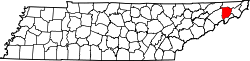
Midway
Location within the state of Tennessee
Coordinates: 36°17′39″N82°25′8″W / 36.29417°N 82.41889°W / 36.29417; -82.41889
Country United States
State Tennessee
County Washington
Area
  Total6.2 sq mi (16.0 km2)
  Land6.2 sq mi (16.0 km2)
  Water0.0 sq mi (0.0 km2)
Elevation
1,877 ft (572 m)
Population
 (2000)
  Total2,491
  Density402.1/sq mi (155.3/km2)
Time zone UTC-5 (Eastern (EST))
  Summer (DST) UTC-4 (EDT)
FIPS code 47-48630 [1]
GNIS feature ID1328901 [2]

Midway is an unincorporated community and former census-designated place (CDP) in Washington County, Tennessee. The population was 2,491 at the 2000 census; it was not counted at the 2010 census. It is part of the Johnson City Metropolitan Statistical Area, which is a component of the Johnson City-Kingsport-Bristol, TN-VA Combined Statistical Area commonly known as the "Tri-Cities" region.

Contents

The community is located on Old State Route 34, a former alignment of US Route 11E between Jonesborough and Johnson City.

Geography

Midway is located at 36°17′39″N82°25′8″W / 36.29417°N 82.41889°W / 36.29417; -82.41889 (36.294192, -82.418813). [3]

According to the United States Census Bureau, the CDP has a total area of 6.2 square miles (16 km2), all of it land.

Demographics

As of the census [1] of 2000, there were 2,491 people, 1,011 households, and 761 families residing in the CDP. The population density was 402.1 inhabitants per square mile (155.3/km2). There were 1,069 housing units at an average density of 172.6 per square mile (66.6/km2). The racial makeup of the CDP was 95.66% White, 1.69% African American, 0.32% Native American, 0.56% Asian, 0.08% Pacific Islander, 0.48% from other races, and 1.20% from two or more races. Hispanic or Latino of any race were 0.60% of the population.

There were 1,011 households, out of which 27.7% had children under the age of 18 living with them, 61.3% were married couples living together, 9.6% had a female householder with no husband present, and 24.7% were non-families. 19.7% of all households were made up of individuals, and 6.4% had someone living alone who was 65 years of age or older. The average household size was 2.46 and the average family size was 2.82.

In the CDP, the population was spread out, with 20.9% under the age of 18, 9.0% from 18 to 24, 31.4% from 25 to 44, 26.4% from 45 to 64, and 12.4% who were 65 years of age or older. The median age was 38 years. For every 100 females, there were 95.4 males. For every 100 females age 18 and over, there were 92.7 males.

The median income for a household in the CDP was $32,594, and the median income for a family was $37,716. Males had a median income of $28,661 versus $21,536 for females. The per capita income for the CDP was $15,232. About 10.9% of families and 12.4% of the population were below the poverty line, including 19.4% of those under age 18 and 8.0% of those age 65 or over.

Related Research Articles

<span class="mw-page-title-main">Crown Point, Alaska</span> Census-designated place in Alaska, United States

Crown Point is a census-designated place (CDP) in Kenai Peninsula Borough, Alaska, United States. The population was 74 at the 2010 census. Land access to this area is by either the Alaska Railroad or the Seward Highway.

<span class="mw-page-title-main">Wilhoit, Arizona</span> Census-designated place in Yavapai County, Arizona, United States

Wilhoit is a census-designated place (CDP) in Yavapai County, Arizona, United States. The population was 664 at the 2000 census.

<span class="mw-page-title-main">Solana, Florida</span> Census-designated place in Florida, United States

Solana is an unincorporated community and census-designated place (CDP) in Charlotte County, Florida, United States. The population was 671 at the 2020 census. It is part of the Sarasota-Bradenton-Punta Gorda Combined Statistical Area.

<span class="mw-page-title-main">Bloomingdale, Florida</span> Census-designated place in Florida, United States

Bloomingdale is an unincorporated census-designated place in Hillsborough County, Florida, United States. The population was 22,711 at the 2010 census. The ZIP Codes serving the community are 33511 and 33596.

<span class="mw-page-title-main">Orchidlands Estates, Hawaii</span> Census-designated place in Hawaii, U.S.

Orchidlands Estates is a census-designated place (CDP) in Hawaiʻi County, Hawaiʻi, United States located in the District of Puna. The population was 2,815 at the 2010 census, up from 1,731 at the 2000 census.

<span class="mw-page-title-main">Chesapeake Ranch Estates-Drum Point, Maryland</span> Former Census-designated place in Maryland, United States

Chesapeake Ranch Estates-Drum Point was a census-designated place in Calvert County, Maryland, for the 2000 United States Census, when it had a population of 11,503. For the 2010 census the area was split into the CDPs of Chesapeake Ranch Estates and Drum Point. The communities are only a few minutes from the popular weekend resort town Solomons as well as the Calvert Cliffs Nuclear Power Plant, Calvert Cliffs State Park and fossil grounds, and the Dominion Cove Point liquefied natural gas terminal.

<span class="mw-page-title-main">Elma Center, New York</span> Census-designated place in New York, United States

Elma Center is a hamlet and census-designated place (CDP) in the town of Elma in Erie County, New York, United States. As of the 2010 census, this community population was 2,571. It is part of the Buffalo–Niagara Falls Metropolitan Statistical Area.

<span class="mw-page-title-main">Gorman, North Carolina</span> Census-designated place in North Carolina, United States

Gorman is a census-designated place (CDP) in Durham County, North Carolina, United States. The population was 1,011 at the 2010 census.

<span class="mw-page-title-main">Fox Run, Pennsylvania</span> Former census-designated place in Pennsylvania, United States

Fox Run is a neighborhood in Cranberry Township, Butler County, Pennsylvania, United States. It is among the Township's earliest housing developments, including 320 homes built on a 131-acre site in the late 1960s. It was formerly a census-designated place (CDP), but that designation was removed as of TIGER 2013 after Cranberry Township officials pointed out that users of Internet mapping websites had misinterpreted the CDP as the name of its parent municipality.

Sans Souci is a census-designated place (CDP) in Greenville County, South Carolina, United States. The population was 7,869 at the 2010 census. It is part of the Greenville-Anderson-Mauldin, SC Metropolitan Statistical Area.

Central is an unincorporated community and census-designated place (CDP) in western Carter County, Tennessee, United States. The population was 2,717 at the 2000 census and 2,279 at the 2010 census. It is part of the Johnson City Metropolitan Statistical Area, which is a component of the Johnson City–Kingsport–Bristol, TN-VA Combined Statistical Area – commonly known as the "Tri-Cities" region.

<span class="mw-page-title-main">Hunter, Tennessee</span> CDP in Tennessee, United States

Hunter is a census-designated place (CDP) and unincorporated community located northeast of Elizabethton in Carter County, Tennessee, along Tennessee State Route 91 and the Watauga River. Its population was 1,854 as of the 2010 census. It is part of the Johnson City Metropolitan Statistical Area, which is a component of the Johnson City-Kingsport-Bristol, TN-VA Combined Statistical Area – commonly known as the "Tri-Cities" region. Hunter is a suburb of Elizabethton.

Pine Crest is a census-designated place (CDP) in Carter County, Tennessee, United States. The population was 2,388 at the 2010 census. It is part of the Johnson City Metropolitan Statistical Area, which is a component of the Johnson City–Kingsport–Bristol, TN-VA Combined Statistical Area – commonly known as the "Tri-Cities" region.

Bloomingdale is a census-designated place (CDP) in Sullivan County, Tennessee.

Colonial Heights is a census-designated place (CDP) in Sullivan County, Tennessee, United States. It is located within the city of Kingsport.

Walnut Hill is a census-designated place (CDP) in Sullivan County, Tennessee. The population was 2,394 at the 2010 census. It is part of the Kingsport-Bristol-Bristol, TN-VA Metropolitan Statistical Area, which is a component of the Johnson City-Kingsport-Bristol, TN-VA Combined Statistical Area, commonly known as the "Tri-Cities" region.

Banner Hill is a census-designated place (CDP) in Unicoi County, Tennessee, United States. The population was 1,497 at the 2010 census. It is part of the Johnson City Metropolitan Statistical Area, which is a component of the Johnson City–Kingsport–Bristol, TN-VA Combined Statistical Area – commonly known as the "Tri-Cities" region. Banner Hill is a suburb of Erwin.

Gray is a census-designated place (CDP) in Washington County, Tennessee, United States and a suburb of Johnson City. It is part of the Johnson City Metropolitan Statistical Area, which is a component of the Johnson City–Kingsport–Bristol, TN-VA Combined Statistical Area – commonly known as the "Tri-Cities" region. The population was 1,222 at the 2010 census.

Oak Grove is a census-designated place (CDP) in Washington County, Tennessee, United States. The population was 4,425 at the 2010 census. It is part of the Johnson City Metropolitan Statistical Area, which is a component of the Johnson City–Kingsport–Bristol, TN-VA Combined Statistical Area – commonly known as the "Tri-Cities" region.

Spurgeon is a census-designated place (CDP) in Sullivan and Washington counties in the U.S. state of Tennessee. The population was 3,957 at the 2010 census.

References

  1. 1 2 "U.S. Census website". United States Census Bureau . Retrieved January 31, 2008.
  2. "US Board on Geographic Names". United States Geological Survey. October 25, 2007. Retrieved January 31, 2008.
  3. "US Gazetteer files: 2010, 2000, and 1990". United States Census Bureau. February 12, 2011. Retrieved April 23, 2011.