
Brown Hill Creek, also known as Willawilla in the Kaurna language, is a watercourse flowing from the Adelaide Hills through in the inner south suburbs of the Adelaide metropolitan area, in the Australian state of South Australia. It is part of the Patawalonga River catchment.

The River Torrens, is the most significant river of the Adelaide Plains. It was one of the main reasons for the siting of the city of Adelaide, capital of South Australia. It flows 85 kilometres (53 mi) from its source in the Adelaide Hills near Mount Pleasant, across the Adelaide Plains, past the city centre and empties into Gulf St Vincent between Henley Beach South and West Beach. The upper stretches of the river and the reservoirs in its watershed supply a significant part of the city's water supply.

Adelaide Hills Council is a local government area in the Adelaide Hills of South Australia. It is in the hills east of Adelaide, the capital of South Australia, and extends from the South Para Reservoir in the north to the Mount Bold Reservoir in the south.

The Happy Valley Reservoir is a water reservoir located in Adelaide, Australia. Constructed when the total population of Adelaide numbered 315,200, the Happy Valley Reservoir now supplies over a half a million people, from Adelaide's southern extent to the city-centre. It is also home to much wildlife, including many kangaroos.

The Onkaparinga River, known as Ngangkiparri or Ngangkiparingga in the Kaurna language, is a river located in the Southern Adelaide region in the Australian state of South Australia. Rising in the Mount Lofty Ranges, the river's estuary extends from Old Noarlunga to the river's mouth between the suburbs of Port Noarlunga and Port Noarlunga South.

Inglewood is a small town near Adelaide, South Australia. It is located in the Adelaide Hills Council local government area, and is adjacent to Houghton, Paracombe and the rural districts of Upper Hermitage and Chain of Ponds. At the 2006 census, Inglewood had a population of 264.
Chain of Ponds is a locality and former town near Adelaide, South Australia. It is located in the Adelaide Hills Council local government area.

Paracombe is a small town near Adelaide, South Australia. At the 2011 census, Paracombe had a population of 343.
Castambul is a small locality near Adelaide, South Australia. It is located in the Adelaide Hills Council local government area.

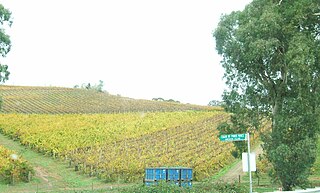
Mount Torrens is a town in the eastern Adelaide Hills region of South Australia, 46 kilometres east-north-east of the state capital, Adelaide and 8 km east of Lobethal. It is located in the Adelaide Hills Council and the Mid Murray Council local government areas. At the 2006 census, Mount Torrens had a population of 337.

The Little Para River is a seasonal creek running across the Adelaide Plains in the Australian state of South Australia, whose catchment fills reservoirs that supply some of the water needs of Adelaide’s northern suburbs.
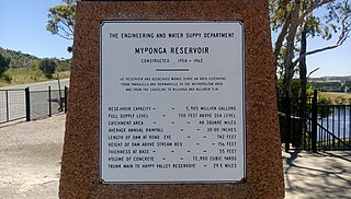
The Myponga Reservoir is a reservoir in South Australia, located about 60 km south of Adelaide near the town of Myponga. The reservoir is fed by the Myponga River and other rivers in the Myponga catchment. It provides about 5% of the City of Adelaide's water supply and is the main source of filtered water for southern metropolitan Adelaide and the southern coast area. Plans to use the Myponga River catchment as a major storage area were made in 1945. Construction began in 1958 and was completed in 1962, flooding what was from 1840 known as "Lovely Valley". Prior to the construction of the Myponga Water Treatment Plant in 1993, water from Myponga was used to supplement that of Happy Valley Reservoir.

Kangaroo Creek Reservoir is a 19,160 megalitre artificial water storage reservoir in the Adelaide Hills, South Australia. It was built from 1966 to 1969, by damming the River Torrens west of Cudlee Creek. The stored water is used to maintain the Hope Valley Reservoir's level via discharge through the Torrens. Water is held back by a 131 metres (430 ft) long, 65 m (213 ft) high concrete clad, rock filled dam wall.
As Australia's supply of freshwater is increasingly vulnerable to droughts, possibly as a result of climate change, there is an emphasis on water conservation and various regions have imposed restrictions on the use of water.
Millbrook is a locality in the Adelaide Hills, outside Adelaide, South Australia.
The Hope Valley Reservoir is a 2.84-gigalitre service reservoir in Hope Valley, South Australia, a suburb of Adelaide, South Australia.

Little Para Reservoir is a reservoir in South Australia serving the city of Adelaide. It was built between 1974 and 1977, costing A$11.5 million, and commissioned in January 1979.
The Tod Reservoir is located on the Eyre Peninsula in South Australia, in the localities of Whites Flat and Koppio, 27 km north of Port Lincoln. It is situated on the Tod River, the only stream on Eyre Peninsula, South Australia providing reliable flows; the reservoir is supplied by concrete channels fed from weirs constructed across the Tod River and its major tributary, Pillaworta Creek. The river was named after Robert Tod who discovered it during explorations in 1839. The Tod River flows into Louth Bay in Spencer Gulf. The reservoir is listed on the South Australian Heritage Register.
The Hundred of Para Wirra is a cadastral hundred of the County of Adelaide, South Australia, spanning a portion of the Adelaide Hills north of the Torrens Valley including Mount Crawford.

