Hydroelectricity, or hydroelectric power, is electricity generated from hydropower. Hydropower supplies one sixth of the world's electricity, almost 4,500 TWh in 2020, which is more than all other renewable sources combined and also more than nuclear power. Hydropower can provide large amounts of low-carbon electricity on demand, making it a key element for creating secure and clean electricity supply systems. A hydroelectric power station that has a dam and reservoir is a flexible source, since the amount of electricity produced can be increased or decreased in seconds or minutes in response to varying electricity demand. Once a hydroelectric complex is constructed, it produces no direct waste, and almost always emits considerably less greenhouse gas than fossil fuel-powered energy plants. However, when constructed in lowland rainforest areas, where part of the forest is inundated, substantial amounts of greenhouse gases may be emitted.

Lake Gordon is a man-made reservoir created by the Gordon Dam, located on the upper reaches of the Gordon River in the south-west region of Tasmania, Australia.

The Eildon Dam is a rock and earth-fill embankment dam with a controlled spillway across the Goulburn River, is located between the regional towns of Mansfield and Eildon within Lake Eildon National Park, in the Alpine region of Victoria, Australia. The dam's purpose is for the supply of potable water, irrigation, and the generation of hydroelectricity. The impounded reservoir is called Lake Eildon.The first cut of ground was done by Mr Bain and Mr MacLean from Scotland.

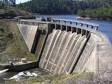
The Happy Valley Reservoir is a water reservoir located in the southern Adelaide suburb of Happy Valley, South Australia. Constructed when the total population of Adelaide numbered 315,200, the Happy Valley Reservoir now supplies over half a million people, from Adelaide's southern extent to the city centre. The surrounding area is home to much wildlife, including many kangaroos.
Happy Valley is a metropolitan suburb of Adelaide, South Australia. It is located 20 km south of the Central Business District of Adelaide.

The Onkaparinga River, known as Ngangkiparri or Ngangkiparingga in the Kaurna language, is a river located in the Southern Adelaide region in the Australian state of South Australia. Rising in the Mount Lofty Ranges, the river's estuary extends from Old Noarlunga to the river's mouth between the suburbs of Port Noarlunga and Port Noarlunga South.

South Para Reservoir is the second largest reservoir in South Australia, behind Mount Bold Reservoir, and the principal reservoir of the South Para River system. The reservoir's large capacity of around 45,330 megalitres and its location in the catchment area mean that it only ever fills completely once in every five years.

The Clarendon Weir is a weir in the Australian state of South Australia, located on the Onkaparinga River in the suburb of Clarendon, about 20 kilometres (12 mi) south of the Adelaide city centre.
Lostock Dam is a minor rockfill and clay core embankment dam with a concrete lined, flip bucket spillway across the Paterson River upstream of the village of East Gresford in the Hunter region of New South Wales, Australia. The dam's purpose includes flood mitigation, irrigation, water supply and conservation. Mini hydro-power facilities were retrofitted in 2010. The impounded reservoir is also called Lostock Dam.

The Wivenhoe Dam is a rock and earth-fill embankment dam with a concrete spillway across the Brisbane River in South East Queensland, Australia. The dam takes it names from the local Wivenhoe Pocket rural community. The dam wall is located about 80 kilometres (50 mi) by road from the centre of Brisbane. The primary purpose of the dam is the supply of potable water for the Brisbane and Ipswich regions. The dam also provides for flood mitigation control, hydroelectricity, and recreation. The impounded reservoir is called Lake Wivenhoe and the dam, the lake and a narrow strip of surrounding land forms a locality also called Lake Wivenhoe.
Cochrane Dam is a minor earthfill embankment dam with concrete spillway across Georges Creek, located in the South Coast region of New South Wales, Australia. The main purpose of the dam is to supply water for hydro-power at the downstream Brown Mountain Power Station and for irrigation purposes. The impounded reservoir is called Cochrane Lake.

The Burdekin Falls Dam, also known as the Burdekin Dam, is a concrete gravity dam with an uncontrolled spillway across the Burdekin River in the Whitsunday Region, Queensland, Australia. Built for the purpose of irrigation, the reservoir is called Lake Dalrymple, and is on the boundary of the Whitsunday Region and the Charters Towers Region. Burdekin Falls Dam is managed by SunWater. Water from the reservoir is also used to replenish downstream aquifers.
SA Water is a government business enterprise wholly owned by the Government of South Australia. It is a successor to the Engineering and Water Supply Department, styled E & W S, a state government department, and itself preceded by the Waterworks and Drainage Commission.
The Ross River Dam is a rock and earthfill-filled embankment dam across the Ross River, located between Kelso and Mount Stuart in the City of Townsville in northern Queensland, Australia. Built initially for flood control, Lake Ross, the impoundment created by the dam, serves as one of the major potable water supplies for the region.

Chichester Dam is a minor concrete gravity dam across the Chichester and Wangat rivers, upstream of Dungog, in the Hunter Region of New South Wales, Australia. The dam's main purpose is water supply for the Lower Hunter region. A mini hydro-electric power station operates at times of peak flow and is connected to the national grid. The impounded reservoir is Lake Chichester.
Kidston Dam also known as Copperfield Dam is a dam in Lyndhurst, Shire of Etheridge, Queensland, Australia. It is approximately 200 kilometres (120 mi) north of Hughenden and was built for the Kidston Gold Mine. The mine closed July 2001. The lake created by the dam has a capacity of 20,600 megalitres.
As Australia's supply of freshwater is increasingly vulnerable to droughts, possibly as a result of climate change, there is an emphasis on water conservation and various regions have imposed restrictions on the use of water.

The Adelaide Desalination plant (ADP), formerly known as the Port Stanvac Desalination Plant, is a sea water reverse osmosis desalination plant located in Lonsdale, South Australia which has the capacity to provide the city of Adelaide with up to 50% of its drinking water needs.
Hindmarsh Valley Reservoir is a reservoir in the Australian state of South Australia located in the gazetted locality of Hindmarsh Valley about 11 kilometres (7 mi) north of the municipal seat in Victor Harbor.