Miller Mountain (Park County, Montana)

Last updated
Miller Mountain
Daisy Pass - Gallatin National Forest (3762835307).jpg
North aspect, summit to right
Highest point
Elevation 10,494 ft (3,199 m) [1]
Prominence 777 ft (237 m) [1]
Parent peak Sheep Mountain [2]
Isolation 1.64 mi (2.64 km) [2]
Coordinates 45°02′48″N109°58′37″W / 45.0466707°N 109.9769218°W / 45.0466707; -109.9769218 [3]
Naming
Etymology Adam "Horn" Miller
Geography
USA Montana relief location map.jpg
Red triangle with thick white border.svg
Miller Mountain
Location in Montana
Usa edcp relief location map.png
Red triangle with thick white border.svg
Miller Mountain
Miller Mountain (the United States)
CountryUnited States
State Montana
County Park
Parent range Beartooth Mountains
Rocky Mountains
Topo map USGS Cooke City
Geology
Type of rock gabbro, breccia, monzonite

Miller Mountain is a 10,494-foot (3,199-metre) summit in Park County, Montana, United States.

Contents

Description

Miller Mountain is located 2.85 miles (4.59 km) northwest of Cooke City, Montana, in the Beartooth Mountains which are a subrange of the Rocky Mountains. [1] It is set within the New World Mining District and the Custer-Gallatin National Forest. [2] Precipitation runoff from the mountain's north slope drains into headwaters of the Stillwater River, whereas the south slope drains into Sheep Creek → Soda Butte CreekLamar River. Topographic relief is significant as the summit rises 2,000 feet (610 meters) above Sheep Creek in one mile (1.6 km). The mountain is composed of gabbro, Miocene breccia, and Eocene monzonite porphyry. [4] The mountain's toponym has been officially adopted by the United States Board on Geographic Names, [3] and has been featured in publications since at least 1911. [5] The mountain is named after Adam "Horn" Miller (1839–1913), who was one of the four trappers who discovered and named the New World Mining District in 1869, with the others being Bart Henderson, J. H. Moore, and James Gourley. [6] [7] Adam Miller staked a claim that he called Shoo Fly Mine at the 9,300-foot-elevation level on the south slope of this mountain which would bear his name. [6] [8] From 1878 through the late 1880s, the Shoo Fly produced gold, copper, and lead-silver ore, but it closed in 1893 to never reopen. [8] (Henderson Mountain is 1.61 miles (2.59 km) east-northeast of Miller Mountain). [1]

Climate

Based on the Köppen climate classification, Miller Mountain is located in a subarctic climate zone characterized by long, usually very cold winters, and mild summers. [9] Winter temperatures can drop below 0 °F with wind chill factors below −10 °F.

See also

Related Research Articles

<span class="mw-page-title-main">Elk Mountain (Flathead County, Montana)</span> Mountain in the American state of Montana

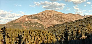
Elk Mountain is a 7,835-foot-elevation (2,388-meter) mountain summit located in Flathead County in the U.S. state of Montana. It is situated in the southern tip of Glacier National Park, in the Lewis Range, about four miles to the west side of the Continental Divide. US Highway 2 and the Hi-Line Subdivision of the BNSF Railway traverse the southern base of this mountain, approximately four miles west of Marias Pass. Topographic relief is significant as the northwest aspect rises 3,400 feet above Ole Creek in one mile. The nearest higher neighbor is Sheep Mountain 2.7 miles to the north-northwest. The mountain's name first appeared on a 1914 USGS map, and was officially adopted in 1929 by the United States Board on Geographic Names. The summit is the site of a former fire lookout that was built in the 1930s, and removed in 1963.

<span class="mw-page-title-main">Sheep Mountain (Beaverhead County, Montana)</span> Mountain in the state of Montana

Sheep Mountain is a 9,688-foot elevation (2,953 m) mountain summit in Beaverhead County, Montana, United States.

<span class="mw-page-title-main">Rock Peak</span> Mountain summit in Sanders County, Montana

Rock Peak is a 7,583-foot-elevation (2,311-meter) mountain summit in Sanders County, Montana.

<span class="mw-page-title-main">Engle Peak</span> Mountain in Montana, United States

Engle Peak is a 7,583-foot-elevation (2,311-meter) mountain summit in Sanders County, Montana.

<span class="mw-page-title-main">Elephant Peak</span> Mountain in Montana, United States

Elephant Peak is a 7,938-foot-elevation (2,420-meter) mountain summit located on the border shared by Lincoln and Sanders counties in Montana.

<span class="mw-page-title-main">Flat Top Mountain (Montana)</span> Mountain in Montana, United States

Flat Top Mountain is a 7,608-foot-elevation (2,319-meter) mountain summit located along the border shared by Lincoln and Sanders counties in Montana.

<span class="mw-page-title-main">Ojibway Peak</span> Mountain in Montana, United States

Ojibway Peak is a 7,303-foot-elevation (2,226-meter) mountain summit located on the border shared by Lincoln and Sanders counties in Montana.

<span class="mw-page-title-main">Boat Mountain</span> Mountain in Montana, United States

Boat Mountain is a 9,071-foot (2,765-metre) mountain summit in Gallatin County, Montana, United States.

<span class="mw-page-title-main">Hardscrabble Peak</span> Mountain in Montana, United States

Hardscrabble Peak is a 9,571-foot-elevation (2,917-meter) mountain summit in Gallatin County, Montana, United States.

<span class="mw-page-title-main">Pomp Peak</span> Mountain in Montana, United States

Pomp Peak is a 9,576-foot-elevation (2,919-meter) mountain summit in Gallatin County, Montana, United States.

<span class="mw-page-title-main">Sheep Mountain (Park County, Montana)</span> Mountain in Montana, United States

Sheep Mountain is a 10,552-foot (3,216-metre) mountain summit in Park County, Montana, United States.

<span class="mw-page-title-main">Big Horn Peak</span> Mountain in Montana, United States

Big Horn Peak is a 9,935-foot (3,028-metre) mountain summit in Gallatin County, Montana, United States.

<span class="mw-page-title-main">Ramshorn Peak (Montana)</span> Mountain in Montana, United States

Ramshorn Peak is a 10,296-foot (3,138-metre) mountain summit in Gallatin County, Montana, United States.

<span class="mw-page-title-main">Steamboat Mountain (Gallatin County, Montana)</span> Mountain in Montana, United States

Steamboat Mountain is a 10,030-foot (3,057-metre) mountain summit in Gallatin County, Montana, United States.

<span class="mw-page-title-main">Sheep Mountain (Gallatin Range, Montana)</span> Mountain in Montana, United States

Sheep Mountain is a 10,097-foot (3,078-metre) mountain summit in Park County, Montana, United States.

<span class="mw-page-title-main">Fisher Mountain</span> Mountain in Montana, United States

Fisher Mountain is a 10,246-foot (3,123-metre) summit in Park County, Montana, United States.

<span class="mw-page-title-main">Scotch Bonnet Mountain</span> Mountain in Montana, United States

Scotch Bonnet Mountain is a 10,385-foot (3,165-metre) summit in Park County, Montana, United States.

<span class="mw-page-title-main">Sheep Mountain (Beartooth Mountains)</span> Mountain in Montana, United States

Sheep Mountain is a 10,608-foot (3,233-metre) summit in Park County, Montana, United States.

<span class="mw-page-title-main">Henderson Mountain</span> Mountain in Montana, United States

Henderson Mountain is a 10,343-foot (3,153-metre) summit in Park County, Montana, United States.

<span class="mw-page-title-main">Crown Butte</span> Mountain in Montana, United States

Crown Butte is a 10,225-foot (3,117-metre) summit in Park County, Montana, United States.

References

  1. 1 2 3 4 "Miller Mountain, Montana". Peakbagger.com. Retrieved 2024-08-04.
  2. 1 2 3 "Miller Mountain - 10,500' MT". listsofjohn.com. Retrieved 2024-08-04.
  3. 1 2 "Miller Mountain". Geographic Names Information System . United States Geological Survey, United States Department of the Interior . Retrieved 2024-08-04.
  4. Contributions to Economic Geology, G. F. Loughlin, 1930, USGS Bulletin 811, US Government Printing Office, p. 35–36.
  5. Mineral Resources of the United States, USGS, US Government Printing Office, 1911, p. 492.
  6. 1 2 Black Diamonds from the Treasure State, Robert A. Schalla, Indiana University Press, 2024, ISBN   9780253068200
  7. Grants Mining Districts of the Western United States: Volume 2, Jerry Grant, Xlibris Corporation, 2020, ISBN   9781664149021
  8. 1 2 The New World Mining District, The Historical Marker Database, Retrieved 2024-08-04.
  9. Peel, M. C.; Finlayson, B. L.; McMahon, T. A. (2007). "Updated world map of the Köppen−Geiger climate classification". Hydrol. Earth Syst. Sci. 11 (5): 1633–1644. Bibcode:2007HESS...11.1633P. doi: 10.5194/hess-11-1633-2007 . ISSN   1027-5606. S2CID   9654551.