
Yakutsk is the capital city of the Sakha Republic, Russia, located about 450 kilometers (280 mi) south of the Arctic Circle.

The Yakuts or the Sakha are a Turkic ethnic group who mainly live in the Republic of Sakha in the Russian Federation, with some extending to the Amur, Magadan, Sakhalin regions, and the Taymyr and Evenk Autonomous Districts. The Yakut language belongs to the Siberian branch of the Turkic languages.
State Assembly is the name for the unicameral legislature of the Sakha Republic, Russia. It is a legal successor of the Supreme Council of the Sakha Republic.
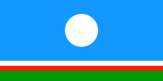
The flag of the Sakha Republic, in the Russian Federation, is one of the official symbols of the Sakha Republic, alongside the coat of arms and the national anthem of the Sakha Republic. The flag has four horizontal stripes. From top to bottom, the stripes are light blue, white (1/16), red (1/16), and green (1/8). The flag has been used officially as the flag of the Sakha Republic since 14 October 1992. The light blue stripe is charged with a white disc in the center. The diameter of the disc is 2/5 of the flag's width.

Ust-Yansky District is an administrative and municipal district, one of the thirty-four in the Sakha Republic, Russia. It is located in the north of the republic in the Yana River delta on the coast of the Laptev Sea and borders with Allaikhovsky and Abyysky Districts in the east, Momsky District in the south, Verkhoyansky District in the southwest, and with Bulunsky District in the west. The area of the district is 120,300 square kilometers (46,400 sq mi). Its administrative center is the urban locality of Deputatsky. Population: 8,056 (2010 Census); 10,009 ; 41,265 (1989 Census). The population of Deputatsky accounts for 37.0% of the district's total population.

Aldansky District is an administrative and municipal district, one of the thirty-four in the Sakha Republic, Russia. It is located in the south of the republic on the right bank of the Lena River near the mouth of the Aldan River and borders with Khangalassky and Amginsky Districts in the north, Ust-Maysky District in the northeast, Khabarovsk Krai in the east, Neryungrinsky District in the south, and with Olyokminsky District in the west and southwest. The area of the district is 156,800 square kilometers (60,500 sq mi). Its area is larger than the country of Bangladesh. Its administrative center is the town of Aldan. As of the 2010 Census, the total population of the district was 42,632, with the population of Aldan accounting for 49.9% of that number.
Eveno-Bytantaysky National District is an administrative and municipal district, one of the thirty-four in the Sakha Republic, Russia. The area of the district is 52,300 square kilometers (20,200 sq mi). Its administrative center is the rural locality of Batagay-Alyta. As of the 2010 Census, the total population of the district was 2,867, with the population of Batagay-Alyta accounting for 63.9% of that number.

Gorny District is an administrative and municipal district, one of the thirty-four in the Sakha Republic, Russia. It is located in the center of the republic and borders Vilyuysky and Kobyaysky Districts in the north, Namsky District and the territory of the city of republic significance of Yakutsk in the east, Khangalassky District in the south, Olyokminsky District in the southwest, and Verkhnevilyuysky District in the west. The area of the district is 45,600 square kilometers (17,600 sq mi). Its administrative center is the rural locality of Berdigestyakh. As of the 2010 Census, the total population of the district was 11,706, with the population of Berdigestyakh accounting for 55.2% of that number.
Khangalassky District is an administrative and municipal district, one of the thirty-four in the Sakha Republic, Russia. It is located in the center of the republic and borders Megino-Kangalassky District in the east, Amginsky and Aldansky Districts in the south, Olyokminsky District in the southwest, Gorny District in the northwest, and the territory of the city of republic significance of Yakutsk in the north. The area of the district is 24,700 square kilometers (9,500 sq mi). Its administrative center is the town of Pokrovsk. As of the 2010 Census, the total population of the district, excluding its administrative center, was 24,557.

Megino-Kangalassky District is an administrative and municipal district, one of the thirty-four in the Sakha Republic, Russia. It is located in the central part of the republic, on the Lena River opposite Yakutsk, the capital of the republic. It borders Ust-Aldansky District in the north, Churapchinsky District in the east, Amginsky District in the southeast, Khangalassky District in the southwest, and is bounded by the Lena River in the west. The area of the district is 11,700 square kilometers (4,500 sq mi). Its administrative center is the rural locality of Mayya. As of the 2010 Census, the total population of the district was 31,278, with the population of Mayya accounting for 23,.3% of that number.

Namsky District is an administrative and municipal district, one of the thirty-four in the Sakha Republic, Russia. The district is located in the center of the republic and borders Ust-Aldansky District in the east, Megino-Kangalassky District in the southeast, the territory of the city of republic significance of Yakutsk in the south, Gorny District in the west, and Kobyaysky District in the north. The area of the district is 11,900 square kilometers (4,600 sq mi). Its administrative center is the rural locality of Namtsy. As of the 2010 Census, the total population of the district was 23,198, with the population of Namtsy accounting for 38.3% of that number.

Verkhnevilyuysky District is an administrative and municipal district, one of the thirty-four in the Sakha Republic, Russia. It is located in the western central part of the republic and borders with Vilyuysky District in the east, Gorny District in the southeast, Olyokminsky District in the south, Suntarsky and Nyurbinsky Districts in the west, and with Olenyoksky District in the northwest. The area of the district is 42,000 square kilometers (16,000 sq mi). Its administrative center is the rural locality of Verkhnevilyuysk. Population: 21,661 (2010 Census); 21,383 ; 20,626 (1989 Census). The population of Verkhnevilyuysk accounts for 29.8% of the district's total population.

Zhigansky District is an administrative and municipal district, one of the thirty-four in the Sakha Republic, Russia. It is located in the northern central part of the republic and borders with Bulunsky District in the north, Eveno-Bytantaysky National District in the east, Kobyaysky District in the southeast, Vilyuysky District in the southwest, and with Olenyoksky District in the northwest. The area of the district is 140,200 square kilometers (54,100 sq mi). Its administrative center is the rural locality of Zhigansk. Population: 4,296 (2010 Census); 4,312 ; 5,678 (1989 Census). The population of Zhigansk accounts for 79.6% of the district's total population.

Oymyakonsky District is an administrative and municipal district, one of the thirty-four in the Sakha Republic, Russia. It is located in the east of the republic and borders with Ust-Maysky District in the southwest, Tomponsky District in the west, Momsky District in the north, Magadan Oblast in the east, and with Khabarovsk Krai in the south. The area of the district is 92,300 square kilometers (35,600 sq mi). Its administrative center is the urban locality of Ust-Nera. Population: 10,109 (2010 Census); 14,670 ; 31,078 (1989 Census). The population of Ust-Nera accounts for 63.9% of the district's total population.

Ust-Maysky District is an administrative and municipal district, one of the thirty-four in the Sakha Republic, Russia. It is located in the east of the republic and borders with Oymyakonsky District in the northeast, Khabarovsk Krai in the east and south, Aldansky District in the southwest, Amginsky District in the west, Churapchinsky and Tattinsky Districts in the northwest, and with Tomponsky District in the north. The area of the district is 95,300 square kilometers (36,800 sq mi). Its administrative center is the urban locality of Ust-Maya. Population: 8,629 (2010 Census); 11,568 ; 20,337 (1989 Census). The population of Ust-Maya accounts for 33.9% of the district's total population.

Neryungrinsky District is an administrative and municipal district, one of the thirty-four in the Sakha Republic, Russia. It is the southernmost district of Sakha and borders Aldansky District in the north, Olyokminsky District in the west and northwest, Amur Oblast and a small area of Zabaykalsky Krai in the south, and Khabarovsk Krai in the east. The area of the district is 98,900 square kilometers (38,200 sq mi). Its administrative center is the town of Neryungri. Population : 21,019 (2010 Census).

The State Anthem of the Sakha Republic or National Anthem of Yakutia is the regional anthem of the Sakha Republic, a federal subject of Russia. The national anthem is one of the official symbols of the Sakha Republic, alongside with the flag and the coat of arms of the Sakha Republic. It was originally written in the Sakha language by Savva Tarasov and Mikhail Timofeyev. The anthem was translated into Russian by Vladimir Fedorov. The music was composed by Kirill Gerasimov. The anthem was officially adopted on 15 July 2004.

Zarechny is a rural locality, the only inhabited locality, and the administrative center of Zarechny Village of Olyokminsky District in the Sakha Republic, Russia, located 3 kilometers (1.9 mi) from Olyokminsk, the administrative center of the district. Its population as of the 2010 Census was 620, of whom 327 were male and 293 female, down from 674 as recorded during the 2002 Census.
Yllymakh is a rural locality, one of five settlements, in addition to Tommot, the administrative centre of the settlement, the Urban-type settlement of Bezymyanny, and the villages of Ulu and Verkhnyaya Amga in the Town of Tommot of Aldansky District in the Sakha Republic, Russia. It is located 150 kilometers (93 mi) from Aldan, the district centre and 75 kilometers (47 mi) from Tommot. Its population as of the 2010 Census was 472; down from 500 recorded in the 2002 Census.


