Minsk region | |
---|---|
From the top to bottom-right: Nesvizh Castle, Church of the Assumption of the Blessed Virgin Mary in Budslaw, Church of the Resurrection of Christ in Barysaw, Kapyl, Maladzyechna | |
![]() | |
Country | Belarus |
Administrative center | Minsk |
Largest cities | Barysaw - 150,400 Salihorsk - 101,400 Maladzyechna - 98,514 |
Districts | 22 (and 1 subordinate city) Cities - 22 Urban localities - 20 |
City districts | 8 |
Government | |
• Chairman | Aleksandr Turchin |
Area | |
• Total | 39,912.35 km2 (15,410.24 sq mi) |
Highest elevation | 345 m (1,132 ft) |
Population (2024) | |
• Total | 1,460,289 |
• Density | 37/km2 (95/sq mi) |
GDP | |
• Total | Br 41.0 billion (€11.5 billion) |
• Per capita | Br 28,000 (€7,900) |
Area code | +375 17 |
ISO 3166 code | BY-MI |
HDI (2022) | 0.811 [2] very high · 1st |
Website | www |
![]() |
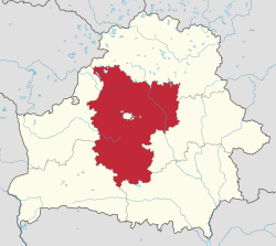
Minsk region, also known as Minsk oblast [a] or Minsk voblasts, [b] is one of the six regions of Belarus. Its administrative center is Minsk, although it is a separate administrative territorial entity of Belarus. The region's population was recorded at 1,411,500 in 2011. [3]
Minsk region covers a total area of 39,900 square kilometres (15,400 sq mi), [3] about 19.44% of the total area of the entire country. Lake Narach, the largest lake in the country, is located in the northern part of the region. There are four other large lakes in this region: Svir (8th largest), Myadel (11th largest), Syalyava (14th largest) and Myastro (15th largest). [4] It is the only region of Belarus whose border is not part of the international border of Belarus.
Beginning the 10th century, the territory of the current Minsk region was part of Kievan Rus', the Principality of Polotsk, and later it was included in the Grand Duchy of Lithuania. With the unification of the Grand Duchy of Lithuania and the Kingdom of Poland, the territory became part of the Polish–Lithuanian Commonwealth.
In 1793, as a result of the Second Partition of Poland, the area was annexed by Russia as the Minsk region. During the collapse of the Russian Empire due to the Civil War, the western part was annexed to Poland in 1921, while the east became Soviet Belarus. The Polish National District with its capital in Dzyarzhynsk was located in the Soviet-controlled part of the current oblast in the interwar period.
The Minsk region was established on 15 January 1938, based on the amendment of the Constitutional Law of the USSR. As of 20 February 1938, the area included 20 districts. Following the Soviet invasion of Poland on September 17, 1939 at the start of World War II, the former eastern lands of the Second Polish Republic were annexed in accordance with the Molotov–Ribbentrop Pact partitioning Poland and added to the Minsk region.
On 20 September 1944, by the decree of the Presidium of the Supreme Soviet of the USSR, the Gressky, Kopyl, Krasnoslobodski, Luban, Slutsky, Starobin, Starodorozhski districts and the city of Sluck were removed from the Minsk region and transferred to the newly formed Bobruisk region.
On 8 January 1954, by the decree of the USSR Presidium of the Supreme Soviet, the Nesvizhski and Stolbtsovsky districts from the abolished Baranovichi region, as well as the Glusk, Gressky, Kopyl, Krasnoslobodski, Luban, Slutsky, Starobin, Starodorozhski districts and the city of Sluck from the abolished Bobruisk region, were added to the Minsk region.
In 1960, following the abolition of Molodechno region, its southern part became the northern part of the Minsk region.
The number of travel agencies in Minsk region grew from twelve in 2000 to seventy in 2010. [5] [6] The most popular tourist destinations of the region are Zaslavskoye Lake, the Zhdanovichi area which has health resorts, Nesvizh Palace and its surroundings, as well as the alpine ski resorts of Logoysk and Silichi.
The Minsk region comprises 22 districts (raions), 307 selsovets, 22 cities, 8 city municipalities, and 20 urban-type settlements.
Population of cities and towns in Minsk region according to 2023 estimates: [7]
English | Belarusian | Russian | Pop. (2023) |
---|---|---|---|
Barysaw | Барысаў | Борисов | 136,409 |
Salihorsk | Салігорск | Солигорск | 98,590 |
Maladzyechna | Маладзечна | Молодечно | 89,268 |
Zhodzina | Жодзiна | Жодино | 64,000 |
Slutsk | Слуцк | Слуцк | 60,376 |
Dzyarzhynsk | Дзяржынск | Дзержинск | 29,811 |
Vilyeyka | Вілейка | Вилейка | 26,811 |
Smalyavichy | Смалявічы | Смолевичи | 21,820 |
Maryina Horka | Мар'іна Горка | Марьина Горка | 20,242 |
Fanipal | Фаніпаль | Фаниполь | 17,768 |
Stowbtsy | Стоўбцы | Столбцы | 17,640 |
Zaslawye | Заслаўе | Заславль | 17,419 |
Nyasvizh | Нясвіж | Несвиж | 15,907 |
Lahoysk | Лагойск | Логойск | 15,515 |
Byerazino | Беразіно | Березино | 11,395 |
Lyuban | Любань | Любань | 11,360 |
Kletsk | Клецк | Клецк | 11,350 |
Staryya Darohi | Старыя Дарогі | Старые Дороги | 10,972 |
Uzda | Узда | Узда | 10,677 |
Chervyen | Чэрвень | Червень | 10,542 |
Kapyl | Капыль | Копыль | 10,087 |
Valozhyn | Валожын | Воложин | 10,064 |
Krupki | Крупкі | Крупки | 8,487 |
Myadzyel | Мядзел | Мядель | 6,999 |
The lands of Belarus during the Middle Ages became part of Kievan Rus' and were split between different regional principalities, including Polotsk, Turov, Vitebsk, and others. Following the Mongol invasions of the 13th century, these lands were absorbed by the Grand Duchy of Lithuania, which later was merged into the Polish–Lithuanian Commonwealth in the 16th century.
The Byelorussian Soviet Socialist Republic, also known as Soviet Byelorussia or simply Byelorussia, was a republic of the Soviet Union (USSR). It existed between 1920 and 1922 as an independent state, and afterwards as one of fifteen constituent republics of the USSR from 1922 to 1991, with its own legislation from 1990 to 1991. The republic was ruled by the Communist Party of Byelorussia. It was also known as the White Russian Soviet Socialist Republic.
Brest region, also known as Brest oblast, Brest voblasts or Brestchyna, is one of the six regions of Belarus. Its administrative center is Brest. Other major cities in the region include Baranavichy, and Pinsk. As of 2024, it has a population of 1,308,569.
Grodno region, also known as Grodno oblast or Hrodna voblasts, is one of the regions of Belarus. Its administrative center, Grodno, is the largest city in the region. As of 2024, it has a population of 992,556.
Gomel region, also known as Gomel oblast or Homyel voblasts, is one of the regions of Belarus. Its administrative center is Gomel. The total area of the region is 40,400 square kilometres (15,600 sq mi). As of 2024, it has a population of 1,338,617.
Vitebsk region, also known as Vitebsk oblast or Vitsyebsk voblasts, is one of the regions of Belarus. Its administrative center is Vitebsk. It is located in the north of the country, and borders on Russia.
Mogilev region, also known as Mogilev oblast or Mahilyow voblasts, is one of the regions of Belarus. Its administrative center is the city of Mogilev.
Ternopil Oblast, also referred to as Ternopilshchyna or Ternopillia, is an oblast (province) of Ukraine. Its administrative center is Ternopil, through which flows the Seret, a tributary of the Dniester. Population: 1,021,713.
Latgale, also known as Latgalia or Latgallia, is one of the Historical Latvian Lands. It is the easternmost region of the country and lies north of the Daugava River. While most of Latvia is historically Lutheran, Latgale is predominantly Roman Catholic: 65.3% according to a 2011 survey. After the Counter-Reformation it was the northernmost predominantly Catholic province or region in Europe. There is a considerable Eastern Orthodox minority (23.8%), of which 13.8% are Russian Orthodox Christians and 10.0% are Old Believers. As of 2020, the region's population was 255,968.
Slutsk is a town in Minsk Region, Belarus. It serves as the administrative center of Slutsk District, and is located on the Sluch River 105 km (65 mi) south of the capital Minsk. As of 2024, it has a population of 60,056.
Nyasvizh or Nesvizh is a town in Minsk Region, Belarus. It serves as the administrative centre of Nyasvizh District. Nyasvizh is the site of Nesvizh Castle, a World Heritage Site. In 2009, its population was 14,300. As of 2024, it has a population of 15,968.
Western Belorussia or Western Belarus is a historical region of modern-day Belarus which belonged to the Second Polish Republic during the interwar period. For twenty years before the 1939 invasion of Poland, it was the northern part of the Polish Kresy macroregion. Following the end of World War II in Europe, most of Western Belorussia was ceded to the Soviet Union by the Allies, while some of it, including Białystok, was given to the Polish People's Republic. Until the dissolution of the Soviet Union in 1991, Western Belorussia formed the western part of the Byelorussian Soviet Socialist Republic (BSSR). Today, it constitutes the west of modern Belarus.
The Byelorussian Military District was a military district of the Soviet Armed Forces. Originally formed just before World War I as the Minsk Military District out of the remnants of the Vilno Military District and the Warsaw Military District, it was headed by the Russian General Eugen Alexander Ernst Rausch von Traubenberg.
Belarus is a landlocked, generally flat country without natural borders, that occupies an area of 207,600 square kilometers (80,200 sq mi). Its neighbors are Russia to the east and northeast, Latvia to the north, Lithuania to the northwest, Poland to the west, and Ukraine to the south. Its extension from north to south is 560 km (350 mi), from west to east is 650 km (400 mi).
The Holocaust in Belarus refers to the systematic extermination of Jews living in the Byelorussian Soviet Socialist Republic during its occupation by Nazi Germany in World War II. It is estimated that roughly 800,000 Belarusian Jews were murdered during the Holocaust. However, other estimates place the number of Jews killed between 500,000 and 550,000.
Krupki is a town in Minsk Region, Belarus. It serves as the administrative center of Krupki District.
Kapyl is a town in Minsk Region, Belarus. It serves as the administrative center of Kapyl District. It is located 34 kilometers (21 mi) west-northwest of Slutsk and 90 kilometers (56 mi) south-southwest of the capital Minsk. In 2009, its estimated population was 9,900 based on the provisional figures from the 2009 census. As of 2024, it has a population of 9,985.
Vitebsk Governorate was an administrative-territorial unit (guberniya) of the Russian Empire, with the seat of governorship in Vitebsk. It was established in 1802 by splitting Belarusian Governorate and existed until 1924. Today most of the area belongs to Belarus, the northwestern part to Latvia and the northeastern part to Pskov and Smolensk Oblasts of Russia.Together with the Vilna, Kovno, Grodno, Minsk, and Mogilev Governorates, it formed the Northwestern Krai. The provincial city was Vitebsk, the largest city was Dvinsk.
The Principality of Slutsk was originally a specific Turov Principality of land in the 12th through 14th centuries. It stood out in 1160 and took shape in the 1190s. It became a large feudal principality in the Grand Duchy of Lithuania.
Nyeharelaye or Negoreloe is an agrotown in Dzyarzhynsk District, Minsk Region, Belarus. Until 2009, it had the status of urban-type settlement.