Mississippi Highway 198

Last updated

Ellipse sign 198.svg
Mississippi Highway 198
Various sections of MS 198 highlighted in red
Route information
Maintained by MDOT
Length24.937 mi [1]  (40.132 km)
6 sections
Existed1993–present
Highway system
Ellipse sign 184.svg MS 184 I-220.svg I-220

Mississippi Highway 198 (MS 198) is a state highway in the U.S. state of Mississippi. The highway is the designation for six former segments of U.S. Highway 98 (US 98) that have been bypassed by newer alignments. These six segments are located in Tylertown, Columbia, Hattiesburg, Beaumont, McLain, and Lucedale. Five of the six sections of MS 198 are two-lane undivided roads that pass through small towns; the exception is the Hattiesburg section which is a four-lane divided highway running through developed areas of the city. The total length of the six sections of MS 198 is 24.937 miles (40.132 km).

Contents

What is now MS 198 originally existed as gravel and earth roads by the 1920s. The portions of the current road became parts of MS 24 and MS 15 in the 1930s and were all paved by the 1940s. US 98 was designated on these segments in 1955. Between the 1970s and 1990s, US 98 was rerouted to bypass Tylertown, Columbia, Hattiesburg, Beaumont, McLain, and Lucedale. By 1998, MS 198 was designated onto the former alignment of US 98 through these communities. The McLain section was truncated from US 98 east of town to MS 57 in 2005.

Route description

MS 198 is legally defined in Mississippi Code § 65-3-3 as the designation for former sections of US 98 that have been relocated by the completion of new alignments. [2]

Tylertown

Ellipse sign 198.svg

Mississippi Highway 198

Location Tylertown
Length5.2 mi [3]  (8.4 km)

The Tylertown section of MS 198 begins at an intersection with US 98 northwest of Tylertown in Walthall County, heading southeast on two-lane undivided Beluah Avenue. The road passes through wooded areas with some homes and businesses. After passing to the south of Walthall County General Hospital, MS 198 comes to an intersection with MS 48, at which point that highway begins a concurrency with MS 198. The two highways continue southeast into Tylertown, curving east into residential areas. The road heads into the commercial downtown and comes to an intersection with MS 27. The highway passes more businesses before leaving the downtown and heading into wooded areas with some homes. MS 48 splits from MS 198 by heading southeast, with MS 198 continuing east past residences and commercial establishments on Old Highway 98 East. The road leaves Tylertown and heads northeast through wooded areas with some homes. This section of MS 198 ends at another intersection with US 98. [3] [4]

Columbia

Ellipse sign 198.svg

Mississippi Highway 198

Location Columbia
Length4.2 mi [5]  (6.8 km)

The Columbia section of MS 198 begins at an intersection with US 98 southwest of Columbia in Marion County, heading northeast on two-lane undivided South High School Avenue. The road passes through woodland, curving north into Columbia. Here, the highway heads past several businesses before turning east onto Broad Street. MS 198 heads through residential areas before passing through wooded areas with some homes and businesses as Old Highway 98 East, ending at an intersection with US 98 east of Columbia. [4] [5]

Hattiesburg

Ellipse sign 198.svg

Mississippi Highway 198

Location Hattiesburg
Length1.4 mi [6]  (2.3 km)

The Hattiesburg section begins at an interchange with Interstate 59 (I-59) and US 98 in Hattiesburg, Lamar County, where the road continues west as part of US 98. From this interchange, MS 198 heads east into Forrest County on Hardy Street, a four-lane divided highway that passes several businesses. The highway passes to the south of the University of Southern Mississippi before ending at an intersection with US 49. Past this intersection, Hardy Street continues east as a four-lane undivided city street. [4] [6]

Beaumont

Ellipse sign 198.svg

Mississippi Highway 198

Location Beaumont
Length4.5 mi [7]  (7.2 km)

The Beaumont section of MS 198 begins at an intersection with US 98 within the DeSoto National Forest northwest of Beaumont in Perry County, heading east on a two-lane undivided road. The highway heads through dense forests, curving southeast near a few homes as it runs a short distance to the southwest of Canadian National's Beaumont Subdivision railroad line. The road passes through more forests before entering Beaumont, where it heads near a mix of residences and businesses. MS 198 turns northeast to cross the railroad line and come to an intersection with MS 15. At this point, MS 198 turns southeast to form a concurrency with MS 15, leaving Beaumont for dense forests and running to the northeast of the Canadian National line. The road curves south and ends at an interchange with US 98 southeast of Beaumont. [4] [7]

McLain

Ellipse sign 198.svg

Mississippi Highway 198

Location McLain
Length1.8 mi [8]  (2.9 km)

The McLain section of MS 198 begins at an intersection with US 98 northwest of McLain in Greene County, heading southeast on two-lane undivided West Main Street. The road heads through wooded areas with some homes, entering McLain. The highway passes through residential and commercial areas in the town. MS 198 continues through woodland with some development a short distance to the northeast of Canadian National's Beaumont Subdivision railroad line, ending at an intersection with MS 57. [4] [8]

Lucedale

Ellipse sign 198.svg

Mississippi Highway 198

Location Lucedale
Length9.5 mi [9]  (15.3 km)

The Lucedale section of MS 198 begins at an intersection with US 98 northwest of Lucedale in George County, heading southeast on two-lane undivided Main Street. The road heads through dense forests with some homes, passing under Canadian National's Beaumont Subdivision railroad line. The highway continues through more rural areas, heading more to the east and passing under MS 63, at which point the railroad tracks run immediately to the north of the road. MS 198 curves southeast away from the tracks into more forests, eventually entering Lucedale. The road heads through wooded areas of homes before turning east and passing through the commercial downtown. In this area, the highway intersects the eastern terminus of MS 26 and the northern terminus of MS 613. The road leaves Lucedale, crossing the Canadian National line and heading into a mix of farmland and woodland with some development. This section of MS 198 ends at another intersection with US 98 east of Lucedale. [4] [9]

History

The current alignments of MS 198 existed by 1928 as unnumbered roads. The sections in Tylertown, Columbia, Hattiesburg, and Beaumont were gravel roads and the sections in McLain and Lucedale were unimproved roads. [10] By 1932, what is now MS 198 in Tylertown, Columbia, Hattiesburg, Beaumont, and McLain became a part of MS 24, which ran east-west across the southern part of the state. [11] The section of road in McLain became a gravel road by 1933. [12] In 1935, the road west of Tylertown became paved. [13] MS 15 was designated onto MS 24 east of Beaumont and in McLain and what is now the Lucedale portion of MS 198 in 1936. [14] A year later, the portion of road east of Lucedale was paved. [15] In 1938, the portion of current MS 198 southwest of Columbia was paved. [16] The road east of Tylertown was paved by 1939. [17] In 1940, a new alignment of MS 24 between McComb and Tylertown was under construction, which included what is now MS 198 northwest of Tylertown. Also by this time, the road between Columbia and MS 44 was paved. [18] In 1941, the portions of road in Hattiesburg, east of Beaumont, in McLain, and northwest of Lucedale were paved. [19] The road west of Beaumont was paved in 1943. [20] The portion of MS 24 between McComb and Tylertown was completed as a paved road in 1944. [21] In 1955, US 98 was extended into Mississippi, replacing the MS 24 and MS 15 designations on what is now MS 198. [22]

By 1973, the road bypassed Columbia. [23] In 1984, US 98 was routed to bypass Hattiesburg on I-59 and a new freeway. [24] A bypass to the north of Tylertown was built for US 98 in 1985. [25] US 98 was moved to a new alignment to bypass Lucedale in 1988. [26] In 1996, US 98 was routed out of Beaumont and McLain as a result of the construction of a new alignment on a divided highway. [27] By 1998, MS 198 was marked on the six former alignments of US 98 in Tylertown, Columbia, Hattiesburg, Beaumont, McLain, and Lucedale. [28] In 2005, the eastern terminus of the McLain section of MS 198 was truncated from US 98 to MS 57 due to the closing, and subsequent demolition, of a bridge across the Leaf River. [29]

Major intersections

Tylertown

The entire route is in Tylertown, Walthall County.

mi [3] kmDestinationsNotes
0.00.0US 98.svg US 98 Western terminus
1.52.4Elongated circle 48.svg MS 48 westWest end of MS 48 overlap
2.33.7Elongated circle 27.svg MS 27 (Franklinton Street)
3.15.0Elongated circle 48.svg MS 48 eastEast end of MS 48 overlap
5.28.4US 98.svg US 98 Eastern terminus
1.000 mi = 1.609 km; 1.000 km = 0.621 mi

Columbia

The entire route is in Columbia, Marion County.

mi [5] kmDestinationsNotes
0.00.0US 98.svg US 98  Tylertown, Foxworth, Hattiesburg Western terminus
4.26.8US 98.svg US 98  Tylertown, Foxworth, Hattiesburg Eastern terminus
1.000 mi = 1.609 km; 1.000 km = 0.621 mi

Hattiesburg

The entire route is in Hattiesburg.

Countymi [6] kmDestinationsNotes
Lamar 0.00.0I-59.svgUS 98.svg I-59  / US 98 (Hardy Street) Laurel, New Orleans, Mobile, Columbia I-59 exit 65, western terminus
Forrest 1.42.3US 49.svg US 49 Eastern terminus
1.000 mi = 1.609 km; 1.000 km = 0.621 mi

Beaumont

The entire route is in Beaumont, Perry County.

mi [7] kmDestinationsNotes
0.00.0US 98.svg US 98 Western terminus
2.74.3Ellipse sign 15.svg MS 15 northWest end of MS 15 overlap
4.26.8US 98.svgEllipse sign 15.svg US 98  / MS 15 Interchange, eastern terminus
1.000 mi = 1.609 km; 1.000 km = 0.621 mi

McLain

The entire route is in McLain, Greene County.

mi [8] kmDestinationsNotes
0.00.0US 98.svg US 98 Western terminus
1.82.9Elongated circle 57.svg MS 57 Eastern terminus
1.000 mi = 1.609 km; 1.000 km = 0.621 mi

Lucedale

The entire route is in Lucedale, George County.

mi [9] kmDestinationsNotes
0.00.0US 98.svg US 98 Western terminus
4.87.7Elongated circle 26.svg MS 26 west (Winter Street)Eastern terminus of MS 26
5.18.2Ellipse sign 613.svg MS 613 south (Mill Street)Northern terminus of MS 613
9.515.3US 98.svg US 98 Eastern terminus
1.000 mi = 1.609 km; 1.000 km = 0.621 mi

See also

Related Research Articles

U.S. Route 98 Highway in the United States

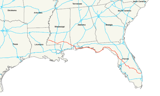
U.S. Route 98 is an east–west United States Highway in the Southeastern United States that runs from western Mississippi to southern Florida. It was established in 1933 as a route between Pensacola and Apalachicola, Florida, and has since been extended westward into Mississippi and eastward across the Florida Peninsula. It runs along much of the Gulf Coast between Mobile, Alabama, and Crystal River, Florida, including extensive sections closely following the coast between Mobile and St. Marks, Florida. The highway's western terminus is with US 84 in Meadville, Mississippi. Its eastern terminus is Palm Beach, Florida, at State Road A1A (SR A1A) near the Mar-a-Lago resort.

Mississippi Highway 172 (MS 172) is a state highway located in Tishomingo County, Mississippi. The route runs 12.074 mi (19.431 km) from U.S. Route 72 (US 72) near Burnsville east to US 72 near Oldham, just west of the Alabama border. The route is a two-lane undivided road its entire length and runs mostly through wooded areas. It also passes through the town of Iuka, where it has an intersection with MS 25.

Mississippi Highway 145 (MS 145) is the designation for the parts of the old U.S. Route 45 (US 45) roadbed that the state continues to maintain or has designated. Those ten sections travel through Waynesboro, near Boice, through Shubuta, from De Soto to Meridian, through Shuqualak, through Macon, through Aberdeen, through Nettleton, from Shannon to Booneville, and through Corinth.

Mississippi Highway 469 is a state highway in central Mississippi, located in Simpson and Rankin counties. The route starts at MS 28 near Georgetown, and it travels north through western Simpson County. The road enters the community of Harrisville and enters Rankin County soon after. It intersects U.S. Route 49 in Florence, and it ends at MS 468 near Whitfield. The route was designated in 1953, and it was extended southwards to MS 20 in 1956. By 1960, all of the route was paved with asphalt.

Mississippi Highway 35 is a state highway in Mississippi. It runs north–south for 274.7 miles (442.1 km), beginning at the Louisiana state line and ending at a junction with MS 315 at Sardis Dam. MS 35 serves the counties of Marion, Jefferson Davis, Covington, Smith, Scott, Leake, Attala, Carroll, Grenada, Tallahatchie, and Panola.

Mississippi Highway 63 is a state highway in southeastern Mississippi that runs north–south for approximately 105 miles (169 km). It serves Jackson County, George County, Greene County, and Wayne County.

Mississippi Highway 26 (MS 26) is a 77.05-mile-long (124.00 km) state highway in southern Mississippi. It runs from a continuation of Louisiana Highway 10 (LA 10) east through Pearl River, Stone, and George counties to MS 198 in Lucedale. Along the way it intersects several major highways including U.S. Route 11 (US 11) in Poplarville, Interstate 59 (I-59) in Poplarville, and US 49 in Wiggins.

Mississippi Highway 27 is a state highway in Mississippi. It runs from south to north for 120.9 miles (194.6 km) across the western and south-central parts of the state, serving 5 counties: Walthall, Lawrence, Copiah, Hinds, and Warren. The segment between Vicksburg and Crystal Springs is known vernacularly as the "Utica cutoff" because it facilitates a circumvention of Jackson for I-20 / I-55 traffic flowing between Vicksburg and Hammond.

Mississippi Highway 24 is a state highway in Mississippi, United States. The highway runs 76.0 miles (122.3 km) from Fort Adams east to an interchange with Interstate 55 (I-55) and U.S. Highway 98 in McComb. The roadway passes through Wilkinson, Amite, and Pike counties, serving the communities of Woodville, Centreville, Gloster, and Liberty. MS 24 has concurrencies with MS 33 between Centerville and Gloster and MS 48 from Liberty to west of McComb.

Mississippi Highway 48 is a state highway in southern Mississippi. It runs from east to west for 83.6 miles (134.5 km), serving a total of four counties: Marion, Walthall, Pike, and Amite.

Mississippi Highway 57 is a state highway in southeastern Mississippi. It runs in a north/south direction for approximately 97.6 miles (157.1 km), serving four counties: Jackson, George, Greene, and Wayne.

U.S. Route 45 Alternate is a 62.9-mile-long (101.2 km) alternate route of US 45 in northeastern Mississippi, running from Brooksville, through West Point, to Shannon, which lies just south of Tupelo. Excluding the route through West Point, the entire length of US 45 Alternate is a four-lane divided expressway, with interchanges at most major junctions.

Mississippi Highway 149 is a state highway in Mississippi. The route designation is given to six former segments of U.S. Route 49, and two former sections of US 49W, within the state that have been bypassed. The sections run through Wiggins, Mount Olive, between Magee and Sanatorium, between Mendenhall and Braxton, in Richland, Mississippi, between Yazoo City and Silver City, Inverness, and Clarksdale. The total length of the eight sections of MS 149 is 58.073 miles (93.459 km).

Mississippi Highway 607 is a state highway in the Mississippi Gulf Coast region. The route starts at U.S. Route 90, and it travels westward to Interstate 10 (I-10). The route has a gap as the road travels through the Stennis Space Center, but resumes north of the center to end at I-59 and US 11 south of Picayune. The road was part of US 11 and US 90, before MS 43 was designated in 1948. MS 607 was created in 1967, after MS 43 was rerouted, and Stennis Space Center was built.

Mississippi Highway 612 is a highway in southeastern Mississippi. The route starts at MS 613, southwest of Lucedale. It travels southeastward through George County, crossing over Escatawpa River. The route ends at the Alabama state line, and County Road 7 continues into Mobile County. MS 612 was designated in 1966, and no significant changes have been made to the route since.

Mississippi Highway 41 (MS 41) is a state highway in northeastern Mississippi. The route starts at U.S. Route 45 and US 278 north of Wren and travels westwards. It then intersects US 45 Alt. east of Okolona. The road enters Okolona, and intersects MS 32 and MS 245. MS 41 then turns northwest and travels toward Pontotoc. Once inside the city, the route turns north at MS 15 and travels through downtown Pontotoc. MS 41 ends at its intersection with MS 9 and MS 338. The route that became MS 41 was first used as an Indian trail. The route was designated by 1932 from Amory to Pontotoc, and it was truncated from Amory to US 45 by 1955. The entirety of MS 41 was paved by 1958.

Mississippi Highway 569 is a state highway in southwestern Mississippi. The route starts at the Mississippi–Louisiana state line, and it travels northeastward from that point. It intersects MS 48 southwest of Liberty, and MS 569 becomes concurrent with it. Inside Liberty, MS 569 is also concurrent with MS 24 briefly before travelling northeastward out of the city. It continues through Amite County and it ends at U.S. Route 98 in extreme southwestern Lincoln County.

Mississippi Highway 44 (MS 44) is a 48.6-mile-long (78.2 km) disconnected state highway comprising three segments in south-central Mississippi.

Mississippi Highway 613 is a 45.7-mile-long (73.5 km) north-south state highway in the eastern Mississippi Gulf Coast region of southeastern Mississippi. It connects the town of Lucedale with the city of Pascagoula.

Mississippi Highway 583 (MS 583) is a state highway in southern Mississippi that runs just under 40 miles (64 km) in length. The road was designated in 1956 and runs from MS 27 in Tylertown to MS 184 in Brookhaven.

References

  1. "Mississippi Public Roads Selected Statistics" (PDF). Mississippi Department of Transportation. 2008. Retrieved February 2, 2013.
  2. "Mississippi Code Of 1972 As Amended – SEC. 65-3-3. State highways designated". Mississippi Legislature. Archived from the original on June 10, 2011. Retrieved June 3, 2010.
  3. 1 2 3 Google (April 22, 2012). "overview of Tylertown segment of Mississippi Highway 198" (Map). Google Maps . Google. Retrieved April 22, 2012.
  4. 1 2 3 4 5 6 Mississippi Department of Transportation (2011). Official Highway Map of Mississippi (PDF) (Map). Jackson: Mississippi Department of Transportation. Retrieved February 2, 2013.
  5. 1 2 3 Google (August 15, 2012). "overview of Columbia segment of Mississippi Highway 198" (Map). Google Maps . Google. Retrieved August 15, 2012.
  6. 1 2 3 Google (April 22, 2012). "overview of Hattiesburg segment of Mississippi Highway 198" (Map). Google Maps . Google. Retrieved April 22, 2012.
  7. 1 2 3 Google (April 22, 2012). "overview of Beaumont segment of Mississippi Highway 198" (Map). Google Maps . Google. Retrieved April 22, 2012.
  8. 1 2 3 Google (April 22, 2012). "overview of McLain segment of Mississippi Highway 198" (Map). Google Maps . Google. Retrieved April 22, 2012.
  9. 1 2 3 Google (April 22, 2012). "overview of Lucedale segment of Mississippi Highway 198" (Map). Google Maps . Google. Retrieved April 22, 2012.
  10. Mississippi State Highway Department (1928). Condition Map of State Highway System (PDF) (Map). Jackson: Mississippi State Highway Department. Retrieved February 2, 2013.
  11. Mississippi State Highway Department (1932). Road Map of Mississippi (PDF) (Map). Jackson: Mississippi State Highway Department. Retrieved February 2, 2013.
  12. Mississippi State Highway Department (1933). Road Map of Mississippi (PDF) (Map). Jackson: Mississippi State Highway Department. Retrieved February 2, 2013.
  13. Mississippi State Highway Department (1935). Road Map of Mississippi (PDF) (Map). Jackson: Mississippi State Highway Department. Retrieved February 2, 2013.
  14. Mississippi State Highway Department (1936). Road Map of Mississippi (PDF) (Map). Jackson: Mississippi State Highway Department. Retrieved February 2, 2013.
  15. Mississippi State Highway Department (1937). Road Map of Mississippi (PDF) (Map). Jackson: Mississippi State Highway Department. Retrieved February 2, 2013.
  16. Mississippi State Highway Department (1938). Road Map of Mississippi (PDF) (Map). Jackson: Mississippi State Highway Department. Retrieved February 2, 2013.
  17. Mississippi State Highway Commission (January 1939). Official Highway Map State of Mississippi (PDF) (Map). Jackson: Mississippi State Highway Commission. Retrieved February 2, 2013.
  18. Mississippi State Highway Department (1940). Road Map of Mississippi (PDF) (Map). Jackson: Mississippi State Highway Department. Retrieved February 2, 2013.
  19. Mississippi State Highway Department (1941). Road Map of Mississippi (PDF) (Map). Jackson: Mississippi State Highway Department. Retrieved February 2, 2013.
  20. Mississippi State Highway Department (1943). Road Map of Mississippi (PDF) (Map). Jackson: Mississippi State Highway Department. Retrieved February 2, 2013.
  21. Mississippi State Highway Department (1944). Road Map of Mississippi (PDF) (Map). Jackson: Mississippi State Highway Department. Retrieved February 2, 2013.
  22. Mississippi State Highway Commission (1955). Official Road Map State of Mississippi (PDF) (Map). Jackson: Mississippi State Highway Commission. Retrieved February 2, 2013.
  23. Mississippi State Highway Department (1973). Official Highway Map (PDF) (Map). Jackson: Mississippi State Highway Department. Retrieved February 2, 2013.
  24. Mississippi State Highway Department (1984). Official Highway Map of Mississippi (PDF) (Map). Jackson: Mississippi State Highway Department. Retrieved February 2, 2013.
  25. Mississippi State Highway Department (1985). Official Highway Map of Mississippi (PDF) (Map). Jackson: Mississippi State Highway Department. Retrieved February 2, 2013.
  26. Mississippi State Highway Department (1988). Official Highway Map of Mississippi (PDF) (Map). Jackson: Mississippi State Highway Department. Retrieved February 2, 2013.
  27. Mississippi Department of Transportation (1996). Official Highway Map of Mississippi (PDF) (Map) (1996–1997 ed.). Jackson: Mississippi Department of Transportation. Retrieved February 2, 2013.
  28. Mississippi Department of Transportation (1998). Official Highway Map of Mississippi (PDF) (Map). Jackson: Mississippi Department of Transportation. Retrieved February 2, 2013.
  29. Mississippi Department of Transportation (2005). Official Highway Map of Mississippi (PDF) (Map) (2005–2006 ed.). Jackson: Mississippi Department of Transportation. Retrieved February 2, 2013.

Route map:

KML file (edithelp)
    KML is from Wikidata