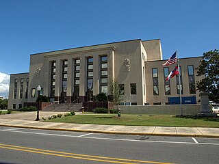
Jackson County is a county located in the U.S. state of Mississippi. As of the 2010 census, the population was 139,668, making it the fifth-most populous county in Mississippi. Its county seat is Pascagoula. The county was named for Andrew Jackson, general in the United States Army and afterward President of the United States.

Moss Point is a city in Jackson County, Mississippi, United States. The population was 13,704 at the 2010 census, down from 17,653 at the 2000 census.
Mississippi Highway 50 is a state highway in Mississippi. It generally follows an east/west track for 60 miles (97 km) and runs from MS 9 in Walthall, Mississippi, east to the Alabama state line east of Columbus. MS 50 serves the following Mississippi counties: Lowndes, Clay, and Webster.

Mississippi Highway 760 is a 1.63-mile-long (2.62 km) state highway in Tishomingo County, Mississippi. It connects the towns of Belmont and Golden.
Mississippi Highway 35 is a state highway in Mississippi. It runs north–south for 274.7 miles (442.1 km), beginning at the Louisiana state line and ending at a junction with MS 315 at Sardis Dam. MS 35 serves the counties of Marion, Jefferson Davis, Covington, Smith, Scott, Leake, Attala, Carroll, Grenada, Tallahatchie, and Panola.
Mississippi Highway 63 is a state highway in southeastern Mississippi that runs north–south for approximately 105 miles (169 km). It serves Jackson County, George County, Greene County, and Wayne County.
Mississippi Highway 26 (MS 26) is a 77.05-mile-long (124.00 km) state highway in southern Mississippi. It runs from a continuation of Louisiana Highway 10 (LA 10) east through Pearl River, Stone, and George counties to MS 198 in Lucedale. Along the way it intersects several major highways including U.S. Route 11 (US 11) in Poplarville, Interstate 59 (I-59) in Poplarville, and US 49 in Wiggins.
Mississippi Highway 13 is a state highway in Mississippi. It runs from north to south for 160.1 miles (257.7 km), serving the counties of Forrest, Pearl River, Lamar, Marion, Jefferson Davis, Simpson, Rankin, Smith, Scott, and Leake.
Mississippi Highway 17 is a state highway in central Mississippi. It runs from north to south for 70.4 miles (113.3 km), serving the counties of Madison, a small portion of Yazoo, Holmes, and Carroll.

Mississippi Highway 21 is a state highway in central Mississippi. It runs from north to south for 80.3 miles (129.2 km) and serves six counties: Scott, Leake, Newton, Neshoba, Kemper, and Noxubee.
Mississippi Highway 48 is a state highway in southern Mississippi. It runs from east to west for 83.6 miles (134.5 km), serving a total of four counties: Marion, Walthall, Pike, and Amite.
Mississippi Highway 57 is a state highway in southeastern Mississippi. It runs in a north/south direction for approximately 97.6 miles (157.1 km), serving four counties: Jackson, George, Greene, and Wayne.
Interstate 10 (I-10), a major east–west Interstate Highway in the southern areas of the United States, has a section of about 77 miles (124 km) in Mississippi.
Mississippi Highway 309 (MS 309) is a two-lane, north–south state highway in Marshall County, Mississippi. It runs 26.1 miles (42.0 km) from the Tennessee state line south through western Marshall County to its southern terminus at MS 4, just east of the community of Chulahoma.
Mississippi Highway 198 is a state highway in the U.S. state of Mississippi. The highway is the designation for six former segments of U.S. Highway 98 that have been bypassed by newer alignments. These six segments are located in Tylertown, Columbia, Hattiesburg, Beaumont, McLain, and Lucedale. Five of the six sections of MS 198 are two-lane undivided roads that pass through small towns; the exception is the Hattiesburg section which is a four-lane divided highway running through developed areas of the city. The total length of the six sections of MS 198 is 24.937 miles (40.132 km).
Mississippi Highway 612 is a highway in southeastern Mississippi. The route starts at MS 613, southwest of Lucedale. It travels southeastward through George County, crossing over Escatawpa River. The route ends at the Alabama state line, and County Road 7 continues into Mobile County. MS 612 was designated in 1966, and no significant changes have been made to the route since.
Mississippi Highway 467 is a short 15.1-mile-long (24.3 km) north-south highway located entirely in Hinds County in central Mississippi. It serves to connect the towns of Edwards and Raymond.
Mississippi Highway 614 is a 10.3-mile-long (16.6 km) east–west state highway in northeastern Jackson County, Mississippi. It connects the communities of Wade and Hurley with the Alabama state line and the city of Mobile.
Mississippi Highway 611, also known as Industrial Road, is a 4.2-mile-long (6.8 km) north–south state highway in the southeastern corner of the city of Pascagoula, in the Mississippi Gulf Coast region of Mississippi. It serves to connect the city's main industrial park, including an oil refinery, with U.S. Highway 90, MS 63, and the rest of the city. A second, 0.7-mile-long (1.1 km) segment also exists in central Pascagoula that is unsigned and maintained by the city.
Mississippi Highway 618 is a 4.91-mile-long (7.90 km) unsigned east-west state highway in Jackson County in the Mississippi Gulf Coast region of Mississippi. It connects the city of Moss Point to the community of Orange Grove.


