Escatawpa | |
---|---|
Coordinates: 30°29′21″N88°33′4″W / 30.48917°N 88.55111°W | |
Country | United States |
State | Mississippi |
County | Jackson |
Area | |
• Total | 6.92 sq mi (17.92 km2) |
• Land | 6.68 sq mi (17.30 km2) |
• Water | 0.24 sq mi (0.62 km2) |
Elevation | 13 ft (4 m) |
Population (2020) | |
• Total | 3,254 |
• Density | 487.27/sq mi (188.13/km2) |
Time zone | UTC-6 (Central (CST)) |
• Summer (DST) | UTC-5 (CDT) |
ZIP code | 39552 |
Area code | 228 |
FIPS code | 28-22900 |
GNIS feature ID | 0669806 |
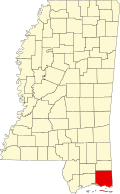
Escatawpa is an unincorporated community and census-designated place (CDP) in Jackson County, Mississippi, United States. It is part of the Pascagoula Metropolitan Statistical Area. The population was 3,254 at the 2020 census. [2]
The community takes its name from the Escatawpa River. [3] A post office called Escatawpa was established in 1885. [4]
In 1990, the original center of Escatawpa was annexed into the city of Moss Point, located just to the south. The adjoining unincorporated area north of Moss Point is the current Escatawpa census-designated place. The city was devastated by Hurricane Katrina on August 29, 2005. Escatawpa is the home of the rock band 3 Doors Down. [5] Escatawpa is six miles north of Pascagoula. [6] In 1906, the population of Escatawpa was 500. [6]
The Escatawpa CDP is in eastern Jackson County on the east side of the Pascagoula River. It is bordered to the south by the city of Moss Point. The original community of Escatawpa, now a neighborhood in Moss Point, was centered just north of present-day Interstate 10. The current CDP is 5 miles (8 km) north of the center of Moss Point and 9 miles (14 km) north of Pascagoula, the Jackson county seat. Mississippi Highway 613 is the main road through the center of Escatawpa, and four-lane Mississippi Highway 63 forms the eastern edge of the community.
According to the United States Census Bureau, the Escatawpa CDP has a total area of 6.9 square miles (17.9 km2), of which 6.7 square miles (17.3 km2) are land and 0.2 square miles (0.6 km2), or 3.49%, are water. [7]
Census | Pop. | Note | %± |
---|---|---|---|
2010 | 3,722 | — | |
2020 | 3,254 | −12.6% | |
U.S. Decennial Census [8] 2010 [9] 2020 [10] |
Race / Ethnicity (NH = Non-Hispanic) | Pop 2010 [9] | Pop 2020 [10] | % 2010 | % 2020 |
---|---|---|---|---|
White alone (NH) | 2,764 | 2,230 | 74.26% | 68.53% |
Black or African American alone (NH) | 806 | 725 | 21.66% | 22.28% |
Native American or Alaska Native alone (NH) | 20 | 24 | 0.54% | 0.74% |
Asian alone (NH) | 10 | 20 | 0.27% | 0.61% |
Pacific Islander alone (NH) | 1 | 2 | 0.03% | 0.06% |
Some Other Race alone (NH) | 0 | 10 | 0.00% | 0.31% |
Mixed Race or Multi-Racial (NH) | 23 | 142 | 0.62% | 4.36% |
Hispanic or Latino (any race) | 98 | 101 | 2.63% | 3.10% |
Total | 3,722 | 3,254 | 100.00% | 100.00% |
As of the census [11] of 2000, there were 115 people, 41 households, and 38 families residing in the CDP. The population density was 1,059.0 inhabitants per square mile (408.9/km2). There were 42 housing units at an average density of 386.8 per square mile (149.3/km2). The racial makeup of the CDP was 99.13% White, and 0.87% from two or more races.
There were 41 households, out of which 41.5% had children under the age of 18 living with them, 85.4% were married couples living together, 9.8% had a female householder with no husband present, and 4.9% were non-families. 4.9% of all households were made up of individuals, and none had someone living alone who was 65 years of age or older. The average household size was 2.80 and the average family size was 2.90.
In the CDP, the population was spread out, with 25.2% under the age of 18, 9.6% from 18 to 24, 30.4% from 25 to 44, 21.7% from 45 to 64, and 13.0% who were 65 years of age or older. The median age was 38 years. For every 100 females, there were 76.9 males. For every 100 females age 18 and over, there were 75.5 males.
The median income for a household in the CDP was $30,125, and the median income for a family was $30,125. Males had a median income of $22,361 versus $0 for females. The per capita income for the CDP was $10,243. None of the population and none of the families were below the poverty line.
As of the census [11] of 2000, there were 3,566 people, 1,310 households, and 1,002 families residing in the CDP. The population density was 552.8 inhabitants per square mile (213.4/km2). There were 1,434 housing units at an average density of 222.3 per square mile (85.8/km2). The racial makeup of the CDP was 80.45% African American, 17.64% White, 0.31% Native American, 0.73% Asian, 0.08% Pacific Islander, 0.06% from other races, and 0.73% from two or more races. Hispanic or Latino of any race were 0.59% of the population.
There were 1,310 households, out of which 35.0% had children under the age of 18 living with them, 57.2% were married couples living together, 14.1% had a female householder with no husband present, and 23.5% were non-families. 20.3% of all households were made up of individuals, and 4.7% had someone living alone who was 65 years of age or older. The average household size was 2.67 and the average family size was 3.06.
In the CDP, the population was spread out, with 25.5% under the age of 18, 9.1% from 18 to 24, 29.5% from 25 to 44, 26.8% from 45 to 64, and 9.0% who were 65 years of age or older. The median age was 36 years. For every 100 females, there were 101.1 males. For every 100 females age 18 and over, there were 97.8 males.
The median income for a household in the CDP was $41,101, and the median income for a family was $48,942. Males had a median income of $35,050 versus $20,762 for females. The per capita income for the CDP was $16,850. About 5.5% of families and 8.7% of the population were below the poverty line, including 7.2% of those under age 18 and 14.0% of those age 65 or over.
Most of Escatawpa is served by the Moss Point School District while a small portion is in the Jackson County School District. [12] The Moss Point district includes two elementary schools, one middle school, and one high school. Students in Escatawpa attend schools in Moss Point, Mississippi.
Wallace is a census-designated place (CDP) in St. John the Baptist Parish, Louisiana, United States. The population was 570 at the 2000 census. It is part of the New Orleans–Metairie–Kenner Metropolitan Statistical Area. The rural community is on the west bank of the Mississippi River and easily accessible to Interstate 10 via the Gramercy Bridge.
Mount Olive is a town in Covington County, Mississippi, United States. The population was 895 at the 2020 census.
Big Point is an unincorporated community and census-designated place (CDP) in Jackson County, Mississippi, United States. It is part of the Pascagoula, Mississippi Metropolitan Statistical Area. Per the 2020 Census, the population was 618.
Gulf Hills is an unincorporated community and census-designated place (CDP) in Jackson County, Mississippi, United States. It is part of the Pascagoula Metropolitan Statistical Area. The population was 8,526 at the 2020 census, up from 7,144 at the 2010 census.
Gulf Park Estates is an unincorporated community and census-designated place (CDP) located south of Ocean Springs in Jackson County, Mississippi, United States. It is part of the Pascagoula Metropolitan Statistical Area. The population was 5,719 at the 2010 census, up from 4,272 at the 2000 census.
Helena is an unincorporated community and census-designated place (CDP) in Jackson County, Mississippi, United States. It is part of the Moss Point Metropolitan Statistical Area. Per the 2020 Census, the population was 983.
Hickory Hill is a neighborhood in the city of Gautier in Jackson County, Mississippi, United States. Prior to 2010 it was an unincorporated area and recorded as a census-designated place, with a population of 3,046 at the 2000 census. At the 2010 census its population was included in the data for the city of Gautier. It is part of the Pascagoula Metropolitan Statistical Area.
Hurley is an unincorporated community and census-designated place (CDP) in Jackson County, Mississippi, United States. It is part of the Pascagoula Metropolitan Statistical Area. The population was 1,551 at the 2010 census, up from 985 at the 2000 census.
Latimer is a census-designated place (CDP) in Jackson County, Mississippi, United States. It is part of the Pascagoula Metropolitan Statistical Area. The population was 6,079 at the 2010 census, up from 4,288 at the 2000 census.
St. Martin is a census-designated place (CDP) in Jackson County, Mississippi, United States. It is part of the Pascagoula Metropolitan Statistical Area. The population was 7,730 at the 2010 census, up from 6,676 at the 2000 census.
Redwater is a census-designated place (CDP) in Leake County, Mississippi, United States. It is one of the eight communities of the Mississippi Band of Choctaw Indians Reservation, and the population is 61% Choctaw. The population was 633 at the 2010 census, up from 409 at the 2000 census.
Standing Pine is a census-designated place (CDP) in Leake County, Mississippi, United States. It is one of the eight communities of the Mississippi Band of Choctaw Indians Reservation, and the population is 94% Choctaw. The total population of the CDP was 517 at the 2020 census.
Tucker is a census-designated place (CDP) in Neshoba County, Mississippi. It is one of the eight communities of the Mississippi Band of Choctaw Indians Reservation and the population is 93% Choctaw. The population was 642 at the 2020 census.
Vancleave is an unincorporated community and census-designated place (CDP) in Jackson County, Mississippi, United States. It is part of the Pascagoula Metropolitan Statistical Area. The population was 5,886 at the 2010 census, up from 4,910 at the 2000 census.
Wade is an unincorporated community and census-designated place (CDP) in Jackson County, Mississippi, United States. It is part of the Pascagoula Metropolitan Statistical Area. The population was 1,074 at the 2010 census, up from 491 at the 2000 census.
Collinsville is an unincorporated community and census-designated place (CDP) in Lauderdale County, Mississippi, United States. The population was 1,984 at the 2020 census.
Nellieburg is an unincorporated community and census-designated place (CDP) in Lauderdale County, Mississippi, United States. The population was 1,316 at the 2020 census. It is a suburb of Meridian.
The Gulfport–Biloxi Metropolitan Statistical Area is a metropolitan statistical area (MSA) in the Mississippi Gulf Coast region that includes four counties – Hancock, Harrison, Jackson and Stone. The principal cities are Gulfport and Biloxi. The 2010 census placed the Gulfport-Biloxi MSA population at 388,488, though as of 2019, it was estimated to have increased to 417,665. The area was significantly impacted by Hurricane Katrina on August 29, 2005, and prior to the hurricane, had experienced steady to moderate population growth. However, growth has since rebounded, with the population steadily increasing every year throughout the 2010s.
The Pascagoula Metropolitan Statistical Area was a metropolitan area in the southeastern corner of Mississippi that covered two counties - Jackson and George. As of the 2000 census, the MSA had a population of 150,564. The area was significantly impacted by Hurricane Katrina in 2005. A July 1, 2009 estimate placed the population at 155,603. Prior to the hurricane, the area had experienced steady population growth. It was also part of the larger Gulfport-Biloxi-Pascagoula Combined Statistical Area.
The Gulfport–Biloxi–Pascagoula Combined Statistical Area is made up of five counties in the Mississippi Gulf Coast region. The statistical area consists of the Gulfport–Biloxi Metropolitan Statistical Area and the Pascagoula Metropolitan Statistical Area. The 2010 census placed the CSA population at 411,066, and as of 2019, is estimated to be 442,165. The area was significantly impacted by Hurricane Katrina on August 29, 2005, although population growth has steadily rebounded in recent years.
{{cite web}}
: Missing or empty |title=
(help){{cite web}}
: Missing or empty |title=
(help); Missing or empty |url=
(help)