Poticaw Landing, Mississippi | |
|---|---|
 Poticaw Landing  Poticaw Landing | |
| Coordinates: 30°30′43″N88°37′08″W / 30.51194°N 88.61889°W | |
| Country | United States |
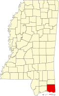
| State | Mississippi |
| County | Jackson |
| Elevation | 10 ft (3 m) |
| Time zone | UTC-6 (Central (CST)) |
| • Summer (DST) | UTC-5 (CDT) |
| GNIS feature ID | 692156 |
Poticaw Landing is an unincorporated community in Jackson County, in the U.S. state of Mississippi. [1]