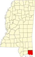
St. Martin, Mississippi | |
---|---|
Coordinates: 30°26′31″N88°52′13″W / 30.44194°N 88.87028°W | |
Country | United States of America |
State | Mississippi |
County | Jackson |
Area | |
• Total | 5.15 sq mi (13.34 km2) |
• Land | 4.29 sq mi (11.11 km2) |
• Water | 0.86 sq mi (2.23 km2) |
Elevation | 13 ft (4 m) |
Population (2020) | |
• Total | 7,811 |
• Density | 1,821.17/sq mi (703.08/km2) |
Time zone | UTC-6 (Central (CST)) |
• Summer (DST) | UTC-5 (CDT) |
ZIP codes | 39564, 39532 |
Area code | 228 |
FIPS code | 28-64680 |
GNIS feature ID | 1867332 |
St. Martin is a census-designated place (CDP) in Jackson County, Mississippi, United States. It is part of the Pascagoula Metropolitan Statistical Area. The population was 7,730 at the 2010 census, [2] up from 6,676 at the 2000 census.
St. Martin is located along the Mississippi Gulf Coast at 30°26′31″N88°52′13″W / 30.44194°N 88.87028°W (30.441847, -88.870402). [3] It is south of Interstate 10 and is bordered by the CDP of Gulf Hills to the east, Biloxi Bay to the south, and the city of D'Iberville to the west.
According to the United States Census Bureau, the CDP has a total area of 5.1 square miles (13.2 km2), of which 4.2 square miles (11.0 km2) are land and 0.85 square miles (2.2 km2), or 16.84%, are water. St. Martin has either Biloxi or Ocean Springs mailing addresses. The ZIP codes are either 39532 or 39564.
Census | Pop. | Note | %± |
---|---|---|---|
2020 | 7,811 | — | |
U.S. Decennial Census [4] |
Race | Num. | Perc. |
---|---|---|
White (non-Hispanic) | 4,935 | 63.18% |
Black or African American (non-Hispanic) | 1,164 | 14.9% |
Native American | 46 | 0.59% |
Asian | 735 | 9.41% |
Pacific Islander | 12 | 0.15% |
Other/Mixed | 445 | 5.7% |
Hispanic or Latino | 474 | 6.07% |
As of the 2020 United States census, there were 7,811 people, 2,977 households, and 1,645 families residing in the CDP.
As of the census [6] of 2000, there were 6,676 people, 2,387 households, and 1,833 families residing in the CDP. The population density was 1,528.0 inhabitants per square mile (590.0/km2). There were 2,534 housing units at an average density of 580.0 per square mile (223.9/km2). The racial makeup of the CDP was 82.70% White, 7.94% African American, 0.52% Native American, 6.95% Asian, 0.07% Pacific Islander, 0.42% from other races, and 1.39% from two or more races. Hispanic or Latino of any race were 1.92% of the population.
There were 2,387 households, of which 36.5% had children under the age of 18 living with them, 56.6% were married couples living together, 14.7% had a female householder with no husband present, and 23.2% were non-families. 18.6% of all households were made up of individuals, and 7.5% had someone living alone who was 65 years of age or older. The average household size was 2.80 and the average family size was 3.17.
In the CDP, the population was spread out, with 27.3% under the age of 18, 8.7% from 18 to 24, 29.7% from 25 to 44, 23.8% from 45 to 64, and 10.5% who were 65 years of age or older. The median age was 36 years. For every 100 females, there were 96.6 males. For every 100 females age 18 and over, there were 94.1 males.
The median income for a household in the CDP was $41,167, and the median income for a family was $46,559. Males had a median income of $31,213 versus $22,958 for females. The per capita income for the CDP was $16,439. About 7.1% of families and 10.7% of the population were below the poverty line, including 14.0% of those under age 18 and 20.7% of those age 65 or over.
The West Jackson County Fire Department provides fire protection for the community.
The Jackson County Sheriff's Office provides law enforcement services for the community.
St. Martin is served by the Jackson County School District. [7] It includes three elementary schools, one middle school, and one high school. St. Martin is also home to a branch of the Jackson-George Regional Library, located at 15004 LeMoyne Boulevard.
These schools have been consecutively rated as Tier 5 schools due to their excellence.
Theodore is an unincorporated area and census-designated place (CDP) in Mobile County, Alabama, United States. The population was 6,270 at the 2020 census. It is a part of the Mobile metropolitan area. Prior to 1900 this area was known as "Clements", but it is now named for William Theodore Hieronymous, a sawmill operator and postmaster.
Jacksonville is a city in Pulaski County, Arkansas, United States, and a suburb of Little Rock. As of the 2010 census, the population of the city was 28,364. It is part of the Little Rock–North Little Rock–Conway Metropolitan Statistical Area with 729,135 people as of 2014.
Olympia Heights is a census-designated place in Miami-Dade County, Florida, United States. The population was 12,873 at the 2020 census.
The Hammocks is a planned community and census-designated place in Miami-Dade County, Florida, United States. The population was 59,480 at the 2020 census, up from 51,003 in 2010.
Reed Creek is a census-designated place (CDP) in Hart County, Georgia, United States. The population was 2,604 at the 2010 census, up from 2,148 at the 2000 census.
Crystal Lawns is a census-designated place (CDP) in Will County, Illinois, United States. The population was 1,830 at the 2020 census.
Luling is a census-designated place (CDP) in St. Charles Parish, Louisiana. The population was 11,512 at the 2000 census and 12,119 at the 2010 census. At the 2020 census, 13,716 people lived in Luling.
Napoleon is an unincorporated community and census-designated place (CDP) in Jackson County in the U.S. state of Michigan. The population of the CDP was 1,258 at the 2010 census. It is located within Napoleon Township.
Big Point is an unincorporated community and census-designated place (CDP) in Jackson County, Mississippi, United States. It is part of the Pascagoula, Mississippi Metropolitan Statistical Area. Per the 2020 Census, the population was 618.
Escatawpa is an unincorporated community and census-designated place (CDP) in Jackson County, Mississippi, United States. It is part of the Pascagoula Metropolitan Statistical Area. The population was 3,254 at the 2020 census.
Gulf Hills is an unincorporated community and census-designated place (CDP) in Jackson County, Mississippi, United States. It is part of the Pascagoula Metropolitan Statistical Area. The population was 8,526 at the 2020 census, up from 7,144 at the 2010 census.
Gulf Park Estates is an unincorporated community and census-designated place (CDP) located south of Ocean Springs in Jackson County, Mississippi, United States. It is part of the Pascagoula Metropolitan Statistical Area. The population was 5,719 at the 2010 census, up from 4,272 at the 2000 census.
Hickory Hill is a neighborhood in the city of Gautier in Jackson County, Mississippi, United States. Prior to 2010 it was an unincorporated area and recorded as a census-designated place, with a population of 3,046 at the 2000 census. At the 2010 census its population was included in the data for the city of Gautier. It is part of the Pascagoula Metropolitan Statistical Area.
Hurley is an unincorporated community and census-designated place (CDP) in Jackson County, Mississippi, United States. It is part of the Pascagoula Metropolitan Statistical Area. The population was 1,551 at the 2010 census, up from 985 at the 2000 census.
Latimer is a census-designated place (CDP) in Jackson County, Mississippi, United States. It is part of the Pascagoula Metropolitan Statistical Area. The population was 6,079 at the 2010 census, up from 4,288 at the 2000 census.
Vancleave is an unincorporated community and census-designated place (CDP) in Jackson County, Mississippi, United States. It is part of the Pascagoula Metropolitan Statistical Area. The population was 5,886 at the 2010 census, up from 4,910 at the 2000 census.
Wade is an unincorporated community and census-designated place (CDP) in Jackson County, Mississippi, United States. It is part of the Pascagoula Metropolitan Statistical Area. The population was 1,074 at the 2010 census, up from 491 at the 2000 census.
Concord is a census-designated place (CDP) in St. Louis County, Missouri, United States. The population was 16,421 at the 2010 census. It should not be confused with Concord Township; which the CDP shares much land with, but these areas' boundaries are not identical.
Vista West is a census-designated place (CDP) in Natrona County, Wyoming, United States. It is part of the Casper, Wyoming Metropolitan Statistical Area. The population was 951 at the 2010 census.
Carter is a census-designated place (CDP) in Uinta County, Wyoming, United States. Established by the United States Census Bureau in 1980, the CDP was named after the former village of Carter, in turn named for Judge William A. Carter, which was located within the CDP and of which some abandoned buildings remain standing. The population of the CDP was 10 at the 2010 census.