Monoharpur is a village in Chanditala II CD Block in Srirampore subdivision of Hooghly district in the state of West Bengal, India. It was earlier recorded as a census town.
Naspur is a municipality and a suburb and mandal in Mancherial district of the Indian state of Telangana. Located the north bank of Godavari River.
Nagayalanka is a village in Krishna district of Indian state of Andhra Pradesh. It is the mandal headquarters of Nagayalanka mandal in Machilipatnam revenue division.

Ramgarh is an upazila of Khagrachhari District in Chattogram Division, Bangladesh.

Jamalpur Sadar is an upazila of Jamalpur District in the Division of Mymensingh, Bangladesh.

Gopalpur is an upazila of Tangail District in the Division of Dhaka, Bangladesh.

Tangail Sadar is an upazila of Tangail District in the Division of Dhaka, Bangladesh.
Munagapaka is a village in Anakapalli district in the state of Andhra Pradesh in India. Munagapaka pin code 531033. In Munagapaka there are nearly more than 2000 houses with population more than 8000. Munagapaka is under the Yelamanchili constituency. Munagapaka is also the mandal center for nearly 35 villages.
Sarsanda is a village in the Aantroli Kalan Gram Panchayat of the Degana Tehsil of the Nagaur District of the Rajasthan State of India. It is 117 km driving distance from Nagaur, at 26.81488°N 74.16318°E.

Port-Salut is an arrondissement in the Sud department of Haiti. As of 2015, the population was 73,845 inhabitants. Postal codes in the Port-Salut Arrondissement start with the number 82.
Vallières is an arrondissement in the Nord-Est department of Haiti. As of 2015, the population was 71,851 inhabitants. Postal codes in the Vallières Arrondissement start with the number 24.
Yaliwal is a village in the southern state of Karnataka, India. It is located in the Kundgol taluk of Dharwad district in Karnataka.
Kasaragod or Casrod a taluk which along with Hosdurg taluk, Manjeshwaram Taluk and Vellarikundu taluk constitute the Kasaragod district, Kerala, India. Its educational center is Vidyanagar. The major areas include Kasaragod municipality, Chemnad, Bedira, and Chengala. The Central Plantation Crops Research Institute is located in the taluk.

Buttar Sivia, also known as Buttar Siviya, is a village in the Amritsar district of Punjab, India. It is predominantly inhabited by people of the Buttar, Siviya, and Randhawa Jat clans.
Buthpur or Bhoothpur is a large area in Mahbubnagar district, Telangana.
Gettupatti is a village in Dharmapuri District of Tamil Nadu State, India.
It comes under Dokkubothanahalli Panchayath and its south regions is covered by thoppur forest.
It is located 20 km towards South from Dharmapuri and 308 km from State capital Chennai.
Bori is a village in Jintur taluka of Parbhani district in Maharashtra state of India.
Nanagwas is a small village located in Neemrana Tehsil of Kotputali Bheror District, Rajasthan, India.

Pilisvörösvár is a district in north-western part of Pest County. Pilisvörösvár is also the name of the town where the district seat is found. The district is located in the Central Hungary Statistical Region.
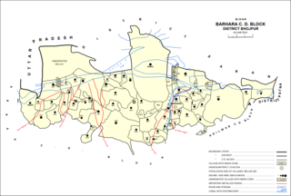
Barhara, also spelled Badahara is a Gram Panchayat and corresponding community development block in Bhojpur District of Bihar, India. It is situated on the bank of the river Ganges. By the time of July–August most of the villages under this block are affected by deluge. As of 2011, its population was 6,889, in 927 households, while the total block population was 240,636, in 35,185 households.


