
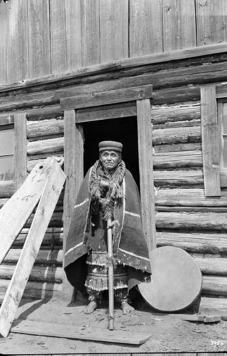
The Tlingit or Lingít are Alaska Native Indigenous Peoples of the Pacific Northwest Coast of North America and are one of two-hundred twenty-nine (229) federally recognized Tribes of Alaska. Their language is the Tlingit language, in which the name means 'People of the Tides'.

Bennett Lake is a lake in the Province of British Columbia and Yukon Territory in northwestern Canada, at an elevation of 642 m (2,106 ft). It is just north of the border with the United States state of Alaska, near the Alaskan port of Skagway.
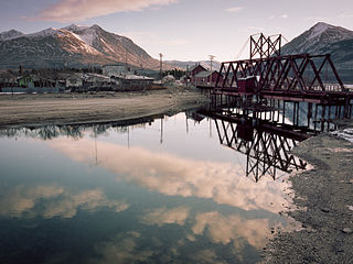
Carcross, originally known as Caribou Crossing, is an unincorporated community in Yukon, Canada, on Bennett Lake and Nares Lake. It is home to the Carcross/Tagish First Nation.
The Klondike Highway is a highway that runs from the Alaska Panhandle through the province of British Columbia and the territory of Yukon in Canada, linking the coastal town of Skagway, Alaska, to Dawson City, Yukon. Its route somewhat parallels the route used by prospectors in the 1898 Klondike Gold Rush.
The Tagish or Tagish Khwáan are a First Nations people of the Athabaskan-speaking ethnolinguistic group that lived around Tagish Lake and Marsh Lake, in Yukon of Canada. The Tagish intermarried heavily with Tlingit from the coast and the Tagish language became extinct in 2008. Today Tagish people live mainly in Carcross or Whitehorse and are members of the Carcross/Tagish First Nation or the Kwanlin Dün First Nation.
Tagish Lake is a lake in Yukon and northern British Columbia, Canada. The lake is more than 100 km (62 mi) long and about 2 km (1 mi) wide.
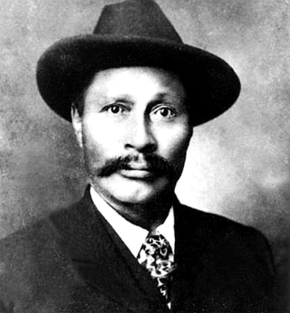
Keish, also known as James Mason and by the nickname Skookum Jim Mason, was a member of the Tagish First Nation in what became the Yukon Territory of Canada. He was born near Bennett Lake, on what is now the Yukon–British Columbia border. He lived in Caribou Crossing, now Carcross, Yukon.

Shaaw Tláa, also known as Kate Carmack, was a Tagish First Nation woman who was one of the party that first found gold in the Klondike River in 1896, and is sometimes credited with being the person who made the actual discovery.
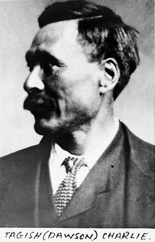
Dawson Charlie or K̲áa Goox̱ [qʰáː kuːχ] was a Canadian Tagish/Tlingit First Nation person and one of the co-discoverers of gold at Discovery Claim that led to the Klondike Gold Rush located in the Yukon territory of Northwest Canada. He was the nephew of Keish, also known as Skookum Jim Mason, and accompanied him on his search for his aunt, Kate Carmack. He staked one of the first three claims in the Klondike, along with his uncle and George Carmack. Storyteller Angela Sidney was a niece.

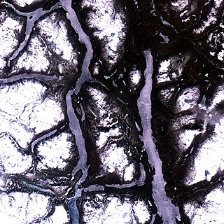
Yukon is in the northwestern corner of Canada and is bordered by Alaska and the Northwest Territories. The sparsely populated territory abounds with natural scenery, snowmelt lakes and perennial white-capped mountains, including many of Canada's highest mountains. The territory's climate is Arctic in territory north of Old Crow, subarctic in the region, between Whitehorse and Old Crow, and humid continental climate south of Whitehorse and in areas close to the British Columbia border. Most of the territory is boreal forest with tundra being the main vegetation zone only in the extreme north and at high elevations.

Tatshenshini-Alsek Park or Tatshenshini-Alsek Provincial Wilderness Park is a provincial park in British Columbia, Canada 9,580 km2 (3,700 sq mi). It was established in 1993 after an intensive campaign by Canadian and American conservation organizations to halt mining exploration and development in the area, and protect the area for its strong natural heritage and biodiversity values.
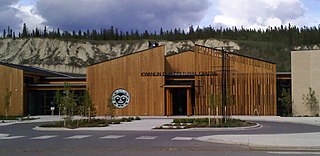
The Kwanlin Dün First Nation (KDFN) or Kwänlin Dän kwächʼǟn is located in and around Whitehorse in Yukon, Canada.

The Carcross/Tagish First Nation is a First Nation native to the Canadian territory of Yukon. Its original population centres were Carcross and Tagish, and Squanga, although many of its citizens also live in Whitehorse. The languages originally spoken by Carcross/Tagish people were Tagish and Tlingit.
Tagish was a language spoken by the Tagish or Carcross-Tagish, a First Nations people that historically lived in the Northwest Territories and Yukon in Canada. The name Tagish derives from /ta:gizi dene/, or "Tagish people", which is how they refer to themselves, where /ta:gizi/ is a place name meaning "it is breaking up.
Southern Lakes was an electoral district in rural Yukon which returned a member to the Legislative Assembly of the Yukon in Canada. It was one of the eight rural ridings in the Yukon at the time.
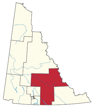
Pelly-Nisutlin is an electoral district which returns a member to the Legislative Assembly of the Yukon Territory in Canada. It was created in 2002 out of the districts of Faro and Ross River-Southern Lakes. The riding includes the communities of Teslin, Faro, Ross River, Little Salmon, and Johnsons Crossing. It encompasses the traditional territory of the Teslin Tlingit Council and the Ross River Dena Council of the Kaska Dena. Pelly-Nisutlin is bordered by the rural ridings of Mayo-Tatchun, Lake Laberge, Mount Lorne-Southern Lakes, and Watson Lake.

The history of Yukon covers the period from the arrival of Paleo-Indians through the Beringia land bridge approximately 20,000 years ago. In the 18th century, Russian explorers began to trade with the First Nations people along the Alaskan coast, and later established trade networks extending into Yukon. By the 19th century, traders from the Hudson's Bay Company were also active in the region. The region was administered as a part of the North-Western Territory until 1870, when the United Kingdom transferred the territory to Canada and it became the North-West Territories.

The Indigenous peoples of Yukon are ethnic groups who, prior to European contact, occupied the former countries now collectively known as Yukon. While most First Nations in the Canadian territory are a part of the wider Dene Nation, there are Tlingit and Métis nations that blend into the wider spectrum of indigeneity across Canada. Traditionally hunter-gatherers, indigenous peoples and their associated nations retain close connections to the land, the rivers and the seasons of their respective countries or homelands. Their histories are recorded and passed down the generations through oral traditions. European contact and invasion brought many changes to the native cultures of Yukon including land loss and non-traditional governance and education. However, indigenous people in Yukon continue to foster their connections with the land in seasonal wage labour such as fishing and trapping. Today, indigenous groups aim to maintain and develop indigenous languages, traditional or culturally-appropriate forms of education, cultures, spiritualities and indigenous rights.
The Yukon Ice Patches are a series of dozens of ice patches in the southern Yukon discovered in 1997, which have preserved hundreds of archaeological artifacts, with some more than 9,000 years old. The first ice patch was discovered on the mountain Thandlät, west of the Kusawa Lake campground which is 60 km (37 mi) west of Whitehorse, Yukon. The Yukon Ice Patch Project began shortly afterwards with a partnership between archaeologists in partnership with six Yukon First Nations, on whose traditional territory the ice patches were found. They include the Carcross/Tagish First Nation, the Kwanlin Dün First Nation, the Ta’an Kwäch’än Council, the Champagne and Aishihik First Nations, the Kluane First Nation, and the Teslin Tlingit Council.

