The Bosque del Apache National Wildlife Refuge is located in southern New Mexico. It was founded in 1939 and is administered by the U.S. Fish and Wildlife Service. It is a favorite spot to watch the migration of the sandhill cranes in the fall. The reserve is open year-round and provides safe harbor for its varied wildlife.
Merritt Island National Wildlife Refuge is a 140,000 acres (57,000 ha) U.S. National Wildlife Refuge (NWR) on the Atlantic coast of Florida's largest barrier island. NASA's Kennedy Space Center and visitor complex are also situated on the island and NASA can restrict access to the refuge based on its operational needs.

The Virgin Islands National Park is an American national park preserving about 60% of the land area of Saint John in the United States Virgin Islands, as well as more than 5,500 acres of adjacent ocean, and nearly all of Hassel Island, just off the Charlotte Amalie, Saint Thomas harbor.

Quivira National Wildlife Refuge in south central Kansas, United States, includes rare inland marshes. Located near the town of Stafford, it lies mostly in northeastern Stafford County, but small parts extend into southwestern Rice and northwestern Reno Counties. Its proximity to the Central Flyway migration route and the salt marshes on the refuge combine to endow the refuge with a large variety of birds. Many of these birds are uncommon in other parts of Kansas or even the central part of the continent.

Mount Chirripó is the highest mountain in Costa Rica, with an elevation of 3,821 meters. It is part of the Cordillera de Talamanca, and the range's highest point. It is located in Chirripó National Park and is noted for its ecological wealth. The mountain was named "Chirripo", meaning "land of eternal waters", by indigenous Costa Ricans because there are many lakes and streams around the mountain. The high peaks in Chirripó National Park and La Amistad International Park host important areas of Talamancan montane forest and Costa Rican Páramo with high endemism and extremely high biodiversity. The peaks of these mountains constitute sky islands for many species of plants and animals. Snow has not fallen on the peak in the past 100 years or so, according to the University of Costa Rica, but hail is sometimes reported.

The Arthur R. Marshall Loxahatchee National Wildlife Refuge is a 145,188-acre (587.55 km2) wildlife sanctuary is located west of Boynton Beach, in Palm Beach County, Florida. It is also known as Water Conservation Area 1 (WCA-1). It includes the most northern remnant of the historic Everglades wetland ecosystem.

The Okefenokee National Wildlife Refuge is a 402,000‑acre (1,627 km2) National Wildlife Refuge located in Charlton, Ware, and Clinch Counties of Georgia, and Baker County in Florida, United States. The refuge is administered from offices in Folkston, Georgia. The refuge was established in 1937 to protect a majority of the 438,000 acre (1,772 km2) Okefenokee Swamp. The name "Okefenokee" is a Native American word meaning "trembling earth."

Sam D. Hamilton Noxubee National Wildlife Refuge is a 48,000 acres (190 km2) National Wildlife Refuge located in the U.S. state of Mississippi, in Noxubee, Oktibbeha, and Winston Counties. The refuge serves as a resting and feeding area for migratory birds and as example of proper land stewardship. Also, the refuge extensively manages land for the endangered red-cockaded woodpecker.
The Savannah National Wildlife Refuge is a 31,551-acre (12,768 ha) National Wildlife Refuge located in Chatham and Effingham counties in Georgia and Jasper County in South Carolina. Of the total area, 15,395 acres (6,230 ha) is in Georgia and 15,263 acres (6,177 ha) is in South Carolina. The refuge was established to provide sanctuary for migratory waterfowl and other birds and as a nature and forest preserve for aesthetic and conservation purposes.
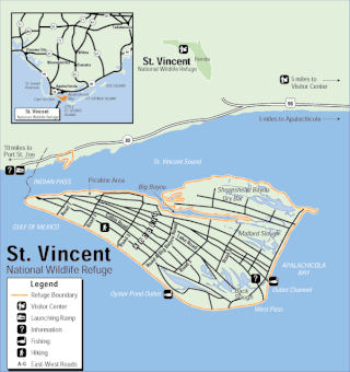
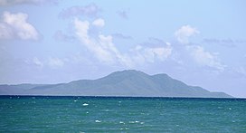
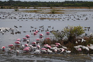
The St. Vincent National Wildlife Refuge is part of the United States National Wildlife Refuge System, located in northwestern Florida, on the barrier island of St. Vincent, off the coast of Apalachicola in the Gulf of Mexico. The Refuge includes Pig Island, located in the southwest corner of St. Joseph Bay, nearly 9 miles west of St. Vincent and 86 acres of mainland Florida along Franklin county road 30A. The 12,490 acre (51km2) refuge was established in 1968.
Caribbean Islands National Wildlife Complex is an administrative unit of the United States Fish and Wildlife Service which oversees National Wildlife Refuges in Puerto Rico, the U.S. Virgin Islands, and Navassa Island of the U.S. Minor Outlying Islands. The NWR complex also manages the reintroduction of the critically endangered Puerto Rican parrot into the wild.
The Des Lacs National Wildlife Refuge is located in the U.S. state of North Dakota and extends from the Canada–United States border to near the town of Kenmare, North Dakota along Des Lacs Lake. The refuge was established in 1935 and includes 19,500 acres (78.9 km2). The refuge is considered to be one of the most important bird sanctuaries in the U.S., with tens of thousands of birds using the refuge for migration and breeding. The refuge is also home to elk, moose, bison and pronghorn.

Libidibia monosperma is a species of legume in the family Fabaceae, with the common names cóbana negra and cóbana polisandro. It is found in the Dominican Republic, Puerto Rico, and the United States Virgin Islands. It is a federally listed threatened species of the United States.
Myrcia neothomasiana, commonly known as Thomas' lidflower, is a rare species of plant in the family Myrtaceae. It is found on three Caribbean islands. There are fewer than 250 individuals total divided amongst the islands of Vieques in Puerto Rico, St. John in the United States Virgin Islands, and Virgin Gorda in the British Virgin Islands. It has been extirpated from the wild on Saint Thomas, U.S. Virgin Islands, where it was first described in 1855, and now only grows there in cultivation.

The Patuxent Research Refuge is a National Wildlife Refuge in Prince George's County, Maryland, United States, established in 1936 by executive order of President Franklin D. Roosevelt. It is the only National Wildlife Refuge in the country established to support wildlife research. With land surrounding the Patuxent and Little Patuxent Rivers between Washington, D.C., and Baltimore, Maryland, the refuge has grown from the original 2,670 acres (10.8 km2) to its present size of over 12,800 acres (52 km2) and encompasses land formerly managed by the Departments of Agriculture and Defense. Throughout decades of change, Patuxent's mission of conserving and protecting the nation's wildlife and habitat through research and wildlife management techniques has remained virtually unchanged.

Bosque del Apache Wilderness is a designated Wilderness Area on the Bosque del Apache National Wildlife Refuge in Socorro County, New Mexico. Managed by the U.S. Fish and Wildlife Service, the Wilderness, established in 1975, contains 30,427 acres distributed between three units.

Caracas Beach, also known as Red Beach in English, is a beach on the southern coast of Vieques in the barrio of Puerto Ferro. The beach is famous for its white sand, its clear blue waters, tidal pools and shallow cove perfect for snorkeling. It used to be considered remote but it is now easily reachable through a paved road. The beach has also been developed for visitors with picnic areas, bathrooms and a large parking area. It is located in and managed by the Vieques National Wildlife Refuge and there is also a trail that leads to a nearby hill that offers beautiful views of the beach and cove.
Esperanza Beach is a popular beach on the southern coast of Vieques in La Esperanza, Puerto Real. In comparison to other beaches in the island which are located far away from populated areas, this beach is located close to La Esperanza and it hosts a number of hotels, restaurants, food kiosks and stores. Esperanza Pier, located on the western part of the beach, is considered a landmark of Vieques. It is a very popular weekend destination for locals and visitors alike. The beach is located between Sun Bay Beach and Black Sand Beach and both can be reached by foot from La Esperanza.

Humacao Nature Reserve, or the Punta Santiago Nature Reserve, is a nature reserve located in the southeastern coast of Puerto Rico, between the municipalities of Humacao and Naguabo (Río). The 3,000-acre nature reserve was established in 1986 to protect and preserve the remaining Pterocarpus forest ecosystem in the area, along with its surrounding wetlands and mangrove forests.