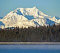
Mount Bertha

Last updated
Mount Bertha
Mount Bertha.jpg
Mt. Bertha, aerial view
Highest point
Elevation 10,204 ft (3,110 m) [1]
Prominence 3,454 ft (1,053 m) [1]
Parent peak Mount Crillon (12,726 ft) [2]
Isolation 3.51 mi (5.65 km) [2]
Coordinates 58°41′12″N137°01′38″W / 58.68667°N 137.02722°W / 58.68667; -137.02722 [1]
Geography
Relief map of USA Alaska.png
Red triangle with thick white border.svg
Mount Bertha
Location of Mount Bertha in Alaska
CountryUnited States
State Alaska
Census Area Hoonah–Angoon
Protected area Glacier Bay National Park
Parent range Fairweather Range
Saint Elias Mountains [1]
Topo map USGS Mount Fairweather C-4
Climbing
First ascent July 30, 1940 Bradford Washburn
Easiest route Mountaineering

Mount Bertha is a 10,204-foot (3,110 meter) glaciated mountain summit located in the Fairweather Range of the Saint Elias Mountains, in southeast Alaska, United States.

Contents

Geography and naming

The peak is situated in Glacier Bay National Park, 5.5 mi (9 km) east-northeast of Mount Crillon which is the nearest higher peak, and 23.5 mi (38 km) southeast of Mount Fairweather, which is the highest peak in the Fairweather Range. The mountain's name first appeared in 1910 when published by the United States Coast and Geodetic Survey. [3] The United States Geological Survey claims it was named after SS Bertha, an Alaska Commercial Company steamer in service from 1888 until it wrecked at Uyak Bay on July 18, 1915. [4] However, according to Bradford Washburn of the Boston Museum of Science and American Mountaineering Museum, this feature was named for a prostitute in Skagway, Alaska, known by members of the International Boundary Commission who surveyed the area. [5]

Climbing history

The first ascent of the peak was made July 30, 1940, by Bradford Washburn, his wife Barbara Washburn, Maynard Miller, Michl Feuersinger, and Thomas Winship. [6] It was the first mountain climbing experience for Barbara, and Bradford would later refer to the expedition as their honeymoon since they had recently married in April. After the expedition she would learn that she was several months pregnant. In 1947 she became the first woman to summit Denali. The months May through June offer the most favorable weather for climbing and viewing.

Climate

Based on the Köppen climate classification, Mount Bertha has a subarctic climate with cold, snowy winters, and mild summers. [7] Weather systems coming off the Gulf of Alaska are forced upwards by the Fairweather Range (orographic lift), causing heavy precipitation in the form of rainfall and snowfall. Winter temperatures can drop below −20 °C with wind chill factors below −30 °C. This climate supports hanging glaciers on its slopes as well as the immense Brady Glacier to the south, Reid Glacier to the northeast, and Johns Hopkins Glacier to the northwest. Precipitation runoff and meltwater from its glaciers drains into Glacier Bay and the Gulf of Alaska.

See also

Related Research Articles

<span class="mw-page-title-main">Mount Fairweather</span> Highest mountain in British Columbia, Canada

Mount Fairweather is 20 km (12 mi) east of the Pacific Ocean on the Canada–United States border between Alaska and western British Columbia and has an elevation of 4,653 metres (15,266 ft). Most of the mountain lies within Glacier Bay National Park and Preserve in the City and Borough of Yakutat, Alaska, though the summit borders Tatshenshini-Alsek Provincial Park, British Columbia. Tsalxaan is officially gazetted as Fairweather Mountain in Canada but referred to as Mount Fairweather, and is the highest mountain in the Canadian province of British Columbia. It is also designated as Boundary Peak 164 or as US/Canada Boundary Point #164.

<span class="mw-page-title-main">Mount Hayes</span> Mountain in Alaska, United States

Mount Hayes is the highest mountain in the eastern Alaska Range, in the U.S. state of Alaska. Despite not being a fourteener, it is one of the largest peaks in the United States in terms of rise above local terrain. For example, the Northeast Face rises 8,000 feet (2,440 m) in approximately 2 miles (3.2 km). This large vertical relief contributes to Mount Hayes being the 51st most topographically prominent peak in the world.

Henry Bradford Washburn Jr. was an American explorer, mountaineer, photographer, and cartographer. He established the Boston Museum of Science, served as its director from 1939–1980, and from 1985 until his death served as its Honorary Director. Bradford married Barbara Polk in 1940, they honeymooned in Alaska making the first ascent of Mount Bertha together.

<span class="mw-page-title-main">Mount Crillon</span> Mountain in Alaska

Mount Crillon is a high peak of the Fairweather Range, the southernmost part of the Saint Elias Mountains. It lies southeast of Mount Fairweather, in the promontory between the Gulf of Alaska and Glacier Bay. It is included in Glacier Bay National Park. The peak was named after Felix-Francois-Dorothee de Bretton, Comte de Crillon, by his friend, the French explorer Jean Francois de Galaup de la Perouse.

<span class="mw-page-title-main">Mount Abbe</span> Mountain in Alaska, United States

Mount Abbe is an 8200+ feet double summit mountain located in the Fairweather Range of the Saint Elias Mountains, in southeast Alaska. The peak is situated near the terminus of the Johns Hopkins Glacier, within Glacier Bay National Park and Preserve, 100 mi (161 km) northwest of Juneau, and 8.2 mi (13 km) northeast of Mount Orville. Although modest in elevation, relief is significant since the mountain rises up from tidewater in less than two miles. Mount Abbe is often seen and photographed with the Johns Hopkins Glacier, which is a popular destination for cruise ships. The mountain was named in 1936 by William Osgood Field and William Skinner Cooper, of the American Geographical Society, for Cleveland Abbe Jr., (1872-1934), an American geographer. Abbe received a Ph.D. in 1898 from Johns Hopkins University. The Gilman Glacier and Clark Glacier on the mountain's slopes were named for Daniel Coit Gilman, the institution's first president, and William Bullock Clark who was a professor of geology at the university. The mountain's name was officially adopted in 1937 by the United States Geological Survey. The first ascent of the south summit was made June 11, 1977, by Jim Wickwire and Dusan Jagersky via the Southeast Face. Three days later, Dusan Jagersky was killed while descending an unnamed peak. The first ascent of the north summit was made July 14, 1991, by Walter Gove and William Pilling. The months May through June offer the most favorable weather for climbing Mount Abbe, but it's a challenging climb in any conditions, with few attempts.

<span class="mw-page-title-main">Mount Cooper (Alaska)</span> Mountain in Alaska

Mount Cooper is a 6780-foot (2067-meter) mountain summit located in the Fairweather Range of the Saint Elias Mountains, in southeast Alaska. The peak is situated in Glacier Bay National Park and Preserve at the entrance to Johns Hopkins Inlet, 100 mi (161 km) northwest of Juneau, and 5.6 mi (9 km) northeast of Mount Abbe, which is the nearest higher peak. Although modest in elevation, relief is significant since the mountain rises up from tidewater in less than two miles. Mount Cooper can be seen from Johns Hopkins Inlet which is a popular destination for cruise ships. The mountain's name was proposed in the 1950s for William Skinner Cooper (1884-1978), a plant ecologist who performed vegetation-glacier relationship studies in the Glacier Bay area, and was chairman of the committee of scientists which proposed establishing Glacier Bay National Monument. The mountain's name was officially adopted in 1980 by the United States Geological Survey following Cooper's death. The months May through June offer the most favorable weather for climbing Mount Cooper.

<span class="mw-page-title-main">Mount Forde (Fairweather Range)</span> Mountain on the United States-Canada border

Mount Forde, also known as Boundary Peak 161, is a 6,883-foot (2,098 m) mountain summit located in the Fairweather Range of the Saint Elias Mountains, on the Canada–United States border between southeast Alaska and British Columbia. The peak is situated on the boundary of Glacier Bay National Park and Preserve, near the head of Tarr Inlet, 109 mi (175 km) northwest of Juneau, and 4.4 mi (7 km) northeast of Mount Turner, which is the nearest higher peak. Although modest in elevation, relief is significant since the mountain rises up from tidewater in less than four miles.

<span class="mw-page-title-main">Mount Watson (Alaska)</span> Mountain in Alaska

Mount Watson is a 12,497-foot glaciated mountain summit located in the Fairweather Range of the Saint Elias Mountains, in southeast Alaska, United States. It ranks as the fifth-highest peak in the Fairweather Range. The peak is situated in Glacier Bay National Park, 2 mi (3 km) west of the Canada–United States border, and 7.16 mi (12 km) north of Mount Fairweather, which is the highest peak in the Fairweather Range. The mountain's name was officially adopted by the United States Board on Geographic Names in 1924 to commemorate David Thompson Watson (1844-1916), who was US Counsel to the 1903 Alaska Boundary Tribunal. The first ascent of the peak was made June 18, 1974, by Michael Allen, Walter Gove, Lawrence Dauelsberg, Alice Liska, and Donald Liska via the East Ridge. The first ascent of the North Face was made in April 1999 by Chris Trimble and Jim Earl. The months May through June offer the most favorable weather for climbing.

<span class="mw-page-title-main">Mount La Perouse</span> Glaciated mountain summit in Alaska, US

Mount La Perouse is a 10,728-foot glaciated mountain summit located in the Fairweather Range of the Saint Elias Mountains, in southeast Alaska, United States. The peak is situated in Glacier Bay National Park, 4 mi (6 km) southeast of Mount Dagelet, 7.6 mi (12 km) south-southeast of Mount Crillon which is the nearest higher peak, and 28.6 mi (46 km) southeast of Mount Fairweather, which is the highest peak in the Fairweather Range. Topographic relief is significant as the mountain rises up from tidewater in less than nine miles. The mountain was named in 1874 by William Healey Dall of the U.S. Geological Survey, for Jean-François de Galaup, comte de Lapérouse (1741–1788), a French navigator who explored this coastal area in 1786. The first ascent of the peak was made in 1953 by USGS party consisting of James Seitz, Karl Stauffer, Rowland Tabor, Rolland Reid, and Paul Bowen. On February 16, 2014, a colossal 68 million ton landslide broke free from the flanks of Mt. La Perouse and flowed nearly 4.6 miles from where it originated. The months May through June offer the most favorable weather for climbing and viewing.

<span class="mw-page-title-main">Mount Dagelet</span> Mountain in Alaska

Mount Dagelet is a 9,800+ ft glaciated mountain summit located in the Fairweather Range of the Saint Elias Mountains, in southeast Alaska, United States. The peak is situated in Glacier Bay National Park, 4.6 mi (7 km) south of Mount Crillon, and 4 mi (6 km) northwest of Mount La Perouse, which is the nearest highest peak. Topographic relief is significant as the mountain rises up from tidewater in less than nine miles. The mountain was named in 1874 by William Healey Dall of the U.S. Geological Survey, for Joseph Lepaute Dagelet (1751-1788), a French astronomer and mathematician who accompanied Lapérouse when he explored this coastal area in 1786. The first ascent of the peak was made July 29, 1933, by W. S. Child, C. S. Houston, and H. A. Carter.

<span class="mw-page-title-main">Mount Huxley (Alaska)</span> Mountain in Alaska

Mount Huxley is a 12,216-foot glaciated mountain summit located in the Saint Elias Mountains of Wrangell-St. Elias National Park and Preserve, in the U.S. state of Alaska. The remote peak is situated 75 mi (121 km) northwest of Yakutat, and 8.7 mi (14 km) west-northwest of Mount Saint Elias. The peak rises above the Columbus Glacier and Bagley Icefield to its north, the Tyndall Glacier to the south, and the Yahtse Glacier to the west. Precipitation runoff from the mountain drains into the Gulf of Alaska. The mountain was named in 1886 by English mountaineer Harold Ward Topham for Thomas Henry Huxley (1825-1895), an English biologist. The mountain was officially named Huxley Peak in 1917, but the name was officially changed to Mount Huxley in 1968 by the U.S. Board on Geographic Names. The first ascent of the peak was made June 9, 1996 by Paul Claus who landed his plane at 11,500 feet elevation on the western flank and climbed the remaining distance to the summit. The second ascent of Mt. Huxley, and first complete ascent from base to summit, was made in June 2018 by Scott Peters, Andrew Peter, and Ben Iwrey starting from the Columbus Glacier.

<span class="mw-page-title-main">Phoenix Peak (Alaska)</span> Mountain in the state of Alaska

Phoenix Peak is a 5,187-foot (1,581 m) mountain summit located in the Kenai Mountains, on the Kenai Peninsula, in the U.S. state of Alaska. The peak is situated in Kenai Fjords National Park, 2 mi (3 km) southwest of Mount Benson, 1.1 mi (2 km) northwest of Marathon Mountain, and 3.5 mi (6 km) west of Seward, Alaska. Precipitation runoff from the mountain and meltwater from its glaciers drains into tributaries of the Resurrection River. The first ascent of the peak was made July 23, 1964, by Don Stockard of the Mountaineering Club of Alaska. The peak was named in 1965 by the Mountaineering Club of Alaska for the first ship ever built in Russian America, the Phoenix, which was constructed in 1794 by Russians in nearby Resurrection Bay. The mountain's toponym was officially adopted in 1966 by the United States Geological Survey.

<span class="mw-page-title-main">Mount Einstein</span> Mountain in the state of Alaska

Mount Einstein is an 11,552-foot (3,521 m) elevation glaciated summit located 32 mi (51 km) northwest of Valdez in the Chugach Mountains of the U.S. state of Alaska. This remote mountain, sixth-highest in the Chugach range, is situated at the head of Yale Glacier on land managed by Chugach National Forest. The mountain was named in 1955 by members of the Chugach Mountains Expedition, and officially adopted by the United States Geological Survey to honor physicist Dr. Albert Einstein (1879–1955), considered one of the greatest scientists of all time, known for his Theory of relativity. The first ascent of Mt. Einstein was made June 17, 1957, by David Bohn, Arthur Maki, Jr., Don Mokski, Martin Mushkin, and Lawrence E. Nielsen.

<span class="mw-page-title-main">Scott Peak (Alaska)</span>

Scott Peak is an 8,828 ft (2,690 m) glaciated mountain summit located in Denali National Park and Preserve, on the crest of the Alaska Range, in the U.S. state of Alaska. It is situated 9 mi (14 km) southeast of the Eielson Visitor Center, at the head of the Sunset Glacier, and 33.5 mi (54 km) northeast of Denali. This mountain was named in 1953 by Reynold E. (Pete) Isto of the U.S. Geological Survey and Bradford Washburn to honor Lieutenant Gordon D. Scott (1925–1953), a surveyor for the United States Coast and Geodetic Survey who was killed in a plane crash during mapping operations of this area. Scott Peak is set ten miles south of where the crash occurred near the Stony Creek Bridge area of the park road on June 11, 1953. Established climbing routes on Scott Peak include the Northeast Face, Northwest Face, and the Sunset Glacier. The first ascent of this peak was made in 1953 by Bradford Washburn.

<span class="mw-page-title-main">Mount Shand</span>

Mount Shand is a 12,660 ft (3,860 m) elevation glaciated summit located at the head of the Trident Glacier in the eastern Alaska Range, in Alaska, United States. It is the third-highest peak in the Hayes Range, a subset of the Alaska Range. This remote peak is situated 9.8 mi (16 km) east-southeast of Mount Hayes, and 93 mi (150 km) southeast of Fairbanks. Mount Moffit, the nearest higher neighbor, is set 2.3 mi (4 km) to the northeast, and McGinnis Peak is positioned 4.5 mi (7 km) to the east. This rarely climbed mountain has three large sweeping faces, the East, West, and South.

<span class="mw-page-title-main">Mount Nagishlamina</span>

Mount Nagishlamina is an 11,068-foot glaciated mountain summit located in the Tordrillo Mountains of the Alaska Range, in the US state of Alaska. The mountain is situated 90 mi (145 km) west of Anchorage, 7.4 mi (12 km) northwest of Mount Spurr, and 1.9 mi (3 km) southeast of Mount Torbert, which is the nearest higher neighbor. It is the fifth-highest peak in the Tordrillo Mountains, a subset of the Alaska Range. The mountain takes its Denaʼina language name from the Nagishlamina River which drains the west side of the peak. Mount Nagishlamina's name was in use by local mountaineers since the 1970s, and was officially adopted in 1999 by the U.S. Board on Geographic Names. This geographic feature was likely the highest unclimbed peak in the United States at the time of its first ascent in 1989 by Dave Johnston.

<span class="mw-page-title-main">Benign Peak</span> Mountain in Alaska, U.S.

Benign Peak is a 7,235 ft (2,210 m) elevation mountain summit located in the western Chugach Mountains, in Anchorage Municipality in the U.S. state of Alaska. The mountain is situated in Chugach State Park, 28 mi (45 km) east of Anchorage, and 4.5 mi (7 km) south of Eklutna Lake. The nearest higher peak is Mount Rumble, 2.2 mi (4 km) to the southwest, and The Mitre is set 2.4 mi (4 km) east-southeast, on the opposite side of the Eklutna Glacier. Although modest in elevation, relief is significant since the eastern aspect of the mountain rises over 5,000 feet above this glacier in approximately one mile. This peak belongs to a group of peaks in the Eklutna River drainage which start with the letter "B", such as Bold Peak, Bashful Peak, Baleful Peak, and Mt. Beelzebub. Benign Peak was so named in 1965 by the Mountaineering Club of Alaska because "nearby Bellicose Peak was a much harder climb, while this one's nature was quite benign since the rock was not too rotten and the weather wasn't too bad." Benign Peak's name was officially adopted in 1966 by the U.S. Board on Geographic Names. The first ascent of this mountain was made in August 1965 by Art Davidson and John Vincent Hoeman by ascending the East Face, and descending the South Gully.

<span class="mw-page-title-main">Mount Tlingit</span> Mountain summit in Alaska, US

Mount Tlingit is a 12,606-foot (3,842-meter) mountain summit in Alaska, United States.

<span class="mw-page-title-main">Mount Yukla</span>

Mount Yukla is a 7,569-foot (2,307 m) mountain summit in Alaska, United States.

<span class="mw-page-title-main">Fifty Years of Alaskan Statehood</span>

Fifty Years of Alaskan Statehood is an 8,599-foot (2,621 m) mountain summit in the US state of Alaska.

References

  1. 1 2 3 4 "Mount Bertha, Alaska". Peakbagger.com. Retrieved 2020-01-22.
  2. 1 2 "Bertha, Moun - 10,204' AK". listsofjohn.com. Retrieved 2024-04-06.
  3. "Mount Bertha". Geographic Names Information System . United States Geological Survey, United States Department of the Interior . Retrieved 2020-01-22.
  4. Mount Bertha, National Park Service
  5. Bradford Washburn with Lew Freedman, Bradford Washburn An Extraordinary Life The Autobiography of a Mountaineering Icon, 2005, Westwinds Press, chapter 12.
  6. American Alpine Journal, Ascent of Mount Bertha, Publication Year: 1941
  7. Peel, M. C.; Finlayson, B. L.; McMahon, T. A. (2007). "Updated world map of the Köppen−Geiger climate classification". Hydrol. Earth Syst. Sci. 11. ISSN   1027-5606.