| Mount Chichantna | |
|---|---|
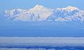
 Mount Spurr (L) and Mount Chichantna (R) Northeast aspect | |
| Highest point | |
| Elevation | 10,893 ft (3,320 m) [1] [2] |
| Prominence | 1,443 ft (440 m) [2] |
| Parent peak | Mount Spurr [2] |
| Isolation | 2.41 mi (3.88 km) [2] |
| Coordinates | 61°19′57″N152°16′23″W / 61.3325000°N 152.2730556°W [3] |
| Geography | |
 Mount Chichantna Location in Alaska | |
 | |
| Interactive map of Mount Chichantna | |
| Country | United States |
| State | Alaska |
| Borough | Kenai Peninsula |
| Parent range | Alaska Range Tordrillo Mountains [4] |
| Topo map | USGS Tyonek B-7 |
| Climbing | |
| Easiest route | Expedition climbing |
Mount Chichantna is a 10,893-foot-elevation (3,320-meter) mountain summit in Alaska.