
The Colorado Plateau is a physiographic and desert region of the Intermontane Plateaus, roughly centered on the Four Corners region of the southwestern United States. This plateau covers an area of 336,700 km2 (130,000 mi2) within western Colorado, northwestern New Mexico, southern and eastern Utah, northern Arizona, and a tiny fraction in the extreme southeast of Nevada. About 90% of the area is drained by the Colorado River and its main tributaries: the Green, San Juan, and Little Colorado. Most of the remainder of the plateau is drained by the Rio Grande and its tributaries.

Grove Karl Gilbert, known by the abbreviated name G. K. Gilbert in academic literature, was an American geologist.

The Henry Mountains is a mountain range located in the southeastern portion of the U.S. state of Utah that runs in a generally north-south direction, extending over a distance of about 30 miles (48 km). They were named by Almon Thompson in honor of Joseph Henry, the first secretary of the Smithsonian Institution. The nearest town of any size is Hanksville, Utah, which is north of the mountains. The Henry Mountains were the last mountain range to be added to the map of the 48 contiguous U.S. states (1872), and before their official naming by Thompson were sometimes referred to as the "Unknown Mountains." In Navajo, the range is still referred to as Dził Bizhiʼ Ádiní.

Mount Hillers is a summit in the Henry Mountains range, in Garfield County, Utah, in the United States. Its elevation is 10,741 feet (3,274 m) NAVD 88.

Mount Spry is a small 5,720-ft elevation mountain summit made of Navajo Sandstone located in Zion National Park, in Washington County of southwest Utah, United States. Officially named in 1934, it honors William Spry (1864–1929), the third governor of Utah. The nearest higher peak is The East Temple, 0.34 miles (0.55 km) to the east. Precipitation runoff from the mountain drains into tributaries of the North Fork Virgin River.

The East Temple is a prominent 7,709 feet (2,350 m) summit composed of Navajo Sandstone in Zion National Park, in Washington County of southwest Utah, United States. It is one of the notable landmarks in the park. The nearest neighbor is Twin Brothers, one-half mile to the north, and the nearest higher peak is The West Temple, 3.85 miles (6.20 km) to the west-southwest. The mountain is situated 1.8 miles northeast of the park headquarters, at the confluence of Pine Creek and the North Fork Virgin River. This feature's name was applied by John Wesley Powell during his explorations in 1872, and was officially adopted in 1934 by the U.S. Board on Geographic Names. The first ascent was made in 1937 by Glen Dawson, Dick Jones, Homer Fuller, Wayland Gilbert, and Jo Momyer.

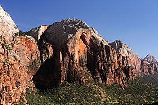
The Sentinel is a 7,120+ ft elevation Navajo Sandstone summit located near the Court of the Patriarchs in Zion National Park, in Washington County of southwest Utah, United States, that is part of the Towers of the Virgin. The national park map lists the elevation as 7,157-feet.

Cathedral Mountain is a 6,930-foot (2,110 m) elevation Navajo Sandstone summit located in Zion National Park, in Washington County of southwest Utah, United States.

Mountain of the Sun is a 6,722-foot (2,049 m) elevation Navajo Sandstone summit located in Zion National Park, in Washington County of southwest Utah, United States. Mountain of the Sun is situated immediately east of Court of the Patriarchs, and south of Zion Lodge, towering 2,500 feet above the lodge and the floor of Zion Canyon. It is set on the east side of the North Fork of the Virgin River which drains precipitation runoff from this mountain. Its neighbors include The Sentinel, Mount Spry, The East Temple, and Mount Moroni. This feature's name was officially adopted in 1934 by the U.S. Board on Geographic Names.
Red Arch Mountain is a 5,930-foot (1,810 m) elevation Navajo Sandstone summit located in Zion National Park, in Washington County of southwest Utah, United States.

Mount Majestic, also known as Majestic Mountain, is a 6,956-foot (2,120 m) elevation Navajo Sandstone double-summit mountain located in Zion National Park, in Washington County of southwest Utah, United States.

The Sundial is a 7,590-foot (2,310-meter) elevation white Navajo Sandstone summit located in Zion National Park, in Washington County of southwest Utah, United States.
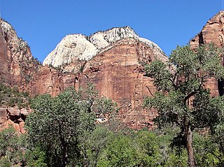
Castle Dome is a 7,054-foot (2,150 m) elevation Navajo Sandstone summit located in Zion National Park, in Washington County of southwest Utah, United States. Castle Dome is situated northwest of Zion Lodge, towering 2,800 feet (850 m) above the lodge and the floor of Zion Canyon. It is set on the west side of the North Fork Virgin River which drains precipitation runoff from this mountain. It is wedged between Behunin Canyon and Heaps Canyon, with the popular Emerald Pools set at the southeast foot of this mountain. Its neighbors include Mount Majestic, Cathedral Mountain, The Great White Throne, Red Arch Mountain, Mountain of the Sun, and Lady Mountain. This feature's name was officially adopted in 1934 by the U.S. Board on Geographic Names.

Mount Pennell is a prominent 11,413-foot elevation summit located in eastern Garfield County, Utah, United States. Mount Pennell is the second-highest mountain in the Henry Mountains, following Mount Ellen, 10.6 miles to the north. It is situated in a dry, rugged, and sparsely settled region east of Capitol Reef National Park, on primitive land administered by the Bureau of Land Management. Several deep canyons cut the sides of the mountain, which on the higher slopes supports oak, Ponderosa pine, subalpine fir, spruce, Douglas fir, and aspen. Precipitation runoff from this mountain drains into tributaries of the nearby Colorado River.

Bull Mountain is a 9,187-foot elevation summit located in northern Garfield County of Utah, United States. Bull Mountain is part of the Henry Mountains which are set between Capitol Reef National Park to the west, and Glen Canyon National Recreation Area to the east. Mount Ellen is immediately southwest of Bull Mountain, and Burr Desert spreads out to the northeast. It is situated in a dry, rugged, and sparsely settled region, set on primitive land administered by the Bureau of Land Management. Precipitation runoff from this mountain drains into tributaries of the Colorado River. The nearest town is Hanksville, 17 miles to the north, and Robbers Roost is 20 miles to the northeast.

Three Marys are three sandstone pillars in Zion National Park in Washington County, Utah, United States.

Mountain of Mystery is a 6,565-foot (2,001 m) Navajo Sandstone summit located in Zion National Park, in Washington County of southwest Utah, United States. Mountain of Mystery is situated above The Narrows, towering over 2,100 feet above the floor of Zion Canyon and the North Fork Virgin River which drains precipitation runoff from this mountain. This peak rises above Orderville Canyon on its north side, and Mystery Canyon on the south. Its neighbors include Mount Majestic, Cathedral Mountain, Observation Point, Cable Mountain, Angels Landing, and The Organ. This feature's name was officially adopted in 1934 by the U.S. Board on Geographic Names. The first ascent via the Northeast Buttress was made 15 September 2001, by Brian Cabe and Tom Jones.

Mount Ellsworth is an 8,235-foot elevation summit located in Garfield County, Utah, United States. Mount Ellsworth is part of the Henry Mountains. It is situated in a dry, rugged, and sparsely settled region west of Glen Canyon National Recreation Area, on primitive land administered by the Bureau of Land Management. Precipitation runoff from this mountain drains into tributaries of the nearby Colorado River, which here is Lake Powell eight miles to the east of this mountain.

Smithsonian Butte is a 6,780-foot (2,070 m) elevation summit located in the Canaan Mountain Wilderness of Washington County in southwest Utah, United States.

Split Mountain is a 7,657-foot-elevation (2,334-meter) summit in Uintah County, Utah, United States.


