Big Sky is an unincorporated community and census-designated place (CDP) in Gallatin and Madison counties in southwestern Montana, United States. As of the 2020 census, it had a population of 3,591, up from 2,308 in 2010. It is 44 miles (71 km) by road southwest of Bozeman. The primary industry of the area is tourism.

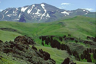
The Absaroka Range is a sub-range of the Rocky Mountains in the United States. The range stretches about 150 mi (240 km) across the Montana–Wyoming border, and 75 mi (120 km) at its widest, forming the eastern boundary of Yellowstone National Park along Paradise Valley, and the western side of the Bighorn Basin. The range borders the Beartooth Mountains to the north and the Wind River Range to the south. The northern edge of the range rests along I-90 and Livingston, Montana. The highest peak in the range is Francs Peak, located in Wyoming at 13,153 ft (4,009 m). There are 46 other peaks over 12,000 ft (3,700 m).
Shoshone National Forest is the first federally protected National Forest in the United States and covers nearly 2,500,000 acres (1,000,000 ha) in the state of Wyoming. Originally a part of the Yellowstone Timberland Reserve, the forest is managed by the United States Forest Service and was created by an act of Congress and signed into law by U.S. President Benjamin Harrison in 1891. Shoshone National Forest is one of the first nationally protected land areas anywhere. Native Americans have lived in the region for at least 10,000 years, and when the region was first explored by European adventurers, forestlands were occupied by several different tribes. Never heavily settled or exploited, the forest has retained most of its wildness. Shoshone National Forest is a part of the Greater Yellowstone Ecosystem, a nearly unbroken expanse of federally protected lands encompassing an estimated 20,000,000 acres (8,100,000 ha).

Mount Washburn, elevation 10,219 feet (3,115 m), is a prominent mountain peak in the Washburn Range in Yellowstone National Park, Wyoming, United States. The peak was named in 1870 to honor Henry D. Washburn, leader of the Washburn–Langford–Doane Expedition. The Washburn Range is one of two mountains ranges completely within the boundaries of Yellowstone.

Electric Peak is the tallest mountain in the Gallatin Range of southern Montana, close to the Wyoming border and rising to an altitude of 10,969 feet (3,343 m). The peak has some of the greatest physical relief in Yellowstone National Park, rising 3,389 ft (1,033 m) above its base.
Gray Peak el. 10,298 feet (3,139 m) is a prominent mountain peak in the Gallatin Range in the remote northwest section of Yellowstone National Park, Wyoming. The peak is approximately 9.1 miles (14.6 km) west-southwest of Mammoth Hot Springs and 8.9 miles (14.3 km) north of Mount Holmes. There are no maintained trails to the summit. The closest maintained trail is the Fawn Pass Trail which skirts the southern face approximately 1 mile (1.6 km) south of the peak.

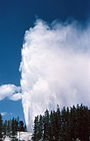
Yellowstone National Park has over 1,100 miles (1,800 km) of blazed and mapped hiking trails, including some that have been in use for hundreds of years. Several of these trails were the sites of historical events. Yellowstone's trails are noted for various geysers, hot springs, and other geothermal features, and for viewing of bald eagles, ospreys, grizzly bears, black bears, wolves, coyotes, bighorn sheep, pronghorns, and free-ranging herds of bison and elk.

Eagle Peak is a mountain in the Absaroka Range in the U.S. state of Wyoming and at 11,372 feet (3,466 m) is the highest point in Yellowstone National Park. It is located about 6 miles (9.7 km) east of the southeast arm of Yellowstone Lake.

Union Pass is a high mountain pass in the Wind River Range in Fremont County of western Wyoming in the United States. The pass is located on the Continental Divide between the Gros Ventre mountains on the west and the Wind River Range on the east. A triple divide exists nearby, where water may flow to the Mississippi River, Columbia River, or Colorado River. The pass was historically used by Native Americans and early mountain men including the Astor Expedition in 1811 on its way west. On the return trip, fearing hostile Indian activity near Union Pass, the Astorians chose a southern route and discovered South Pass.

The following articles relate to the history, geography, geology, flora, fauna, structures and recreation in Yellowstone National Park.

Mount Sheridan, elevation 10,313 feet (3,143 m), is a prominent mountain peak overlooking Heart Lake in the Red Mountains of Yellowstone National Park. The peak is named in honor of General Philip H. Sheridan, U.S. Army, one of the early protectors of the park.
Antler Peak, el. 10,063 feet (3,067 m) is a prominent mountain peak in the Gallatin Range in Yellowstone National Park. The peak was originally named Bell's Peak in honor of an Assistant Secretary of the Interior by either Philetus Norris, the second park superintendent or W.H.Holmes, a U.S. Geological Survey geologist in 1878. However, in 1885, Arnold Hague of the U.S. Geological Survey renamed the peak Antler Peak because of the numerous shed elk and deer antlers found on its slopes.

Mount Jackson el. 8,231 feet (2,509 m) is a mountain peak just north of the Madison River, in the Gallatin Range of Yellowstone National Park. Mount Jackson is named in honor of William Henry Jackson, chief photographer of the Hayden Geological Survey of 1871 and a member of several subsequent geological surveys in the park. Jackson's photographs are some of the earliest ever taken in Yellowstone. The name was suggested by a park naturalist in 1935 but not awarded until 1937 when Jackson, who was still living gave his approval. Jackson visited the park regularly until his death in 1942.
Mount Chittenden, elevation 10,182 feet (3,103 m), is a mountain peak in the Absaroka Range in Yellowstone National Park. The peak was named by Henry Gannett of the Hayden Geological Survey of 1878 for George B. Chittenden, a surveyor who had worked with Gannett, Hayden and others in surveys in Montana, Idaho and Wyoming. Chittenden never participated in any of the Yellowstone surveys.

Clagett Butte el. 8,041 feet (2,451 m) is a mountain peak butte in the Gallatin Range in Yellowstone National Park. Clagett Butte is an isolated summit 1.9 miles (3.1 km) west of Mammoth Hot Springs between Clematis Creek and Snow Pass. The Snow Pass trail passes approximately .33 miles (0.53 km) south of the butte.

Terrace Mountain is a mountain peak in the Gallatin Range in Yellowstone National Park in Park County, Wyoming, United States. The mountain is located 2.2 miles (3.5 km) southwest of Mammoth Hot Springs. Terrace Mountain was named by the 1878 Hayden Geological Survey because of its proximity to the travertine terraces at Mammoth and because it too is an ancient travertine terrace. The mountain has also been known as "Soda Mountain" and "White Mountain".

There are nine named plateaus in Yellowstone National Park. These plateaus are part of the much larger Yellowstone Plateau and dominate areas in the park south and west of the Gallatin and Absaroka mountain ranges. Four of the plateaus are from rhyolite lava flows that occurred between 110,000 and 70,000 years ago.

Purple Mountain, elevation 8,392 feet (2,558 m), is a mountain peak in the southern section of the Gallatin Range in Yellowstone National Park, in the U.S. state of Montana. The Purple Mountain Trail ascends to the summit from Madison Junction. It is located near the Lava Creek Tuff.

Three Rivers Peak is a 9,958-foot (3,035 m) mountain summit in the southern section of the Gallatin Range in Yellowstone National Park, in the U.S. state of Wyoming.
Amethyst Mountain, el. 9,609 feet (2,929 m) is the highest peak and central part of a northwest – southeast trending ridge that lies between the Lamar River to the northeast and Deep Creek to the southwest within Park County, Wyoming. From northwest to southeast, this ridge consists of Specimen Ridge, Amethyst Mountain, and the Mirror Plateau in Yellowstone National Park. The nearest town is Silver Gate, Montana, which is 19.2 miles away.
 Mount Holmes' namesake, William H. Holmes
 Mount Holmes as seen from Winter Creek, 1890
 Mount Holmes and other peaks, 1963
 Looking east from summit of Mount Holmes, 1965
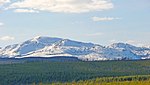 2009
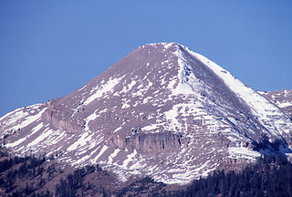
2009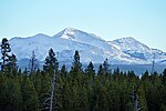 Mount Holmes (center) from Madison River, October 2010