The Yellowstone Caldera is a volcanic caldera and supervolcano in Yellowstone National Park in the Western United States, sometimes referred to as the Yellowstone Supervolcano. The caldera and most of the park are located in the northwest corner of Wyoming. The major features of the caldera measure about 34 by 45 miles.
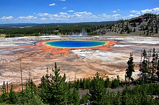
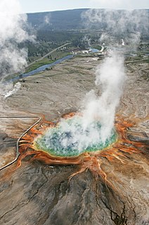
The Grand Prismatic Spring in Yellowstone National Park is the largest hot spring in the United States, and the third largest in the world, after Frying Pan Lake in New Zealand and Boiling Lake in Dominica. It is located in the Midway Geyser Basin.

Emerald Spring is a hot spring located in Norris Geyser Basin of Yellowstone National Park.

Fishing Cone is a geyser in the West Thumb Geyser Basin of Yellowstone National Park in the United States.

Beauty Pool is a hot spring in the Upper Geyser Basin of Yellowstone National Park in the United States.
Beryl Spring is a hot spring in the Gibbon Geyser Basin of Yellowstone National Park in the United States. It is a large superheated pool, and boils up to a height of 4 feet.
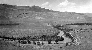
The Shoshone River is a 100-mile (160 km) long river in northern Wyoming in the United States. Its headwaters are in the Absaroka Range in Shoshone National Forest. It ends when it runs into the Big Horn River near Lovell, Wyoming. Cities it runs near or through are Cody, Powell, Byron, and Lovell. Near Cody, it runs through a volcanically active region of fumaroles known as Colter's Hell. This contributed to the river being named on old maps of Wyoming as the Stinking Water River.

Mystic Falls is a 70-foot (21 m) cascade type waterfall on the Little Firehole River, a tributary of the Firehole River. Originally named Little Firehole Falls by members of the 1872 Hayden Geologic Survey, the name was changed to Mystic Falls by members of the Arnold Hague Geological Survey in 1885 for unknown reasons.

The Gardner River is a tributary of the Yellowstone River, approximately 25 miles (40 km) long, in northwestern Wyoming and south central Montana in the United States. The entire river is located within Yellowstone National Park. It rises on the slope of Joseph Peak, Gallatin Range in the northwestern part of the park, and winds southeast through Gardner's Hole, a broad subalpine basin which is a popular trout fishing location. Angling on the Gardner is governed by Yellowstone National Park fishing regulations. After merging with Panther Creek, Indian Creek and Obsidian Creek, it then turns north and flows through a steep canyon where it cuts through a basaltic flow from approximately 500,000 years ago known as Sheepeater Cliffs. Below Sheepeater, Glen Creek out of Golden Gate Canyon and Lava Creek out of Lava Creek Canyon join the Gardner near Mammoth Hot Springs. The river crosses the 45th parallel in Gardner Canyon and is also home to a popular hot spring known as The Boiling River. The river continues north through Gardner Canyon and empties into the Yellowstone near Gardiner, Montana.

The following articles relate to the history, geography, geology, flora, fauna, structures and recreation in Yellowstone National Park.
Sepulcher Mountain el. 9,642 feet (2,939 m) is a moderate mountain peak in northwest Yellowstone National Park halfway between the summit of Electric Peak and Mammoth Hot Springs. The peak was named Sepulcher by Captain John W. Barlow, U.S. Army in 1871 because of its resemblance to a crypt when viewed from Gardiner, Montana.
Bunsen Peak el. 8,564 feet (2,610 m) is a prominent peak due south of Mammoth Hot Springs in Yellowstone National Park, Wyoming. The peak lies on the east flank of Kingman Pass on the Mammoth to Norris section of the Grand Loop Road. The peak was first ascended by Ferdinand V. Hayden and Captain John W. Barlow in 1871, Bunsen Peak was not named until 1872 during the second Hayden Geologic Survey. E. S. Topping named the peak Observation Mountain in 1872 as well, but that name did not stick. The Bunsen Peak Trail with its trailhead just south of Mammoth is a steep 2.1 miles (3.4 km) to the summit. Bunsen Peak was named for the German chemist Robert Bunsen, the inventor of the Bunsen Burner and responsible for early work on volcanic geyser theories.

Shoshone Lake is a U.S. backcountry lake with the area of 8,050 acres elevated at 7,795 feet (2,376 m) in the southwest section of Yellowstone National Park, Wyoming. It lies at the headwaters of the Lewis River a tributary of the Snake River. The U.S. Fish and Wildlife Service believes that Shoshone Lake is the largest backcountry lake in the lower 48 states that cannot be reached by a road.

Barlow Peak el. 9,609 feet (2,929 m) is an isolated mountain peak in the Big Game Ridge section of southwest Yellowstone National Park south of the Continental Divide. Barlow peak was named by geologist Arnold Hague in 1885 for Captain John W. Barlow an early topographical engineer mapping in the park.

Dunraven Peak el. 9,869 feet (3,008 m) is a mountain peak in the Washburn Range of Yellowstone National Park. In 1874, just two years after the park's creation, the Earl of Dunraven, a titled Englishman made a visit to Yellowstone in conjunction with a hunting expedition led by Texas Jack Omohundro to the Northern Rockies. He was so impressed with the park, that he devoted well over 150 pages to Yellowstone in his The Great Divide, published in London in 1874. The Great Divide was one of the earliest works to praise and publicize the park.

Clagett Butte el. 8,041 feet (2,451 m) is a mountain peak butte in the Gallatin Range in Yellowstone National Park. Clagett Butte is an isolated summit 1.9 miles (3.1 km) west of Mammoth Hot Springs between Clematis Creek and Snow Pass. The Snow Pass trail passes approximately .33 miles (0.53 km) south of the butte.

Terrace Mountain is a mountain peak in the Gallatin Range in Yellowstone National Park, Wyoming, United States. The mountain is located 2.2 miles (3.5 km) southwest of Mammoth Hot Springs. Terrace Mountain was named by the 1878 Hayden Geological Survey because of its proximity to the travertine terraces at Mammoth and because it too is an ancient travertine terrace. The mountain has also been known as "Soda Mountain" and "White Mountain".

Fall River rises on the Madison and Pitchstone plateaus in the southwest corner of Yellowstone National Park, Wyoming and flows approximately 64 miles (103 km) to its confluence with the Henrys Fork of the Snake River near Ashton, Idaho. Historically, the river was referred to as the Middle Fork of the Snake River or as Fall River or the Falls River by trappers and prospectors as early as the 1830s. It was officially named the Falls River by the 1872 Hayden Geological Survey, but was always called Fall River by the locals and so the U.S. Board on Geographic Names changed the official name to Fall River in 1997 at the request of Idaho authorities. The river is home to numerous waterfalls and cascades in its upper reaches.

Mount Hancock el. 10,223 feet (3,116 m) is an isolated mountain peak on Big Game Ridge in Yellowstone National Park. Captain John W. Barlow named the peak in honor of General Winfield Scott Hancock during the Barlow-Heap Exploration of Yellowstone in 1871. General Hancock is noted for issuing the orders that established the military escort led by Lt. Gustavus Cheyney Doane for the Washburn–Langford–Doane Expedition of 1870.