Grand Teton National Park is an American national park in northwestern Wyoming. At approximately 310,000 acres (1,300 km2), the park includes the major peaks of the 40-mile-long (64 km) Teton Range as well as most of the northern sections of the valley known as Jackson Hole. Grand Teton National Park is only 10 miles (16 km) south of Yellowstone National Park, to which it is connected by the National Park Service–managed John D. Rockefeller Jr. Memorial Parkway. Along with surrounding national forests, these three protected areas constitute the almost 18-million-acre (73,000-square-kilometer) Greater Yellowstone Ecosystem, one of the world's largest intact mid-latitude temperate ecosystems.

Longs Peak is a high and prominent mountain in the northern Front Range of the Rocky Mountains of North America. The 14,259-foot (4346 m) fourteener is located in the Rocky Mountain National Park Wilderness, 9.6 miles (15.5 km) southwest by south of the Town of Estes Park, Colorado, United States. Longs Peak is the northernmost fourteener in the Rocky Mountains of Colorado and the highest point in Boulder County and Rocky Mountain National Park. The mountain was named in honor of explorer Stephen Harriman Long and is featured on the Colorado state quarter.

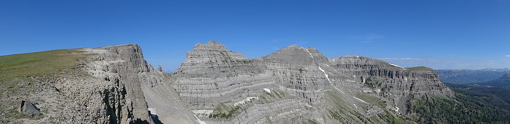
The Absaroka Range is a sub-range of the Rocky Mountains in the United States. The range stretches about 150 mi (240 km) across the Montana–Wyoming border, and 75 mi (120 km) at its widest, forming the eastern boundary of Yellowstone National Park along Paradise Valley, and the western side of the Bighorn Basin. The range borders the Beartooth Mountains to the north and the Wind River Range to the south. The northern edge of the range rests along I-90 and Livingston, Montana. The highest peak in the range is Francs Peak, located in Wyoming at 13,153 ft (4,009 m). There are 46 other peaks over 12,000 ft (3,700 m).

The Wind River Range is a mountain range of the Rocky Mountains in western Wyoming in the United States. The range runs roughly NW–SE for approximately 100 mi (160 km). The Continental Divide follows the crest of the range and includes Gannett Peak, which at 13,802 ft (4,207 m), is the highest peak in Wyoming; and also Fremont Peak at 13,750 ft (4,191 m), the third highest peak in Wyoming. There are more than 40 other named peaks in excess of 12,999 ft (3,962 m). With the exception of the Grand Teton in the Teton Range, the next 19 highest peaks in Wyoming after Gannett are also in the Winds.

Grand Teton is the highest mountain in Grand Teton National Park, in Northwest Wyoming, and a classic destination in American mountaineering.

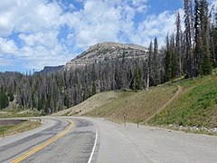
Togwotee Pass is a high mountain pass in the western United States, at an elevation of 9,655 feet (2,943 m) above sea level. On the Continental Divide in the Absaroka Mountains of northwestern Wyoming in Teton County, it is between Dubois and Moran Junction in the Jackson Hole valley.
Shoshone National Forest is the first federally protected National Forest in the United States and covers nearly 2,500,000 acres (1,000,000 ha) in the state of Wyoming. Originally a part of the Yellowstone Timberland Reserve, the forest is managed by the United States Forest Service and was created by an act of Congress and signed into law by U.S. President Benjamin Harrison in 1891. Shoshone National Forest is one of the first nationally protected land areas anywhere. Native Americans have lived in the region for at least 10,000 years, and when the region was first explored by European adventurers, forestlands were occupied by several different tribes. Never heavily settled or exploited, the forest has retained most of its wildness. Shoshone National Forest is a part of the Greater Yellowstone Ecosystem, a nearly unbroken expanse of federally protected lands encompassing an estimated 20,000,000 acres (8,100,000 ha).

Quandary Peak is the highest summit of the Tenmile Range in the Rocky Mountains of North America and is the most commonly climbed fourteener in Colorado. It has nearly the same elevation as Castle Peak and Mount Blue Sky. It lies in Summit County and within the White River National Forest about 6 miles (10 km) south-southwest of the town of Breckenridge.

Frozen Head State Park and Natural Area is a state park in Morgan County, Tennessee, in the southeastern United States. The park, situated in the Crab Orchard Mountains between the city of Wartburg and the community of Petros, contains some of the highest mountains in Tennessee west of the Blue Ridge.

The Weminuche Wilderness is a wilderness area in southwest Colorado managed by the United States Forest Service as part of the San Juan National Forest on the west side of the Continental Divide and the Rio Grande National Forest on the east side of the divide. The Weminuche Wilderness was designated by Congress in 1975, and expanded by the Colorado Wilderness Acts of 1980 and 1993. It is located 4 miles (6.4 km) southeast of the town of Silverton, 17 miles (27 km) northeast of Durango, and 8 miles (13 km) west of South Fork. At 499,771 acres (2,022.50 km2), it is the largest wilderness area in the state of Colorado. Elevation in the wilderness ranges from 7,700 feet (2,300 m) along the Animas River to 14,093 feet (4,296 m) at the summit of Windom Peak.

West Spanish Peak is a high and prominent mountain summit that is the higher of the two Spanish Peaks in the Rocky Mountains of North America. The prominent 13,631-foot (4,155 m) peak is located in the Spanish Peaks Wilderness of San Isabel National Forest, 9.1 miles (14.7 km) south of the Town of La Veta, Colorado, United States, on the drainage divide between Huerfano and Las Animas counties. The summit of West Spanish Peak is the highest point in Las Animas County, Colorado.

Rusk Mountain is a peak located in the towns of Jewett and Lexington in Greene County, New York, United States. At 3,680 feet (1,120 m) in elevation, it is the 20th-highest peak in the Catskill Mountains and considered a member of the Catskill High Peaks. While there is no maintained trail, a bushwhack to the summit is considered relatively easy, and required for membership in the Catskill Mountain 3500 Club.

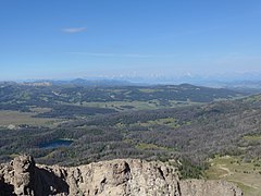
Eagle Peak is a mountain in the Absaroka Range in the U.S. state of Wyoming and at 11,372 feet (3,466 m) is the highest point in Yellowstone National Park. It is located about 6 miles (9.7 km) east of the southeast arm of Yellowstone Lake.

The Sugarland Mountain Trail is an American hiking trail, in the Great Smoky Mountains National Park of Sevier County, Tennessee. The trail traverses Sugarland Mountain, a massive ridge running perpendicular to the main crest of the Smokies and effectively dividing the park's north-central section from its northwestern section. Sugarland Mountain is flanked by the deep upper valleys of two of the park's major watersheds— the West Fork of the Little Pigeon River and Little River. The trail passes through several forest types, including deciduous forest at lower elevations, heaths ("hells") along the mountain's backbone formations, and a stand of Southern Appalachian spruce-fir forest in the upper elevations. Occasional breaks in the foliage allow for views of Mount Le Conte and Sevier County to the east and Blanket Mountain and the ridges above Elkmont to the west.

The Snake Den Ridge Trail is an American hiking trail in the Great Smoky Mountains National Park of Cocke County, Tennessee. Winding its way up the backbone-like crest of Snake Den Ridge, the trail connects the Cosby Campground to the Appalachian Trail and provides the quickest access to the high peaks of the Eastern Smokies. The trail passes through three forest types— a mixed deciduous forest at its lower elevations, a substantial stand of heath bald on the more narrow sections of the ridge crest, and an old growth northern-style coniferous forest at its higher elevations.

The Thunderer el. 10,558 feet (3,218 m) is a mountain peak in the northeast section of Yellowstone National Park, in the Absaroka Range of the U.S. state of Wyoming. Named by members of the Arnold Hague Geological Survey of 1885 for its propensity to attract thunderstorms, the mountain is a long high ridge just north of Mount Norris. Prior to 1885, the peak was merely considered a high ridge extending north from Mount Norris rather than a separately named peak. The Thunderer is easily visible from the northeast entrance road as it passes up the Soda Butte Creek canyon.

The Garnet Canyon Trail is a 4.8-mile (7.7 km) long hiking trail in Grand Teton National Park in the U.S. state of Wyoming. The trailhead is at the Lupine Meadows parking area and climbs steeply more than 2,500 feet (760 m) in just under 5 miles (8.0 km) into Garnet Canyon. At the 2-mile (3.2 km) point, the trail forks from the Amphitheater Lake Trail and heads south and then west into Garnet Canyon. Garnet Canyon is the most popular approach route for climbers attempting to summit not only Grand Teton but also Middle Teton, South Teton, Teepe Pillar and Disappointment Peak. Though the trail becomes unmaintained once it enters boulder fields at approximately the 9,500-foot (2,900 m) elevation point, climbers continue on to other destinations such as the Lower Saddle, a high altitude mountain pass situated between Middle and Grand Teton. The altitude gain from the Lupine Meadows trailhead to the Lower Saddle is nearly 5,000 feet (1,500 m).
Poke-O-Moonshine Mountain, spelled Pokamoonshine on U.S. Geological Survey maps, and sometimes known as just Poke-O, is a minor peak of the Adirondack Mountains. The name is believed to be a corruption of the Algonquin words pohqui, meaning 'broken', and moosie, meaning 'smooth'. It is located in the town of Chesterfield, New York, United States, on New York state Forest Preserve land, part of the Taylor Pond Wild Forest complex within the Adirondack Park. Due to its location next to the pass through which most travelers from the north enter the range, it has been called the "gateway to the Adirondacks".

Two Ocean Mountain is a 10,724-foot-elevation (3,269-meter) summit in Teton County, Wyoming, United States.