Wilkins Peak

Last updated
Wilkins Peak
Wilkinspeakscottsbottom.jpg
Wilkins Peak
Highest point
Elevation 7,650 ft (2,330 m)
Coordinates 41°29′47.44″N109°20′45.15″W / 41.4965111°N 109.3458750°W / 41.4965111; -109.3458750 [1]
Geography
Climbing
Easiest route Access Road
The remains of the KUWZ tower still present in 2005 Kuwzremains.jpg
The remains of the KUWZ tower still present in 2005

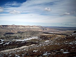
Wilkins Peak is a small mountain located in Sweetwater County, Wyoming, between the cities of Green River and Rock Springs. It is primarily used for radio and television station transmitters, but it also serves radio needs of the FAA, EMS, and local businesses such as Questar Gas. In 2003, a tower on the peak was knocked down by a vehicle delivering propane to customers. The tower was owned by Wyoming Public Radio and was serving the local area with programming from National Public Radio. There are numerous access roads to the peak and it is not gated and open year-round, weather permitting. Along with the radio uses, the mountain is also a popular location for mountain biking and hiking. The mountain contains geology typical of its location in southwestern Wyoming.

Contents

Geology

Along with other mountains in southwestern Wyoming, Wilkins Peak is part of the Green River Formation, a formation of the intermontane Lake Gosiute environment during the Eocene epoch. Similar to its neighboring Aspen Mountain, Wilkins Peak is part of the Rock Springs Uplift, [2] and some of the largest oil shale and trona beds in the region are located near the mountain. Wilkins Peak also has its own distinct segment of the Green River Formation, which is known as the Wilkins Peak Member . [3] [4] The peak itself is 7,650 feet (2,332 m) in elevation and is located 8.18 miles (13 km) from Rock Springs, Wyoming and 6.3 miles (10 km) from Green River, Wyoming.

Radio and television uses

Wilkins Peak holds radio towers for several FM radio and television stations. Stations include KYCS (95.1 FM) and its sister stations KFRZ (92.1 FM) and KZWB (97.9 FM). Also on the mountain is the tower for the station KTME 89.5, which signed on the air in September 2010. KTME is an affiliate of Pilgrim Radio. The transmitter for KREO 93.5 is also on the peak. KLWR 101.9 FM, and KAWR 98.7 are also on Wilkins Peak, and carry programming from K-Love and Air1 repsectively. Several television translators transmit or have transmitted their signals from two small towers located in the center of Wilkins Peak. The religious television network TBN had a translator known as K35CN, broadcasting from the mountain. [5] Prior to 2009, K22BK, the local PBS television translator, carried its signal from Wilkins Peak. K22BK was moved across the interstate to White Mountain to the same tower as its digital counterpart (K28JU-D). [6] In late 2009, a new television station signed on the air from the peak. It was known as K33IX-D on channel 33 (UHF) and carried programming from IBN Television. The station is currently off air. [7] K35CN and K22BK have been off the air since the digital television transition in the year 2009.

FM translators

Among high powered FM radio stations, Wilkins Peak is also currently host lower powered FM translators. K205FE carries a Gospel format on 88.9 FM. K232CU rebroadcasts KLWR on 94.3 FM, and K285FG retransmits programming from AM station KUGR on 104.9 FM. [8] [9] [10]

Wilkins Peak also has repeater towers for local police, fire, and EMS services. The emergency radio repeaters on the mountain are used in conjunction with other repeaters located on nearby Aspen Mountain and Mansface Hill. [11]

In September 2003, a commercial truck delivering propane to customers on the peak knocked down the then-existent KUWZ tower after the vehicle's brakes failed. The collapse of the tower knocked out power to the mountain for several hours, and while KUWZ borrowed space from neighboring towers for several months thereafter, the station ultimately relocated its transmitter to nearby Aspen Mountain. [12] [13]

Accessing the peak

Wilkins Peak is not gated, and it can be reached via an unpaved road known as Wilkins Peak Road that starts on U.S. Route 191 southwest of Rock Springs, Wyoming. The mountain can also be accessed via another unpaved road that begins in the Scott's Bottom Nature Area in Green River, Wyoming. The peak is accessible year-round, weather permitting. The Green River access road is in worse shape than the Rock Springs side, and it has several road hazards such as steep grades, poor grading, and off-road vehicle traffic. Along with serving radio needs, the peak also is a popular hiking and mountain biking location in the area. There are many smaller roads and trails that spring from the peak that offer varied degrees of challenge. [14] [15]

Trail system

The Sweetwater Mountain Bike Association, a committee of the City of Green River Chamber of Commerce and in partnership with the BLM, U.S. Forest Service and Rock Springs Grazing Association has sanctioned the mountain biking trail system known as the Wilkins Peak Trail System, currently a group of single track trails encompassing just over 24 miles located on land directly west of Wilkins Peak. Accessed primarily from the Green River area these trails offer a mix of varying difficulty levels for every rider. Current trail maps can be obtained for free at the Green River Chamber of Commerce at the Visitor Center.

See also

Related Research Articles

<span class="mw-page-title-main">Sweat Mountain</span>

Sweat Mountain is a mountain in far northeastern Cobb County, Georgia, in the suburbs north of Atlanta. The exact GNIS location of its summit is 34°4′1″N84°27′20″W, and it has an official (USGS) elevation of 1,688 ft (515 m) above mean sea level. It is the second-highest point in the county behind Kennesaw Mountain, and second in the core metro Atlanta area, behind Kennesaw Mountain, which is also in Cobb County. It is fifth if the exurban counties further north are considered.

<span class="mw-page-title-main">Casper Mountain</span> Mountain in Wyoming, United States

Casper Mountain, an anticline, is located at the north end of the Laramie Mountains overlooking Casper, Wyoming along the North Platte River. At a top elevation of 8,130 feet (2,478 m), the geological feature rises approximately 3,000 feet (914 m) above Casper.

WMIT is a non-profit FM radio station licensed to Black Mountain, North Carolina. WMIT is a listener-supported ministry of the Billy Graham Evangelistic Association. It airs a mix of Contemporary Christian music with some Christian talk and teaching programs, including national religious leaders Jim Daly, John MacArthur, David Jeremiah, Chuck Swindoll and Charles Stanley. Studios and offices are on Porters Cove Road in Asheville. WMIT's tower rises 180 feet (55 m) above 6,557-foot (1,999 m) Clingman's Dome.

<span class="mw-page-title-main">Broadcast relay station</span> Repeater transmitter

A broadcast relay station, also known as a satellite station, relay transmitter, broadcast translator (U.S.), re-broadcaster (Canada), repeater or complementary station (Mexico), is a broadcast transmitter which repeats the signal of a radio or television station to an area not covered by the originating station. It expands the broadcast range of a television or radio station beyond the primary signal's original coverage or improves service in the original coverage area. The stations may be used to create a single-frequency network. They may also be used by an AM or FM radio station to establish a presence on the other band.

<span class="mw-page-title-main">KRKK</span> Radio station in Rock Springs, Wyoming

KRKK is a commercial AM radio station broadcasting from Rock Springs, Wyoming on 1360 kHz. KRKK broadcasts from two towers near its studios on Yellowstone Road in Rock Springs, Wyoming and is owned by Big Thicket Broadcasting Company of Wyoming. The current programming format is oldies under the branding Unforgettable Memories.

<span class="mw-page-title-main">KZWB</span> Radio station in Green River, Wyoming

KZWB is a radio station broadcasting from Green River, Wyoming. The station signed on June 1, 2005. KZWB is owned by Wagonwheel Communications Corporation, who also owns KUGR and KZWB's two sister stations KYCS and KFRZ.

<span class="mw-page-title-main">KYCS</span> Radio station in Rock Springs, Wyoming

KYCS is a hot adult contemporary station broadcasting from Rock Springs, Wyoming.

<span class="mw-page-title-main">KFRZ</span> Radio station in Green River, Wyoming

KFRZ is a radio station broadcasting from Green River, Wyoming, serving southwestern Wyoming. Broadcasting a country music format, the station is part of The Radio Network, which includes sister stations KUGR, KYCS, and KZWB. KFRZ broadcasts satellite fed music from Westwood One formerly the Jones Radio Network. Like its sister stations, KFRZ has local news throughout the day, and sports highlights as well. The station is currently owned by Wagonwheel Communications Corp.

<span class="mw-page-title-main">KQSW</span> Radio station in Rock Springs, Wyoming

KQSW is a country music formatted radio station broadcasting from Rock Springs, Wyoming, serving southwestern Wyoming. The station is owned by Big Thicket Broadcasting of Wyoming, who identifies themselves as WyoRadio, which includes local sister stations KSIT, KMRZ-FM, and KRKK.

Pilgrim Radio is a network of radio stations broadcasting a Christian Radio format. Pilgrim Radio's programming includes interviews with Christian leaders, discussion of current events/issues, news, a book-reading program, and Biblically based teaching messages, along with Christian Contemporary music. Pilgrim Radio is listener-supported and commercial-free.

<span class="mw-page-title-main">Mansface Hill</span>

Mansface Hill is a mountain located in Green River, Wyoming. The mountain is named for its rock outcroppings, which form the shape of a face looking up into the sky.

Aspen Mountain is a long mountain located approximately 12 miles (19 km) south of Rock Springs, Wyoming and 5.5 miles (8.9 km) south of Arrowhead Springs, in Sweetwater County. The mountain gets its name from patches of Quaking Aspen trees located on the north and southern faces of the mountain. Various older topographical maps name the mountain "Quaking Aspen Mountain". Its primary use is for radio communications and it houses towers for various local and state companies.

<span class="mw-page-title-main">Farnsworth Peak</span> Mountain in Utah, United States

Farnsworth Peak is a peak located on the northern end of the Oquirrh Mountain range, approximately 3.5 miles (6 km) south east of Lake Point, Utah and 18 miles (29 km) south west of Salt Lake City, Utah, United States. The mountain is named for Philo Farnsworth, the inventor of the first completely electronic television. It is used mainly for radio and television transmission, but could potentially become part of a ski resort owned by nearby Kennecott Land. On the eastern side of the mountain, the land is completely private, and access is restricted. The peak can be reached by hiking from the Tooele side, which is mostly public land. The Bureau of Land Management land extends from Ridge Peak west to the base of the mountain. Public access to this land is available off SR-36 near Lake Point, Utah. Several cattle gates need to be opened and closed, but are access roads to hiking, mountain biking, and horseback riding areas.

<span class="mw-page-title-main">White Mountain (Wyoming)</span>

White Mountain is a long mountain located in central Sweetwater County, Wyoming, near the cities of Rock Springs and Green River. The mountain is part of the Green River Formation, and contains communications towers that serve a number of purposes. Hundreds of carved figures also dot the sandstone cliffs at the White Mountain Petroglyph site and range from 200 to 1000 years old. Pilot Butte, located on top of White Mountain, is accessible from roads on the mountain.

<span class="mw-page-title-main">Medicine Butte</span>

Medicine Butte is a mountain located in Uinta County, approximately 6.9 miles (11 km) north of the city of Evanston, Wyoming. It is 8,610 feet (2,624 m) in elevation and can be reached via an access road. The mountain houses radio towers serving numerous local and regional services.

KZUW is a classical music radio station licensed to Reliance, Wyoming. The station is owned and operated by the University of Wyoming.

<span class="mw-page-title-main">Humpy Peak</span> Mountain in Utah, United States

Humpy Peak is a peak located in the Uinta Mountain Range in northern Utah. It is approximately 27.56 miles (44 km) south of Evanston, Wyoming and 21.29 miles (34 km) east of Coalville, Utah. The summit has an elevation of 10,875 feet (3,315 m).

<span class="mw-page-title-main">Lake Mountains</span>

The Lake Mountains are a 15-mile-long (24 km) mountain range located on the western edge of the Utah Valley in northwestern Utah County, Utah, United States. The range forms the northwest border of Utah Lake, and its proximity to major population centers allows its use for communication towers, mostly in its north section, bordering Eagle Mountain.

<span class="mw-page-title-main">KREO (FM)</span> Radio station in James Town, Wyoming

KREO is an American radio station licensed to serve the community of James Town, Wyoming.

<span class="mw-page-title-main">Sawtell Peak</span> Mountain in Idaho, United States

Sawtell Peak, also spelled Sawtelle Peak is a mountain in the U.S. state of Idaho. It is located in the eastern portion of the Centennial Mountains. Sawtell Peak is located in the Caribou-Targhee National Forest roughly 1.3 miles (2.1 km) east of Idaho's border with Montana.

References

  1. "Wilkins Peak USGS Wilkins Peak Quad, Wyoming, Topographic Map". United States Geological Survey. Retrieved 2008-07-05.
  2. Alan Caroll: Green River, Department of Geology & Geophysics, University of Wisconsin-Madison
  3. Eugster, H.P.; Hardie, L.A. (1975). "Sedimentation in an ancient playa-lake complex; the Wilkins Peak Member of the Green River Formation of Wyoming". Bulletin of the Geological Society of America. 86 (3): 319–334. Bibcode:1975GSAB...86..319E. doi:10.1130/0016-7606(1975)86<319:SIAAPC>2.0.CO;2. ISSN   0016-7606 . Retrieved 2008-04-20.
  4. "Green River Formation". University of California Museum of Paleontology. Retrieved 2008-04-19.
  5. "Rock Springs FCC TV Query". Federal Communications Commission. Retrieved 2008-04-18.
  6. Rock Springs AM and FM Market - RTLI
  7. "RabbitEars.Info".
  8. K285FG
  9. K205FE
  10. K232CU
  11. "WY Public Safety Mobile Communications Steering Committee Meeting" (PDF). State of Wyoming, Wyolink. 2002-12-20. Retrieved 2008-04-18.
  12. Kathy Gilbert (2003-09-17). "Local WPR has bad gas" (txt). The Green River Star. Retrieved 2008-04-18.
  13. "Wilkins Peak Radio Tower Information and Pictures". Ubstudios.com. Retrieved 2008-04-18.
  14. Wade Liedtke. "Wilkins Peak Trail" . Retrieved 2008-04-18.
  15. Wade Liedtke. "Ridgeline Trail" . Retrieved 2008-04-18.

http://grchamber.com/pages/MountainBikingInformation/