This page is based on this
Wikipedia article Text is available under the
CC BY-SA 4.0 license; additional terms may apply.
Images, videos and audio are available under their respective licenses.

Bridger-Teton National Forest is located in western Wyoming, United States. The forest consists of 3.4 million acres (14,000 km2), making it the third largest National Forest outside Alaska. The forest stretches from Yellowstone National Park, along the eastern boundary of Grand Teton National Park and from there rides along the western slope of the Continental Divide to the southern end of the Wind River Range. The forest also extends southward encompassing the Salt River Range and Wyoming Range mountains near the Idaho border.

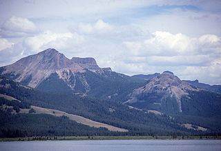
Mount Washburn, elevation 10,243 feet (3,122 m), is a prominent mountain peak in the Washburn Range in Yellowstone National Park, Wyoming. The peak was named in 1870 to honor Henry D. Washburn, leader of the Washburn–Langford–Doane Expedition. The Washburn Range is one of two mountains ranges completely within the boundaries of Yellowstone.

Eagle Peak is a mountain in the Absaroka Range in the U.S. state of Wyoming and at 11,372 feet (3,466 m) is the highest point in Yellowstone National Park. It is located about 6 miles (9.7 km) east of the southeast arm of Yellowstone Lake.

Mount Holmes is a prominent mountain peak in Yellowstone National Park. It is the tallest mountain in the Wyoming portion of the Gallatin Range. Mount Holmes is located in the northwestern part of the park and marks the southern terminus of the Gallatin Range. It is the source of Indian Creek, a tributary of the Gardner River.

The following articles relate to the history, geography, geology, flora, fauna, structures and recreation in Yellowstone National Park.

Mount Sheridan el. 10,313 feet (3,143 m) is a prominent mountain peak overlooking Heart Lake in the Red Mountains of Yellowstone National Park. The peak is named in honor of General Philip H. Sheridan, U.S. Army, one of the early protectors of the park.

Mount Doane el. 10,551 feet (3,216 m) is a mountain peak in the Absaroka Range in Yellowstone National Park. The peak is named for Lieutenant Gustavus Cheyney Doane, a U.S. Army cavalry officer who escorted the Washburn-Langford-Doane Expedition into Yellowstone in 1870. During that expedition, Doane and Nathaniel P. Langford ascended several peaks east of Yellowstone Lake.
Colter Peak el. 10,640 feet (3,240 m) is a mountain peak in the Absaroka Range in the southeastern section of Yellowstone National Park. The peak is named for mountain man John Colter, reputedly the first white man to visit the Yellowstone region. Colter Peak was first ascended in 1870 by Lt. Gustavus Cheyney Doane and Nathaniel P. Langford during the Washburn–Langford–Doane Expedition. Henry D. Washburn, the expedition leader named the peak for Langford and Doane. For unknown reasons, geologist Ferdinand V. Hayden moved those names to peaks farther north in 1871 during the Hayden Geological Survey of 1871. In 1888, Philetus Norris the second park superintendent, named the peak Mount Forum for unknown reasons. In 1885, geologist Arnold Hague gave the peak its official name: Colter Peak.

Fall River rises on the Madison and Pitchstone plateaus in the southwest corner of Yellowstone National Park, Wyoming and flows approximately 64 miles (103 km) to its confluence with the Henrys Fork of the Snake River near Ashton, Idaho. Historically, the river was referred to as the Middle Fork of the Snake River or as Fall River or the Falls River by trappers and prospectors as early as the 1830s. It was officially named the Falls River by the 1872 Hayden Geological Survey, but was always called Fall River by the locals and so the U.S. Board on Geographic Names changed the official name to Fall River in 1997 at the request of Idaho authorities. The river is home to numerous waterfalls and cascades in its upper reaches.

Trischman Knob el. 8,573 feet (2,613 m) is an isolated summit along the Continental Divide on the Madison Plateau in Yellowstone National Park. The summit is located approximately 1.5 miles (2.4 km) west of the Bechler River trail just south of Madison Lake, the source of the Firehole River. The summit was named in 1962 by Assistant Chief Ranger Willam S. Chapman for Harry Trischman (1886–1950). Trischman came to Yellowstone in 1899 with his parents. His father was the post carpenter at Fort Yellowstone. Trischman worked as a U.S. Army scout and in 1916 became one of the first park rangers. He worked as a ranger in Yellowstone until his retirement in 1945. Trischman Knob was one of his favorite backcountry haunts.

Druid Peak is a moderate domed peak on the southern flank of the Absaroka Range in Yellowstone National Park. The peak lies just north of the Lamar River and Soda Butte Creek confluence at the head of the Lamar Valley. Prior to 1885, this summit was named Soda Hill by members of the Hayden Geological Survey of 1878 and Mount Longfellow or Longfellows' Peak by then park superintendent Philetus Norris in 1880. In 1885, members of the Arnold Hague Geological Survey changed the name to Druid Peak for unknown reasons, but some historians believe it may have been the presence of Stonehenge like rock formations on its eastern face that prompted the name.
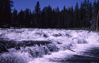
Bechler Falls ht. 15 feet (4.6 m) is a waterfall on the Bechler River in Yellowstone National Park. Bechler Falls is the last waterfall on the Bechler River and is approximately 1 mile (1.6 km) from the confluence with the Fall River. It can be reached via the Bechler River trail approximately 3.5 miles (5.6 km) from the Cave Falls trailhead at the south boundary of the park. The falls were named in 1921 by explorers E. C. Gregg and C.H. Birdseye.

Iris Falls is a waterfall on the Bechler River in Yellowstone National Park. Iris Falls is located just upstream from Colonnade Falls and is accessible via the Bechler River Trail. The falls were named in 1885 by members of the Arnold Hague Geological Survey for Iris, the mythological Greek goddess of the rainbow.
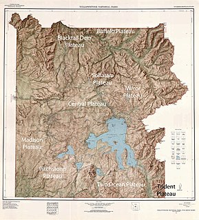
There are nine named plateaus in Yellowstone National Park. These plateaus are part of the much larger Yellowstone Plateau and dominate areas in the park south and west of the Gallatin and Absaroka mountain ranges. Four of the plateaus are from rhyolite lava flows that occurred between 110,000 and 70,000 years ago.

Colonnade Falls ht. upper 35 feet (11 m), ht. lower 67 feet (20 m) is a set of two waterfalls on the Bechler River in Yellowstone National Park. Colonnade Falls is accessible via the Bechler River Trail. The falls were named in 1885 by members of the Arnold Hague Geological Survey probably because the falls resemble a row of columns at regular intervals.


