Bechler River

Last updated
Map all coordinates using: OpenStreetMap
Bechler River
BelcherRiver1964.jpg
Bechler River
Physical characteristics
Source 
  location Trischman Knob
  coordinates 44°17′21″N110°53′35″W / 44.28917°N 110.89306°W / 44.28917; -110.89306 (Belcher River source) [1]
  elevation6,306 feet (1,922 m) [1]
Mouth  
  location
Fall River
  coordinates
44°08′54″N110°59′49″W / 44.14833°N 110.99694°W / 44.14833; -110.99694 (Bechler River mouth) [1]
Basin features
Tributaries 
  leftFerris Fork, Littler Fork
  rightBoundary Creek, Ouzel Creek, Phillips Fork, Gregg Fork

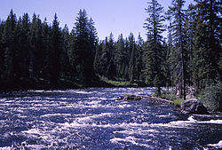
The Bechler River is a remote major river flowing southwest entirely within the confines of Yellowstone National Park to its confluence with the Fall River in the southwest section of the park. The river was named by Frank Bradley, a member of the 1872 Hayden Geological Survey for cartographer and explorer Gustavus R. Bechler, the chief surveyor and mapmaker on the survey. Henry Gannett also a member of the survey claimed that Bechler discovered the river, but trapper Osborne Russell explored the area in 1830. [2]

Contents

Waterfalls

The Bechler River is located in the remote southwest part of the park known as Cascade Corner, named by Superintendent Horace Albright in 1921 for the abundance of waterfalls and cascades in the Fall and Bechler River drainages. Several major Yellowstone waterfalls exist in the Bechler River watershed: [3]

Angling

Although the Bechler River is in the remote Cascade Corner of the park, it is popular with local anglers. It holds mostly cutthroat trout and a few rainbow trout. Because of spring runoff, the river is generally not fishable until mid-July and access is difficult. [16] [17] The river is paralleled by the Bechler River Trail which starts at Cave Falls on the park's south boundary or spurs off the Shoshone Lake trail.

Notes

  1. 1 2 3 "Bechler River". Geographic Names Information System . United States Geological Survey, United States Department of the Interior.
  2. Whittlesey, Lee (1996). Yellowstone Place Names. Wonderland Publishing Company Gardiner, MT. p. 47. ISBN   1-59971-716-6.
  3. Whittlesey, Lee (1996). Yellowstone Place Names. Wonderland Publishing Company Gardiner, MT. pp. 61–62. ISBN   1-59971-716-6.
  4. "Albright Falls". Geographic Names Information System . United States Geological Survey, United States Department of the Interior.
  5. "Bechler River". Geographic Names Information System . United States Geological Survey, United States Department of the Interior.
  6. "Colonnade Falls". Geographic Names Information System . United States Geological Survey, United States Department of the Interior.
  7. "Dunanda Falls". Geographic Names Information System . United States Geological Survey, United States Department of the Interior.
  8. "Gwinna Falls". Geographic Names Information System . United States Geological Survey, United States Department of the Interior.
  9. "Iris Falls". Geographic Names Information System . United States Geological Survey, United States Department of the Interior.
  10. "Ouzel Falls". Geographic Names Information System . United States Geological Survey, United States Department of the Interior.
  11. "Quiver Cascade". Geographic Names Information System . United States Geological Survey, United States Department of the Interior.
  12. "Ragged Falls". Geographic Names Information System . United States Geological Survey, United States Department of the Interior.
  13. "Tempe Cascade". Geographic Names Information System . United States Geological Survey, United States Department of the Interior.
  14. "Twister Falls". Geographic Names Information System . United States Geological Survey, United States Department of the Interior.
  15. "Wahhi Falls". Geographic Names Information System . United States Geological Survey, United States Department of the Interior.
  16. Parks, Richard (1998). Fishing Yellowstone National Park. Helena, MT: Falcon Press. ISBN   1-56044-625-0.
  17. Mathews, Craig; Molinero, Clayton (1997). The Yellowstone Fly-Fishing Guide—An authoritative guide to the waters of Yellowstone National Park. Guilford, CT: The Lyons Press. ISBN   1-55821-545-X.


Related Research Articles

<span class="mw-page-title-main">Fall River (Wyoming, Idaho)</span> River in Idaho, United States

Fall River rises on the Madison and Pitchstone Plateaus in the southwest corner of Yellowstone National Park, Wyoming and flows approximately 64 miles (103 km) to its confluence with the Henrys Fork of the Snake River near Ashton, Idaho. Historically, the river was referred to as the Middle Fork of the Snake River or as Fall River or the Falls River by trappers and prospectors as early as the 1830s. It was officially named the Falls River by 1872 Hayden Geological Survey, but was always called Fall River by the locals and so the U.S. Board on Geographic Names changed the official name to Fall River in 1997 at the request of Idaho authorities. The river is home to numerous waterfalls and cascades in its upper reaches.

<span class="mw-page-title-main">Bechler Falls</span> Waterfall in Teton County, Wyoming

Bechler Falls ht. 15 feet (4.6 m) is a waterfall on the Bechler River in Yellowstone National Park. Bechler Falls is the last waterfall on the Bechler River and is approximately 1 mile (1.6 km) from the confluence with the Fall River. It can be reached via the Bechler River trail approximately 3.5 miles (5.6 km) from the Cave Falls trailhead at the south boundary of the park. The falls were named in 1921 by explorers E. C. Gregg and C.H. Birdseye.

<span class="mw-page-title-main">Iris Falls</span> Waterfall in Teton County, Wyoming

Iris Falls is a waterfall on the Bechler River in Yellowstone National Park. Iris Falls is located just upstream from Colonnade Falls and is accessible via the Bechler River Trail. The falls were named in 1885 by members of the Arnold Hague Geological Survey for Iris, the mythological Greek goddess of the rainbow.

<span class="mw-page-title-main">Plateaus of Yellowstone National Park</span>

There are nine named plateaus in Yellowstone National Park. These plateaus are part of the much larger Yellowstone Plateau and dominate areas in the park south and west of the Gallatin and Absaroka mountain ranges. Four of the plateaus are from rhyolite lava flows that occurred between 110,000 and 70,000 years ago.

<span class="mw-page-title-main">Nez Perce in Yellowstone Park</span>

The Nez Perce native Americans fled through Yellowstone National Park between August 20 and Sept 7, during the Nez Perce War in 1877. As the U.S. army pursued the Nez Perce through the park, a number of hostile and sometimes deadly encounters between park visitors and the Indians occurred. Eventually, the army's pursuit forced the Nez Perce off the Yellowstone plateau and into forces arrayed to capture or destroy them when they emerged from the mountains of Yellowstone onto the valley of Clark's Fork of the Yellowstone River.

Square Butte is a name used for 11 buttes in Montana. Two of the most prominent buttes are located in a) Cascade County, Montana, about 22 miles (35 km) due west of Great Falls and in b) Chouteau County, Montana, about 50 miles (80 km) due east of Great Falls and about 15 miles (24 km) due east of the Highwood Mountains. Charles Marion Russell, the noted Montana western artist used both features as background in his paintings of Montana.