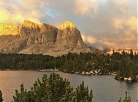
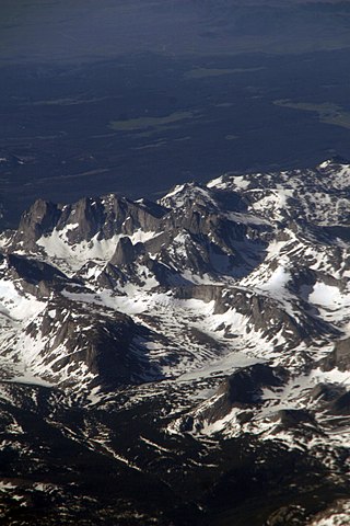
Lizard Head Peak is in the southern Wind River Range in the U.S. state of Wyoming. Situated in Shoshone National Forest, Lizard Head Peak is the northeasternmost peak in the Cirque of the Towers, a popular climbing area. Lizard Head Glacier is just WNW of the peak.

Mount Warren is located in the Wind River Range in the U.S. state of Wyoming. The peak is the third peak in the range and the fourth tallest in Wyoming. The summit is located in the Fitzpatrick Wilderness of Shoshone National Forest and rises above several glaciers, the best known being Dinwoody Glacier which is immediately north of the summit tower. The mountain abuts, but is not within, either Bridger National Forest or Sublette County, Wyoming.
Turret Peak is the sixth-highest peak in the U.S. state of Wyoming and the fifth-highest in the Wind River Range. The Dinwoody Glacier is located on the northwest slope of the mountain, while the Helen Glacier is to the south. Turret Peak is estimated to be between 13,606 to 13,646 feet high.

Jackson Peak 13,523 feet (4,122 m) is the eighth-highest peak in the U.S. state of Wyoming and the seventh-highest in the Wind River Range. The Bull Lake Glacier is located immediately north and east of the mountain. Situated on the Continental Divide, Jackson Peak is .75 miles (1.21 km) southeast of Fremont Peak.
Bastion Peak, at 13,500 feet (4,100 m), is located in the Wind River Range in the U.S. state of Wyoming. The peak is the ninth-highest in the range and the tenth-highest in Wyoming. The summit is located on the Continental Divide and the eastern slopes of the mountain are covered by a section of Gannett Glacier, the largest glacier in the American Rocky Mountains. An arête to the northeast leads to Bastion Peak-Northeast Peak, which, at 13,476 ft (4,107 m), is also one of the highest points in Wyoming.

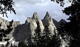
Pingora Peak is a prominent granite peak in the U.S. state of Wyoming. The peak is one of the pinnacles that forms the Cirque of the Towers. Pingora Peak is in the Popo Agie Wilderness and part of the Wind River Range within the greater Shoshone National Forest. The Northeast Face route on Pingora Peak is recognized in the historic climbing text Fifty Classic Climbs of North America and considered a classic around the world.
Sunbeam Peak is located in the Wind River Range in the U.S. state of Wyoming. The peak is the 13th highest summit in Wyoming. The summit is located in Shoshone National Forest and the Heap Steep Glacier lies on the north slopes of the mountain.

Union Peak is located in the northern Wind River Range in the U.S. state of Wyoming. Union Peak straddles the Continental Divide and is in both Bridger-Teton and Shoshone National Forests. Union Pass is 4.5 mi (7.2 km) NW of Union Peak.
Rampart Peak is located in the northern Wind River Range in the U.S. state of Wyoming. Situated .31 mi (0.50 km) south of Bastion Peak, Rampart Peak is within the Bridger Wilderness of Bridger-Teton National Forest and immediately west of the Continental Divide. Though one of the highest peaks in the Wind River Range, Rampart Peak is not ranked since it has less than 300 ft (91 m) of clean topographic prominence.
American Legion Peak is located in the northern Wind River Range in the U.S. state of Wyoming. Situated 1 mi (1.6 km) east of Bow Mountain and a couple miles west of Mount Helen, American Legion Peak is the 17th tallest peak in Wyoming. The small American Legion Glacier descends from the east slopes of the mountain and Henderson Peak lies to the south.
Harrower Peak is located in the northern Wind River Range in the U.S. state of Wyoming, and it is the 28th tallest mountain in the state. Harrower Peak is in the Bridger Wilderness of Bridger-Teton National Forest and the Harrower Glacier is less than .50 mi (0.80 km) northeast of the peak.

Split Mountain is located in the Wind River Range in the U.S. state of Wyoming. Split Mountain is the 22nd highest peak in Wyoming. Split Mountain is in the Bridger Wilderness of Bridger-Teton National Forest and is about .70 mi (1.13 km) northwest of Twin Peaks and 1 mi (1.6 km) southeast of Mount Whitecap. Mammoth Glacier is on the northeast slopes of the peak while the smaller Baby Glacier flows down from a spur to the northwest.
Bair Peak is located in the Wind River Range in the U.S. state of Wyoming. The mountain is on the Continental Divide in the Bridger Wilderness of Bridger-Teton National Forest and Popo Agie Wilderness of Shoshone National Forest. Washakie Glacier lies on the north slopes of the peak.

Temple Peak is located in the southern Wind River Range in the U.S. state of Wyoming. Temple Peak is a little over 1 mile (1.6 km) southwest of East Temple Peak. Temple Peak is in the Bridger Wilderness of Bridger-Teton National Forest.

Mitchell Peak is located in the southern Wind River Range in the U.S. state of Wyoming. Mitchell Peak is on the southern side of the Cirque of the Towers, a popular climbing area. Mitchell Peak sits along the Continental Divide, less than 1 mi (1.6 km) northwest of Dog Tooth Peak. The peak was named after Finis Mitchell a respected forester and mountain climber of the Wind River Range. In recognition of his many accomplishments, the U.S. Congress named the peak after Mitchell while he was still living.
Warrior Peaks is located in the southern Wind River Range in the U.S. state of Wyoming. Warrior Peaks is on the southern side of the Cirque of the Towers, a popular climbing area and is just west of War Bonnet Peak. Warrior Peaks sits along the Continental Divide.
Pylon Peak is located in the southern Wind River Range in the U.S. state of Wyoming. Pylon Peak is on the west side of the Cirque of the Towers, a popular climbing area, and is .70 mi (1.13 km) northwest of Warrior Peaks. Pylon Peak sits along the Continental Divide.
Overhanging Tower is a mountain located in the southern Wind River Range in the U.S. state of Wyoming. Overhanging Tower is on the west side of the Cirque of the Towers, a popular climbing area. The peak is just north of Sharks Nose and south of the peak known as Wolfs Head. Overhanging Tower is situated on the Continental Divide.

Cathedral Peak is a mountain located in the southern Wind River Range in the U.S. state of Wyoming. Cathedral Peak is 1.5 mi (2.4 km) southwest of Mount Chauvenet in the Popo Agie Wilderness of Shoshone National Forest.
Mount Chauvenet is a mountain located in the southern Wind River Range in the U.S. state of Wyoming. Mount Chauvenet is 1.5 mi (2.4 km) northeast of Cathedral Peak in the Popo Agie Wilderness of Shoshone National Forest. Mount Chauvenet was one of the earliest peaks climbed by white explorers to the Wind River Range.