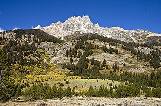
Mount Owen is the second highest peak in the Teton Range, Grand Teton National Park in the U.S. state of Wyoming. The peak is named after William O. Owen, who organized the first documented ascent of the Grand Teton in 1898. Mount Owen is part of the Cathedral Group of high Teton peaks, a collection of peaks in the central section of the range that are particularly rugged. The 40-mile (64 km) long Teton Range is the youngest mountain chain in the Rocky Mountains, and began its uplift 9 million years ago, during the Miocene. Several periods of glaciation have carved Mount Owen and the other peaks of the range into their current shapes. Valhalla Canyon is situated on the west slopes of Mount Owen.

Middle Teton is the third highest peak in the Teton Range, Grand Teton National Park, Wyoming. The peak is immediately southwest of Grand Teton and the two are separated from one another by the lower saddle, a broad high ridge at 11,600 feet (3,540 m). The Middle Teton Glacier is located on the eastern slopes of the peak. Middle Teton is a classic pyramidal shaped alpine peak and is sometimes included as part of the Cathedral Group of high Teton peaks. The 40-mile (64 km) long Teton Range is the youngest mountain chain in the Rocky Mountains, and began their uplift 9 million years ago, during the Miocene. Several periods of glaciation have carved Middle Teton and the other peaks of the range into their current shapes. From the lower saddle, a distinctive feature known as the black dike appears as a straight line running from near the top of the mountain down 800 feet (240 m). The black dike is a basaltic intrusion that occurred long after the surrounding rock was formed.
Teewinot Mountain is the sixth highest peak in the Teton Range, Grand Teton National Park, Wyoming. The name of the mountain is derived from the Shoshone Native American word meaning "many pinnacles". The peak is northeast of the Grand Teton, and the two are separated from one another by the Teton Glacier and Mount Owen. Teewinot Mountain rises more than 5,500 feet (1,700 m) above Jenny Lake. The 40 miles (64 km) long Teton Range is the youngest mountain chain in the Rocky Mountains, and began their uplift 9 million years ago, during the Miocene. Several periods of glaciation have carved Teewinot Mountain and the other peaks of the range into their current shapes. Broken Falls is one of the tallest cascades in Grand Teton National Park and descends 300 feet (91 m) down the eastern slopes of Teewinot Mountain.

South Teton is the fifth-highest peak in the Teton Range, Grand Teton National Park, in the U.S. state of Wyoming. The peak is south of Middle Teton and just west of Cloudveil Dome and is part of the Cathedral Group of high Teton peaks. The 40-mile-long (64 km) Teton Range is the youngest mountain chain in the Rocky Mountains, and began their uplift 9 million years ago, during the Miocene. Several periods of glaciation have carved South Teton and the other peaks of the range into their current shapes.

Eagles Rest Peak is in the northern Teton Range, Grand Teton National Park, Wyoming. The peak is located west of and across Jackson Lake from Colter Bay Village. The peak rises dramatically almost 4,500 feet (1,400 m) above Jackson Lake in less than 1 mile (1.6 km). Waterfalls Canyon is to the north of the peak and Snowshoe Canyon lies to the south.

Bivouac Peak is in the northern Teton Range, Grand Teton National Park, Wyoming. The peak is located immediately to the west of Moran Bay on Jackson Lake, and rises more than 4,000 ft (1,200 m) in less than 0.5 mi (0.80 km) from the lakeshore. Moran Canyon is situated to the south of the mountain and Snowshoe Canyon lies to the north.

Thor Peak is in the northern Teton Range, Grand Teton National Park, in the U.S. state of Wyoming. Mount Moran is 1 mile (1.6 km) to the east. The summit is the eighth-highest in the Teton Range. Several semi-permanent snowfields as well as the Triple Glaciers are located on the east and northern slopes of the mountain. While the easiest route up the mountain, the south slope, is only rated a class 4, the mountain's remoteness and difficulty of approach make it a challenging mountain to summit.

Disappointment Peak is in the Teton Range of Wyoming, in Grand Teton National Park and immediately southeast of Grand Teton. The peak is part of the Cathedral Group, a region of the Tetons noted for particularly rugged mountains. Disappointment Peak rises to the north of Garnet Canyon and to the west of Amphitheater and Surprise lakes. The peak has a variety of mountaineering routes, including the most difficult in the range.

Cloudveil Dome is located in the Teton Range, Grand Teton National Park, Wyoming, immediately southeast of Grand Teton. The peak is in the central portions of the range, immediately east of South Teton and is sometimes considered to be part of what is collectively known as the Cathedral Group. Cloudveil Dome rises to the south of Garnet Canyon. The peak has a variety of mountaineering routes but since it is near to more popular climbing zones, it is often overlooked.

Nez Perce Peak is located in the Teton Range, Grand Teton National Park, Wyoming, immediately southeast of Grand Teton. The peak is in the central portions of the range, immediately east of Cloudveil Dome and is sometimes considered to be part of what is collectively known as the Cathedral Group. Nez Perce rises to the south of Garnet Canyon and is a dramatic peak that dominates the skyline to the west of Bradley and Taggart Lakes. When viewed from the western section of Jackson Hole, Nez Perce often obscures the view of Cloudveil Dome as well as South Teton, even though both summits are higher.

Static Peak is located in the Teton Range, Grand Teton National Park, in the U.S. state of Wyoming. Located .48 miles (0.77 km) southeast of Buck Mountain, the summit is also east of the Alaska Basin Trail, from a point known as Static Peak Divide, the summit can be climbed in a scramble. Below the summit on the north face, a small remnant glacier persists, sheltered from direct sunlight by steep cliffs. Timberline Lake lies to the north of the peak.
Rendezvous Peak is in the Teton Range in the U.S. state of Wyoming. Situated just south of Grand Teton National Park and within Bridger-Teton National Forest, Rendezvous Peak is the highest point on Rendezvous Mountain.
Survey Peak is located in the northern Teton Range in the U.S. state of Wyoming. The peak is on the border of Grand Teton National Park and the Jedediah Smith Wilderness of Caribou-Targhee National Forest. Survey Peak rises to the immediate north of Berry Creek and can be accessed via the Berry Creek Trail.
Window Peak is located in the Teton Range, Grand Teton National Park in the U.S. state of Wyoming. The peak is in the western reaches of Moran Canyon.
Cleaver Peak (11,060 feet is located in the Teton Range, Grand Teton National Park in the U.S. state of Wyoming. Cleaver Peak is .64 miles to the NNE of Maidenform Peak. Cirque Lake is immediately east of the peak.
Maidenform Peak (11,142 feet is located in the Teton Range, Grand Teton National Park in the U.S. state of Wyoming. Maidenform Peak is at the head of Leigh Canyon and .64 miles SSW of Cleaver Peak. Cirque Lake is immediately east of the peak.
The Wall is located in the Teton Range in the U.S. state of Wyoming, running for more than 4 miles (6.4 km) along the western border of Grand Teton National Park. The peak is on the border of Grand Teton National Park and the Jedediah Smith Wilderness of Caribou-Targhee National Forest. This high point, near the northern terminus of the cliff, is 1 mile (1.6 km) WSW of South Teton and overlooks Snowdrift Lake.
Veiled Peak is located in the Teton Range, within Grand Teton National Park, U.S. state of Wyoming. Veiled Peak is west of Mount Wister and rises to the south above Snowdrift Lake.

Mount Hunt (10,788 feet is located in the Teton Range, Grand Teton National Park in the U.S. state of Wyoming. The peak is situated near the head of Open Canyon and just west of Mount Hunt Divide. The peak was named after William Price Hunt, one of the leaders of the 1811-12 Astor Expedition.
Spearhead Peak is located in the Teton Range, Caribou-Targhee National Forest in the U.S. state of Wyoming. The peak is situated near the head of Death Canyon and the Teton Crest Trail is immediately west of the peak.