
Mount Warren is located in the Wind River Range in the U.S. state of Wyoming. The peak is the third peak in the range and the fourth tallest in Wyoming. The summit is located in the Fitzpatrick Wilderness of Shoshone National Forest and rises above several glaciers, the best known being Dinwoody Glacier which is immediately north of the summit tower. The mountain abuts, but is not within, either Bridger National Forest or Sublette County, Wyoming.

Mount Helen is located in the Wind River Range in the U.S. state of Wyoming. The peak is the fourth highest peak in the range and the fifth tallest in Wyoming. The summit is located in the Bridger Wilderness of Bridger-Teton National Forest, immediately west of the Continental Divide. The eastern flanks of the mountain are covered in snowfields and glaciers, including Helen and Sacagawea Glaciers, all of which are in the Fitzpatrick Wilderness of Shoshone National Forest.
Doublet Peak is the sixth-highest peak in the U.S. state of Wyoming and the fifth-highest in the Wind River Range. The summit is immediately south of Dinwoody Glacier and just west of Mount Warren.
Mount Sacagawea is the eighth-highest peak in the U.S. state of Wyoming and the seventh-highest in the Wind River Range. It was named after Sacagawea, the young Lemhi Shoshone woman who accompanied the Lewis and Clark Expedition as an interpreter and guide. The Upper Fremont Glacier is located southeast and the Sacagawea Glacier is northeast of the mountain. Straddling the Continental Divide, Mount Sacagawea is one mile (1.6 km) northwest of Fremont Peak.

Jackson Peak 13,523 feet (4,122 m) is the eighth-highest peak in the U.S. state of Wyoming and the seventh-highest in the Wind River Range. The Bull Lake Glacier is located immediately north and east of the mountain. Situated on the Continental Divide, Jackson Peak is .75 miles (1.21 km) southeast of Fremont Peak.
Mount Woodrow Wilson is located in the Wind River Range in the U.S. state of Wyoming. Mount Woodrow Wilson is the eighth-highest mountain in the range and the ninth-highest in Wyoming. The summit is located in the Bridger Wilderness of Bridger-Teton National Forest on the Continental Divide, 1.25 miles (2.01 km) south of Gannett Peak. The flanks of the mountain are covered in snowfields and glaciers, including Dinwoody Glacier to the northeast, Mammoth Glacier to the west and Sphinx Glacier to the south.
Bastion Peak, at 13,500 feet (4,100 m), is located in the Wind River Range in the U.S. state of Wyoming. The peak is the ninth-highest in the range and the tenth-highest in Wyoming. The summit is located on the Continental Divide and the eastern slopes of the mountain are covered by a section of Gannett Glacier, the largest glacier in the American Rocky Mountains. An arête to the northeast leads to Bastion Peak-Northeast Peak, which, at 13,476 ft (4,107 m), is also one of the highest points in Wyoming.
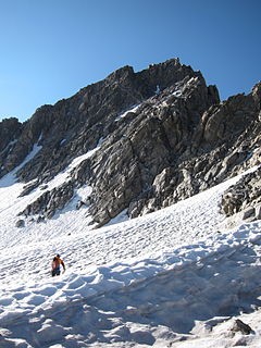
Sunbeam Peak is located in the Wind River Range in the U.S. state of Wyoming. The peak is the 13th highest summit in Wyoming. The summit is located in Shoshone National Forest and the Heap Steep Glacier lies on the north slopes of the mountain.
Downs Mountain is located in the Wind River Range in the U.S. state of Wyoming. Downs Mountain is the 15th highest peak in Wyoming. The summit is on the Continental Divide in both Shoshone and Bridger-Teton National Forests. The East Torrey Glacier is on the northern slopes of Downs Mountain, while Continental Glacier lies to the west and north and the Downs Glacier is 1 mi (1.6 km) to the south.
Rampart Peak is located in the northern Wind River Range in the U.S. state of Wyoming. Situated .31 mi (0.50 km) south of Bastion Peak, Rampart Peak is within the Bridger Wilderness of Bridger-Teton National Forest and immediately west of the Continental Divide. Though one of the highest peaks in the Wind River Range, Rampart Peak is not ranked since it has less than 300 ft (91 m) of clean topographic prominence.

Klondike Peak is located in the northern Wind River Range in the U.S. state of Wyoming. Situated 4 mi (6.4 km) north of Gannett Peak, Klondike Peak is within the Bridger Wilderness of Bridger-Teton National Forest and west of the Continental Divide. The summit of Klondike Peak is partially capped by a small glacier and the northwest flank of the peak is the origination point of J Glacier, while Sourdough Glacier lies just to the northeast. Klondike Peak is the 26th tallest peak in Wyoming.
Knife Point Mountain is located in the northern Wind River Range in the U.S. state of Wyoming. Situated 2.7 mi (4.3 km) southeast of Fremont Peak, Knife Point Mountain is on the Continental Divide. North of Knife Point Mountain is the origination point of Knife Point Glacier, while Harrower Glacier lies just to the west. Knife Point Mountain is the 32nd tallest peak in Wyoming.
Mount Whitecap is located in the northern Wind River Range in the U.S. state of Wyoming. Situated 2.25 mi (3.62 km) southwest of Gannett Peak, Mount Whitecap is in the Bridger Wilderness of Bridger-Teton National Forest. Baby Glacier lies just to the east of the peak and Split Mountain is 1 mi (1.6 km) southeast. Mount Whitecap is the 30th tallest peak in Wyoming.
Bow Mountain is located in the northern Wind River Range in the U.S. state of Wyoming. Situated 1 mi (1.6 km) west of American Legion Peak, Bow Mountain is in the Bridger Wilderness of Bridger-Teton National Forest. Stroud Glacier lies just to the north of the peak. Bow Mountain is the 29th tallest peak in Wyoming.
American Legion Peak is located in the northern Wind River Range in the U.S. state of Wyoming. Situated 1 mi (1.6 km) east of Bow Mountain and a couple miles west of Mount Helen, American Legion Peak is the 17th tallest peak in Wyoming. The small American Legion Glacier descends from the east slopes of the mountain and Henderson Peak lies to the south.
Harrower Peak is located in the northern Wind River Range in the U.S. state of Wyoming, and it is the 28th tallest mountain in the state. Harrower Peak is in the Bridger Wilderness of Bridger-Teton National Forest and the Harrower Glacier is less than .50 mi (0.80 km) northeast of the peak.
Mount Koven is located in the Wind River Range in the U.S. state of Wyoming. Mount Koven is the 16th highest peak in Wyoming. The summit is on the Continental Divide in both Shoshone and Bridger-Teton National Forests and it is .75 mi (1.21 km) north-northwest of Gannett Peak. The Gannett Glacier flanks the peak to the east, while Minor Glacier is just southwest of the mountain.
Twin Peaks is located in the Wind River Range in the U.S. state of Wyoming. Twin Peaks is the 20th highest peak in Wyoming. Twin Peaks is in the Bridger Wilderness of Bridger-Teton National Forest and is .58 mi (0.93 km) southwest of Mount Woodrow Wilson and about the same distance southeast of Split Mountain. Mammoth Glacier flows from the north slopes of the peak while the smaller Twins Glacier flows to the southeast.
Split Mountain is located in the Wind River Range in the U.S. state of Wyoming. Split Mountain is the 22nd highest peak in Wyoming. Split Mountain is in the Bridger Wilderness of Bridger-Teton National Forest and is about .70 mi (1.13 km) northwest of Twin Peaks and 1 mi (1.6 km) southeast of Mount Whitecap. Mammoth Glacier is on the northeast slopes of the peak while the smaller Baby Glacier flows down from a spur to the northwest.
Bastion Peak-Northeast Peak 13,476 ft (4,107 m) is located in the Wind River Range in the U.S. state of Wyoming. The peak is one of the highest in Wyoming, and is connected to its taller neighbor Bastion Peak by an arête to the southwest. An unnamed glacier lies below the precipitous east flank of the mountain, while Gannett Glacier is to the south.


