
The Wind River Range is a mountain range of the Rocky Mountains in western Wyoming in the United States. The range runs roughly NW–SE for approximately 100 mi (160 km). The Continental Divide follows the crest of the range and includes Gannett Peak, which at 13,802 ft (4,207 m), is the highest peak in Wyoming; and also Fremont Peak at 13,750 ft (4,191 m), the third highest peak in Wyoming. There are more than 40 other named peaks in excess of 12,999 ft (3,962 m). With the exception of the Grand Teton in the Teton Range, the next 19 highest peaks in Wyoming after Gannett are also in the Winds.

Gannett Peak is the highest mountain peak in the U.S. state of Wyoming at 13,810 feet (4,210 m). It lies in the Wind River Range within the Bridger Wilderness of the Bridger-Teton National Forest. Straddling the Continental Divide along the boundary between Fremont and Sublette counties, it has the second greatest topographic prominence in the state (7076') after Cloud Peak (7077'), and is the highest ground for 290.36 miles in any direction.

Gannett Glacier is the largest glacier in the Rocky Mountains within the United States. The glacier is located on the east and north slopes of Gannett Peak, the highest mountain in Wyoming, on the east side of the Continental Divide in the Wind River Range. Gannett is but one of dozens of glaciers located in the Fitzpatrick Wilderness of Shoshone National Forest.

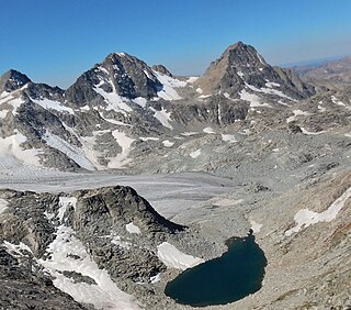
Mount Warren is located in the Wind River Range in the U.S. state of Wyoming. The peak is the third peak in the range and the fourth tallest in Wyoming. The summit is located in the Fitzpatrick Wilderness of Shoshone National Forest and rises above several glaciers, the best known being Dinwoody Glacier which is immediately north of the summit tower. The mountain abuts, but is not within, either Bridger National Forest or Sublette County, Wyoming.
Doublet Peak is the sixth-highest peak in the U.S. state of Wyoming and the fifth-highest in the Wind River Range. The summit is immediately south of Dinwoody Glacier and just west of Mount Warren.

Sourdough Glacier is in the Wind River Range, Bridger-Teton National Forest in the U.S. state of Wyoming. Sourdough Glacier is in the Bridger Wilderness, and is part of the largest grouping of glaciers in the American Rocky Mountains. The glacier extends from the north slope of Klondike Peak at an elevation range of 12,800 to 11,800 ft and flows into a proglacial lake.
Grasshopper Glacier is located in Shoshone National Forest, in the US state of Wyoming on the east of the Continental Divide in the Wind River Range. Grasshopper Glacier is in the Fitzpatrick Wilderness, and is part of the largest grouping of glaciers in the American Rocky Mountains. The glacier flows north, and glacial runoff supplies water to Grasshopper Creek, flowing eventually into the Wind River. The glacier shares a glacial margin with Klondike Glacier, located to the south. The glacier is named for grasshoppers that have been found entombed in the ice.
Minor Glacier is in Bridger-Teton National Forest, in the U.S. state of Wyoming on the west side of the Continental Divide in the northern Wind River Range. Minor Glacier is in the Bridger Wilderness and is part of the largest grouping of glaciers in the American Rocky Mountains. The glacier is situated below the west flank of Gannett Peak, the tallest mountain in Wyoming.
Gooseneck Glacier is located in the Fitzpatrick Wilderness, Shoshone National Forest, in the US state of Wyoming. The glacier is east of the Continental Divide in the northern Wind River Range and on the southeast flank of Gannett Peak, the tallest mountain in Wyoming. Gooseneck Glacier is separated from Dinwoody Glacier by a rocky outcropping and they are part of the largest grouping of glaciers in the American Rocky Mountains.

Mammoth Glacier is in the Bridger Wilderness of Bridger-Teton National Forest, in the U.S. state of Wyoming. The glacier is on the west side of the Continental Divide which separates it from Dinwoody Glacier to the east. Mammoth Glacier is the largest glacier on the west side of the Continental Divide of the Wind River Range and occupies a large, north facing cirque on the north slopes of Twin Peaks and just west of Mount Woodrow Wilson. Mammoth Glacier is part of the largest grouping of glaciers in the American Rocky Mountains.

Mount Woodrow Wilson is located in the Wind River Range in the U.S. state of Wyoming. Mount Woodrow Wilson is the eighth-highest mountain in the range and the ninth-highest in Wyoming. The summit is located in the Bridger Wilderness of Bridger-Teton National Forest on the Continental Divide, 1.25 miles (2.01 km) south of Gannett Peak. The flanks of the mountain are covered in snowfields and glaciers, including Dinwoody Glacier to the northeast, Mammoth Glacier to the west and Sphinx Glacier to the south.
Bastion Peak, at 13,500 feet (4,100 m), is located in the Wind River Range in the U.S. state of Wyoming. The peak is the ninth-highest in the range and the tenth-highest in Wyoming. The summit is located on the Continental Divide and the eastern slopes of the mountain are covered by a section of Gannett Glacier, the largest glacier in the American Rocky Mountains. An arête to the northeast leads to Bastion Peak-Northeast Peak, which, at 13,476 ft (4,107 m), is also one of the highest points in Wyoming.

Wind River Glacier is in the Wind River Range, Shoshone National Forest, in the U.S. state of Wyoming. The glacier is situated on the northeast slope of Wind River Peak, the tallest peak in the southern Wind River Range.
Sphinx Glacier is in the Wind River Range, Bridger-Teton National Forest, in the U.S. state of Wyoming. The glacier is situated on the southern slope of Mount Woodrow Wilson and immediately west of the Continental Divide. The glacier is flanked on the east by a mountain known as The Sphinx. Sphinx Glacier is on the opposite side of the Continental Divide from Dinwoody Glacier.
Pinnacle Ridge is located in the Wind River Range in the U.S. state of Wyoming. Pinnacle Ridge is an arête and the highest point on that ridge is the 14th highest summit in Wyoming, about equidistant from Gannett Peak to the north and Mount Woodrow Wilson to the south. The summit is on the Continental Divide in both Shoshone and Bridger-Teton National Forests. The Dinwoody Glacier is on the eastern slopes of Pinnacle Ridge.

Klondike Peak is located in the northern Wind River Range in the U.S. state of Wyoming. Situated 4 mi (6.4 km) north of Gannett Peak, Klondike Peak is within the Bridger Wilderness of Bridger-Teton National Forest and west of the Continental Divide. The summit of Klondike Peak is partially capped by a small glacier and the northwest flank of the peak is the origination point of J Glacier, while Sourdough Glacier lies just to the northeast. Klondike Peak is the 26th tallest peak in Wyoming.
Mount Whitecap is located in the northern Wind River Range in the U.S. state of Wyoming. Situated 2.25 mi (3.62 km) southwest of Gannett Peak, Mount Whitecap is in the Bridger Wilderness of Bridger-Teton National Forest. Baby Glacier lies just to the east of the peak and Split Mountain is 1 mi (1.6 km) southeast. Mount Whitecap is the 30th tallest peak in Wyoming.
Mount Koven is located in the Wind River Range in the U.S. state of Wyoming. Mount Koven is the 16th highest peak in Wyoming. The summit is on the Continental Divide in both Shoshone and Bridger-Teton National Forests and it is .75 mi (1.21 km) north-northwest of Gannett Peak. The Gannett Glacier flanks the peak to the east, while Minor Glacier is just southwest of the mountain.
The Sphinx is a 13,264-foot (4,043 m) mountain in the Wind River Range in the U.S. state of Wyoming. The summit is on the Continental Divide in both Shoshone and Bridger-Teton National Forests and it is .38 mi (0.61 km) east-southeast of Mount Woodrow Wilson. The Dinwoody Glacier flows from the north slopes of the peak, while Sphinx Glacier is on the southwest flank of the mountain.
