
The Fitzpatrick Wilderness is located in Shoshone National Forest in the U.S. state of Wyoming. The wilderness was originally known as the Glacier Primitive Area, but was redesignated a wilderness in 1976.

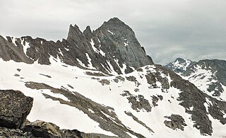
Lizard Head Peak is in the southern Wind River Range in the U.S. state of Wyoming. Situated in Shoshone National Forest, Lizard Head Peak is the northeasternmost peak in the Cirque of the Towers, a popular climbing area. Lizard Head Glacier is just WNW of the peak.

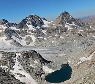
Mount Warren is located in the Wind River Range in the U.S. state of Wyoming. The peak is the third peak in the range and the fourth tallest in Wyoming. The summit is located in the Fitzpatrick Wilderness of Shoshone National Forest and rises above several glaciers, the best known being Dinwoody Glacier which is immediately north of the summit tower. The mountain abuts, but is not within, either Bridger National Forest or Sublette County, Wyoming.

Mount Helen is located in the Wind River Range in the U.S. state of Wyoming. The peak is the fourth highest peak in the range and the fifth tallest in Wyoming. The summit is located in the Bridger Wilderness of Bridger-Teton National Forest, immediately west of the Continental Divide. The eastern flanks of the mountain are covered in snowfields and glaciers, including Helen and Sacagawea Glaciers, all of which are in the Fitzpatrick Wilderness of Shoshone National Forest.
Turret Peak is the sixth-highest peak in the U.S. state of Wyoming and the fifth-highest in the Wind River Range. The Dinwoody Glacier is located on the northwest slope of the mountain, while the Helen Glacier is to the south. Turret Peak is estimated to be between 13,606 to 13,646 feet high.

Mount Sacagawea is the eighth-highest peak in the U.S. state of Wyoming and the seventh-highest in the Wind River Range. It was named after Sacagawea, the young Lemhi Shoshone woman who accompanied the Lewis and Clark Expedition as an interpreter and guide. The Upper Fremont Glacier is located southeast and the Sacagawea Glacier is northeast of the mountain. Straddling the Continental Divide, Mount Sacagawea is one mile (1.6 km) northwest of Fremont Peak.
Jackson Peak 13,523 feet (4,122 m) is the eighth-highest peak in the U.S. state of Wyoming and the seventh-highest in the Wind River Range. The Bull Lake Glacier is located immediately north and east of the mountain. Situated on the Continental Divide, Jackson Peak is .75 miles (1.21 km) southeast of Fremont Peak.

Mount Woodrow Wilson is located in the Wind River Range in the U.S. state of Wyoming. Mount Woodrow Wilson is the eighth-highest mountain in the range and the ninth-highest in Wyoming. The summit is located in the Bridger Wilderness of Bridger-Teton National Forest on the Continental Divide, 1.25 miles (2.01 km) south of Gannett Peak. The flanks of the mountain are covered in snowfields and glaciers, including Dinwoody Glacier to the northeast, Mammoth Glacier to the west and Sphinx Glacier to the south.
Bastion Peak, at 13,500 feet (4,100 m), is located in the Wind River Range in the U.S. state of Wyoming. The peak is the ninth-highest in the range and the tenth-highest in Wyoming. The summit is located on the Continental Divide and the eastern slopes of the mountain are covered by a section of Gannett Glacier, the largest glacier in the American Rocky Mountains. An arête to the northeast leads to Bastion Peak-Northeast Peak, which, at 13,476 ft (4,107 m), is also one of the highest points in Wyoming.

Klondike Peak is located in the northern Wind River Range in the U.S. state of Wyoming. Situated 4 mi (6.4 km) north of Gannett Peak, Klondike Peak is within the Bridger Wilderness of Bridger-Teton National Forest and west of the Continental Divide. The summit of Klondike Peak is partially capped by a small glacier and the northwest flank of the peak is the origination point of J Glacier, while Sourdough Glacier lies just to the northeast. Klondike Peak is the 26th tallest peak in Wyoming.
Knife Point Mountain is located in the northern Wind River Range in the U.S. state of Wyoming. Situated 2.7 mi (4.3 km) southeast of Fremont Peak, Knife Point Mountain is on the Continental Divide. North of Knife Point Mountain is the origination point of Knife Point Glacier, while Harrower Glacier lies just to the west. Knife Point Mountain is the 32nd tallest peak in Wyoming.
Mount Whitecap is located in the northern Wind River Range in the U.S. state of Wyoming. Situated 2.25 mi (3.62 km) southwest of Gannett Peak, Mount Whitecap is in the Bridger Wilderness of Bridger-Teton National Forest. Baby Glacier lies just to the east of the peak and Split Mountain is 1 mi (1.6 km) southeast. Mount Whitecap is the 30th tallest peak in Wyoming.
Bow Mountain is located in the northern Wind River Range in the U.S. state of Wyoming. Situated 1 mi (1.6 km) west of American Legion Peak, Bow Mountain is in the Bridger Wilderness of Bridger-Teton National Forest. Stroud Glacier lies just to the north of the peak. Bow Mountain is the 29th tallest peak in Wyoming.
Harrower Peak is located in the northern Wind River Range in the U.S. state of Wyoming, and it is the 28th tallest mountain in the state. Harrower Peak is in the Bridger Wilderness of Bridger-Teton National Forest and the Harrower Glacier is less than .50 mi (0.80 km) northeast of the peak.

Split Mountain is located in the Wind River Range in the U.S. state of Wyoming. Split Mountain is the 22nd highest peak in Wyoming. Split Mountain is in the Bridger Wilderness of Bridger-Teton National Forest and is about .70 mi (1.13 km) northwest of Twin Peaks and 1 mi (1.6 km) southeast of Mount Whitecap. Mammoth Glacier is on the northeast slopes of the peak while the smaller Baby Glacier flows down from a spur to the northwest.
The Sphinx is a 13,264-foot (4,043 m) mountain in the Wind River Range in the U.S. state of Wyoming. The summit is on the Continental Divide in both Shoshone and Bridger-Teton National Forests and it is .38 mi (0.61 km) east-southeast of Mount Woodrow Wilson. The Dinwoody Glacier flows from the north slopes of the peak, while Sphinx Glacier is on the southwest flank of the mountain.
Mount Lander is located in the central Wind River Range in the U.S. state of Wyoming. Mount Lander is within the Wind River Indian Reservation. The Lander Glacier consists of three distinct glaciers on the north and west slopes of Mount Lander, with the westernmost glacier being the largest. Baptiste Lake is 1 mi (1.6 km) long and is on the southeast base of Mount Lander and the famous northeast wall of Mount Hooker is another mile south of the lake.

Mount Washakie is located in the Wind River Range in the U.S. state of Wyoming. The mountain is on the Continental Divide in the Bridger Wilderness of Bridger-Teton National Forest and Popo Agie Wilderness of Shoshone National Forest. Washakie Glacier lies .50 mi (0.80 km) to the southeast of the peak.
Bair Peak is located in the Wind River Range in the U.S. state of Wyoming. The mountain is on the Continental Divide in the Bridger Wilderness of Bridger-Teton National Forest and Popo Agie Wilderness of Shoshone National Forest. Washakie Glacier lies on the north slopes of the peak.
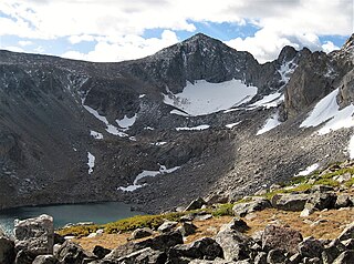
Mount Chauvenet is a mountain located in the southern Wind River Range in the U.S. state of Wyoming. Mount Chauvenet is 1.5 mi (2.4 km) northeast of Cathedral Peak in the Popo Agie Wilderness of Shoshone National Forest. Mount Chauvenet was one of the earliest peaks climbed by white explorers to the Wind River Range.
