Foggydog Glacier is a glacier between the Blank Peaks and Mount Rich in the Brown Hills of Antarctica. It was mapped by the Victoria University of Wellington Antarctic Expedition (1962–63) and so named because in plan the glacier is shaped like the head and neck of a dog, with a moraine suggesting a collar and a glacial lake in the position of the ears. Fog accumulates regularly over the glacier.

Schoolroom Glacier is a small glacier in Grand Teton National Park in the U.S. state of Wyoming. This Teton Range glacier lies adjacent to the south Cascade Canyon trail at an altitude of 10,400 ft (3,200 m), approximately 12 mi (19 km) from the trailhead at Jenny Lake. The glacier has many of the classic textbook details of a glacier, namely, well defined terminal and lateral moraines, crevasses, a proglacial lake and related features which led to the naming schoolroom.

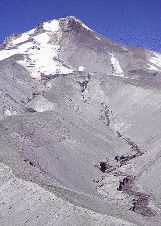
Upper Fremont Glacier is in the Fitzpatrick Wilderness of Shoshone National Forest in the U.S. state of Wyoming. This Wind River Range alpine glacier is associated with the largest grouping of glaciers in the U.S. Rocky Mountains and lies on the north slope of Fremont Peak, the third tallest mountain in Wyoming. Upper Fremont Glacier is at an average altitude of 13,450 ft (4,100 m) and is one of the highest altitude glaciers in the American Rockies.

Signal Mountain is an isolated summit standing 7,720 feet (2,350 m) above sea level. The mountain is located in Grand Teton National Park in the U.S. state of Wyoming. The next closest higher summit is more than 10 miles (16 km) distant, and this isolation provides sweeping views of the Teton Range, much of the northern Jackson Hole area as well as the Snake River. Though located adjacent to the Tetons, Signal Mountain was not formed in the same manner or period. The mountain originally was formed by volcanic ashfall from one of the eruptions of the Yellowstone hotspot. The peak is also partially a glacial moraine formed by a receding glacier that came south out of the Yellowstone icecap. This same glacier also created neighboring Jackson Lake.

Carbon Glacier is located on the north slope of Mount Rainier in the U.S. state of Washington and is the source of the Carbon River. The snout at the glacier terminal moraine is at about 3,500 feet (1,100 m) above sea level, making it the lowest-elevation glacier in the contiguous United States. The glacier also has the greatest length, thickness and volume of any U.S. glacier outside of Alaska.

Mount Sacagawea is the eighth-highest peak in the U.S. state of Wyoming and the seventh-highest in the Wind River Range. It was named after Sacagawea, the young Lemhi Shoshone woman who accompanied the Lewis and Clark Expedition as an interpreter and guide. The Upper Fremont Glacier is located southeast and the Sacagawea Glacier is northeast of the mountain. Straddling the Continental Divide, Mount Sacagawea is one mile (1.6 km) northwest of Fremont Peak.

Jackson Peak 13,523 feet (4,122 m) is the eighth-highest peak in the U.S. state of Wyoming and the seventh-highest in the Wind River Range. The Bull Lake Glacier is located immediately north and east of the mountain. Situated on the Continental Divide, Jackson Peak is .75 miles (1.21 km) southeast of Fremont Peak.
Heap Steep Glacier is located east of the Continental Divide in the northern Wind River Range in the US state of Wyoming. The glacier is situated in the Fitzpatrick Wilderness of Shoshone National Forest, and is among the largest grouping of glaciers in the American Rocky Mountains. Heap Steep Glacier is in a north facing cirque, below the summit of Sunbeam Peak. A large terminal moraine and small proglacial lake are located below the glacier.

Helen Glacier is located east of the Continental Divide in the northern Wind River Range in the US state of Wyoming. The glacier is located in the Fitzpatrick Wilderness of Shoshone National Forest, and is among the largest grouping of glaciers in the American Rocky Mountains. Helen Glacier flows to the east from a cirque to the northeast of Mount Helen.
Sacagawea Glacier is east of the Continental Divide in the northern Wind River Range in the U.S. state of Wyoming. The glacier is located in the Fitzpatrick Wilderness of Shoshone National Forest, and is among the largest grouping of glaciers in the American Rocky Mountains. Sacagawea Glacier flows to the east, from a northeast facing cirque, starting near the summit of Mount Sacagawea. A large moraine and small proglacial lake are situated beyond the terminal east end of the glacier.
Bull Lake Glacier is located immediately east of the Continental Divide in the northern Wind River Range in the U.S. state of Wyoming. The glacier is in the Fitzpatrick Wilderness of Shoshone National Forest, and is among the largest grouping of glaciers in the American Rocky Mountains. Bull Lake Glacier flows to the east and starts below the summit of Jackson Peak. It is adjacent to Lower Fremont Glacier though the two are separated by a moraine.
Knife Point Glacier is on the east side Continental Divide in the northern Wind River Range in the U.S. state of Wyoming. The glacier is in the Fitzpatrick Wilderness of Shoshone National Forest, and is among the largest grouping of glaciers in the American Rocky Mountains. Knife Point Glacier flows to the north and starts below the summit of Knife Point Mountain.
Harrower Glacier is located on the west side of the Continental Divide in the northern Wind River Range in the US state of Wyoming. The glacier is in the Bridger Wilderness of Bridger-Teton National Forest, and is among the largest grouping of glaciers in the American Rocky Mountains. Harrower Glacier flows to the north and is situated in a cirque, below the summit of Knife Point Mountain.
White River Glacier is an alpine glacier located on the south slopes of Mount Hood in the U.S. state of Oregon. It ranges in elevation from about 10,000 to 6,200 feet. It is among the best known of the twelve glaciers on the mountain, and the lower reaches are a popular destination for Nordic skiing enthusiasts. The glacier is the source of the White River, a tributary of the Deschutes River, and has a long history of washing out the bridge where Oregon Route 35 crosses at 45.30307°N 121.67208°W.
Prouty Glacier is located in the U.S. state of Oregon. The glacier is situated in the Cascade Range at an elevation generally between 9,500 and 8,500 feet. Prouty Glacier is on the northeast slopes of South Sister, a dormant stratovolcano. Beyond the current range of the glacier, glacially formed Carver Lake lies to the immediate northeast of Prouty Glacier and is impounded by the old terminal moraine of the glacier.
Benson Glacier is in the U.S. state of Oregon. The glacier is situated in the Wallowa Mountains at an elevation generally above 8,500 feet (2,600 m) on the eastern slopes Glacier Peak, a subpeak of Eagle Cap. The glacier was named in honor of Frank W. Benson, former Governor of Oregon during an expedition in 1914. Benson Glacier is estimated to be 560 ft (170 m) long. Due to its small size, researchers have frequently questioned whether it was a glacier or a perennial snowfield. Areal photography taken in 2007 showed crevasses on the surface, confirming that it does flow and is a true glacier. It is not expected to remain a true glacier much longer, however, due to climate change.
Moomaw Glacier is an alpine glacier in Rocky Mountain National Park in the U.S. state of Colorado. Moomaw Glacier is almost 1 mi (1.6 km) northeast of Isolation Peak and the old terminal moraine of the glacier impounds Frigid Lake.
Tiny Glacier is in the Wind River Range, Bridger-Teton National Forest, in the U.S. state of Wyoming. The glacier is situated in a north-facing cirque immediately west of the Continental Divide.
Gotchen Glacier is located on the south slopes of Mount Adams, a stratovolcano in the Gifford Pinchot National Forest in the U.S. state of Washington. The glacier descends from approximately 8,200 ft (2,500 m) to a terminus near 7,400 ft (2,300 m) below, where an old terminal moraine and proglacial lake exist. Gotchen Glacier has been in a general state of retreat for over 100 years and lost 78 percent of its surface area between 1904 and 2006.
